Saundersfoot & Tenby
Pembrokeshire Coast Walk
Nat Park - Pembrokeshire Coast
County/Area - Pembrokeshire
Author - Lou Johnson
Length - 4.5 miles / 7.3 km Ascent - 825 feet / 250 metres
Time - 3 hours 10 minutes Grade - easy/mod
Maps 

| Ordnance Survey Explorer OL36 | Sheet Map | 1:25k | BUY |
| Anquet OS Explorer OL36 | Digital Map | 1:25k | BUY |
| Ordnance Survey Landranger 158 | Sheet Map | 1:50k | BUY |
| Anquet OS Landranger 158 | Digital Map | 1:50k | BUY |
Walk Route Description
Click image to visit gallery of 6 images.
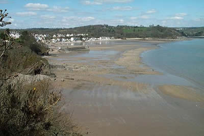
Coastal walking is always full of surprises and is often tougher than you originally think. This linear route includes a pleasant section of the Pembrokeshire Coast Path together with an interesting seaside town. The start is the main carpark just behind the harbour at Saundersfoot (grid ref. SN136046). This small resort has a good beach and the usual facilities you would expect.
There are two possible starts for this walk depending on the tide. At high water you need to leave the harbour on the B4316 towards Tenby. The road takes a sharp left followed by a sharp right as it climbs away from the harbour. Shortly afterwards a left turn down a minor road will bring you to the coastal path. Tides permitting the more attractive route is along the south side of the harbour from where you can cross the sands and rocks to reach the same point as above (grid ref. SN138043).
From this point detailed instructions are not really necessary as all you need to do is follow the well trodden and well-signed coastal path south. At Monkstone Point it is worth following one of the minor paths onto the headland as there are good views from here.
Many people are surprised by the amount of descent and ascent on coastal routes and this walk is no exception. Twisting and turning there are plenty of ups and downs to contend with on this path. Reaching the deep valley of Waterwynch the path drops almost to sea level before climbing out of the valley on a paved path that runs a little inland. This soon joins a minor road which is followed into Tenby.
Reaching the access to North Beach continue across the sands to the small harbour (tides permitting!). The area around the harbour is full of interest with some fine buildings and the usual bustle associated with maritime activity. If time permits a stroll around Castle Hill is worthwhile as is more detailed investigation of the town of Tenby.
There are two options for the return to Saundersfoot The most obvious is to retrace the outward route or possible make a few minor alterations using different footpaths on the first section north from Tenby. The second choice is to use the regular bus service which leaves at frequent intervals from Tenby town centre. Tenby Tourist information Office (located near North Beach) has details of where the bus starts and the timetable. The journey time is about twenty minutes with buses terminating by the harbour in Saundersfoot.
Other walks nearby
| Walk 3475 | Caldey Island Circular | easy | 3.0 miles |
| Walk 3363 | Swanlake Bay from Manorbier | easy/mod | 4.8 miles |
| Walk 3369 | Pendine to Amroth Coast Path | moderate | 5.7 miles |
| Walk 3364 | The Stackpole Estate from Stackpole Quay | easy | 5.0 miles |
| Walk 3366 | Bosherston Lily Ponds | easy | 3.4 miles |
| Walk 3365 | Bosherston Lily Ponds, Broad Haven & St. Govan's Chapel | easy/mod | 5.0 miles |
| Walk 3495 | St. Govan's Chapel, Bosherston & Elegug Stacks | moderate | 9.6 miles |
| Walk 1880 | Ferryside & Llansaint | easy/mod | 5.0 miles |
| Walk 3498 | Freshwater West & Angle | moderate | 8.7 miles |
| Walk 3469 | Foel Cwmcerwyn from Rosebush, Preseli Hills | moderate | 5.0 miles |
Recommended Books & eBooks
The Wales Coast Path
 A single guidebook to walking the whole Wales Coast Path - 1400km (870 miles) the length of Wales from Chester to Chepstow, including Anglesey, described in 57 stages. The route passes through the Snowdonia and Pembrokeshire National Parks and many AONBs and can be linked with the Offa's Dyke Path for a complete circuit of Wales.
More information
Messaging & Social Media
Message Walking Britain and follow the latest news.

Mountain Weather
Stay safe on the mountains with detailed weather forecasts - for iOS devices or for Android devices.