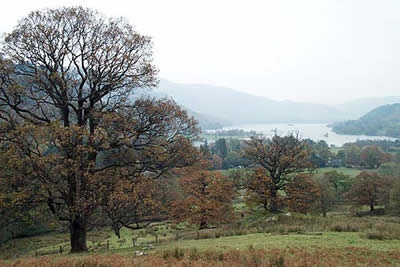
Birks & Arnison Crag from Patterdale
Lake District Walk
Nat Park - Lake District - Lake District Eastern Fells
Wainwrights - Arnison Crag, Birks
County/Area - Cumbria
Author - Lou Johnson
Length - 5.5 miles / 8.9 km Ascent - 1775 feet / 538 metres
Time - 4 hours 30 minutes Grade - moderate
Maps 

| Ordnance Survey Explorer OL5 | Sheet Map | 1:25k | BUY |
| Anquet OS Explorer OL5 | Digital Map | 1:25k | BUY |
| Ordnance Survey Landranger 90 | Sheet Map | 1:50k | BUY |
| Anquet OS Landranger 90 | Digital Map | 1:50k | BUY |
Walk Route Description
Click image to visit gallery of 4 images.
Despite its relatively short length, this Lake District circular walk has plenty to offer including a steep ascent from Grisedale onto the flanks of St. Sunday Crag. The route was researched during murky conditions so the images do not do justice to the superb views that can be enjoyed.
The start is the small car park in Patterdale (grid ref. NY395159) where a charge is made for parking. Leave the car park and walk south along the main road to reach the shop on your left. Just after turn right and follow the track that goes to the right of the toilets. Stay on this to pass a building on your right before taking a signed path left. Continue on this path as it goes through Glenamara Park keeping the wall on your right.
The path meanders pleasantly with a steep fellside on your left. Reaching a sheep pen (grid ref. 382155) go through the wall and follow the path down to the road/track that runs on the southern side of Grisedale. Turn left along this to walk southwest. Ahead are good views of Dollywaggon Pike and Nethermost Pike and you can also see Striding Edge high above the valley floor. The walking is easy and you make rapid progress soon reaching Elmhow Plantation. At the western end of the trees turn left and follow a steep path that heads up the fellside. Reaching the top of the plantation, cross the stream and locate the rising grassy path that leads upwards into Blind Cove.
The ascent is steep and you have some 700 feet to climb before the going gets easier! The path is cleverly constructed making fairly rapid upward progress in a series of zigzags. Provided you have the OS 1:25000 map then you will find the path marked and it is important that you do not go astray when you reach Blind Cove, which is a wide depression in the fellside. One path heads southwest to the foot of St. Sunday Crag and this is not the path to take. Instead pick up the path heading almost due east that follows a small stream as it climbs. Quite quickly you reach the main path used for ascents and descents of St. Sunday Crag and here you should turn right to head southwest towards the latter fell's summit.
The main path is followed for a short way until you cross a stream. Here turn sharp left and make for the summit of Birks. There are now good views ahead to Place Fell and the Far Eastern Fells and the summit is an ideal spot to stop for a rest. Leaving the summit continue on the path that aims for Place Fell until you reach a large cairn, which looks as though it has been recently rebuilt. Turn right here and descend to locate a wall end (grid ref. 384145). Keeping the wall on your left descend steeply on a feint path. Reaching some low crags the wall turns left and from here you should make a beeline for the col of Trough Head where a couple of murky pools add interest to an otherwise bleak fellside.
Turning northeast from the col a choice of paths leads you along a pleasant ridge to the pleasant rocky summit of Arnison Crag. Like many of the lower 'Wainwrights' the view is superb and you can spend quite some time absorbing the detail of the scenery. All good things must end and descending north from the summit follow the path beside the wall down into Patterdale. At the bottom you join the outward route and all that remains is a pleasant stroll back to your transport.
Other walks nearby
| Walk 1156 | Helvellyn via Striding Edge | hard | 9.5 miles |
| Walk 1235 | Red Tarn & Grisedale | moderate | 7.0 miles |
| Walk 1710 | Glenridding, St. Sunday Crag & Helvellyn | hard | 11.5 miles |
| Walk 3232 | Glenridding Dodd & Sheffield Pike | easy/mod | 4.5 miles |
| Walk 2327 | Red Tarn & Birkhouse Moor from Glenridding | moderate | 6.0 miles |
| Walk 3668 | Catstye Cam from Glenridding | mod/hard | 7.0 miles |
| Walk 1110 | Angletarn Pikes | moderate | 7.0 miles |
| Walk 2060 | The Angletarn Pikes and Brock Crags from Hartsop | moderate | 8.0 miles |
| Walk 3388 | Hayeswater and Angle Tarn from Hartsop | mod/hard | 11.5 miles |
| Walk 2386 | Red Screes via Dove Crag | mod/hard | 8.6 miles |
Recommended Books & eBooks
The Cumbria Way
 A guidebook to the 73 mile Cumbria Way, an easy long-distance walk though the heart of the Lake District National Park, from Ulverston in the south to Carlisle in the north, with good transport links to either end. The route is largely low-level but this guide offers alternative mountain days to climb some of the famous fells en route.
More information
Walking the Lake District Fells - Keswick
 Part of the Walking the Lake District Fells series, this guidebook covers a wide range of routes to 30 Lakeland summits that can be climbed from Keswick, Whinlatter, Bassenthwaite, Caldbeck, Mungrisdale and Threlkeld, with highlights including Skiddaw and Blencathra. Includes suggestions for longer ridge routes.
More information
Messaging & Social Media
Message Walking Britain and follow the latest news.

Mountain Weather
Stay safe on the mountains with detailed weather forecasts - for iOS devices or for Android devices.