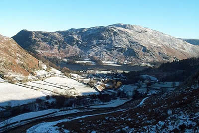
Red Tarn & Grisedale from Glenridding
Lake District Walk
Nat Park - Lake District - Lake District Eastern Fells
County/Area - Cumbria
Author - Lou Johnson
Length - 7.0 miles / 11.4 km Ascent - 2320 feet / 703 metres
Time - 5 hours 50 minutes Grade - moderate
Maps 

| Ordnance Survey Explorer OL5 | Sheet Map | 1:25k | BUY |
| Anquet OS Explorer OL5 | Digital Map | 1:25k | BUY |
| Ordnance Survey Landranger 90 | Sheet Map | 1:50k | BUY |
| Anquet OS Landranger 90 | Digital Map | 1:50k | BUY |
Walk Route Description
Click image to visit gallery of 8 images.
This Lake District walk takes you into the heart of the Helvellyn range and includes an optional ascent of Catstye Cam, which is sadly very rarely the main objective of a walk. The walk uses well maintained paths throughout and although no summits are included you get that feeling of being right there in the middle of the 'action'.
Park in the main car park at Glenridding located adjacent to the Visitor Centre. Retrace you steps to the main road and turn right over Glenridding Beck and right again to follow the lane westwards. This leads into a footpath that takes you to Rattlebeck Bridge. Turn left onto the farm track and climb the signed footpath to reach a stile. Rather than take the main footpath into Little Cove, turn right and follow the path that contours across the fellside with the intake wall on your right. This leads very pleasantly into the hills to reach Glenridding Beck (grid ref NY363173). Do not cross but turn left and follow the broad path with the Beck on your right.
Ahead lies the eastern flank of Catstye Cam with the path climbing steadily to reach Red Tarn. You cross a footbridge and begin climbing until you get your first view of Helvellyn with Striding Edge to its left. The rate of ascent eases and Red Tarn comes into view with a wonderful surround of crags and the perfect place to have a break.
If you are feeling energetic then an optional ascent of Catstye Cam can be completed quite quickly. Take the clear path on the north side of the Tarn leading to Swirral Edge. Once you are on the edge turn right and within a few minutes you will reached the summit of this distinctive mountain. The view is excellent especially in the immediate vicinity. After enjoying the view retrace your steps to Red Tarn.
From Red Tarn cross Red Tarn Beck and take the clear path heading eastwards to the "Hole in the Wall". Cross the stile and head down the path descending into Grisedale. You have superb views of St Sunday Crag and can also appreciate the steep southern flank of Striding Edge as it plunges into the valley. Almost reaching the valley floor (grid ref 381159) continue ahead and follow the clear path/track that climbs and turns north to pass Lanty's Tarn on your right. The direct path into Glenridding has been diverted so you are forced to take a wide zigzag that brings you down to Westside. Continue on the track to reach the centre of Glenridding.
Other walks nearby
| Walk 1230 | Birks & Arnison Crag | moderate | 5.5 miles |
| Walk 1520 | Helvellyn & Fairfield Horseshoe from Patterdale | very hard | 13.0 miles |
| Walk 2047 | Place Fell | moderate | 7.5 miles |
| Walk 2425 | Boredale Circular from Patterdale | mod/hard | 11.5 miles |
| Walk 3670 | Angle Tarn and Hayeswater | moderate | 8.3 miles |
| Walk 1110 | Angletarn Pikes | moderate | 7.0 miles |
| Walk 2060 | The Angletarn Pikes and Brock Crags from Hartsop | moderate | 8.0 miles |
| Walk 3388 | Hayeswater and Angle Tarn from Hartsop | mod/hard | 11.5 miles |
| Walk 2386 | Red Screes via Dove Crag | mod/hard | 8.6 miles |
| Walk 2039 | Gowbarrow Fell circular | moderate | 3.5 miles |
Recommended Books & eBooks
Walking the Lake District Fells - Mardale and the Far East
 Part of the Walking the Lake District Fells series, this guidebook covers a wide range of routes to 36 Lakeland summits that can be climbed from the Ullswater, Haweswater, Troutbeck, Kentmere and Longsleddale valleys, with highlights including High Street, Place Fell and the Kentmere fells. Suggestions for longer ridge routes are also included.
More information
Outdoor Adventures with Children - Lake District
 Guidebook to 40 outdoor adventures in the Lake District with children under 12, including walking, cycling, orienteering, paddling, boating, hostelling and more. Graded activities for varying age ranges or for families with children of different ages.
More information
Messaging & Social Media
Message Walking Britain and follow the latest news.

Mountain Weather
Stay safe on the mountains with detailed weather forecasts - for iOS devices or for Android devices.