Loch Avon Circular via Cairn Gorm Mountain
Cairngorms Walk
Nat Park - Cairngorms - Cairngorm North
County/Area - Highland
Author - Andy Smith & Sarah Amer
Length - 9.0 miles / 14.6 km Ascent - 3600 feet / 1091 metres
Time - 8 hours 10 minutes Grade - hard
Maps 

| Ordnance Survey Explorer OL57 | Sheet Map | 1:25k | BUY |
| Anquet OS Explorer OL57 | Digital Map | 1:25k | BUY |
| Ordnance Survey Landranger 36 | Sheet Map | 1:50k | BUY |
| Anquet OS Landranger 36 | Digital Map | 1:50k | BUY |
Walk Route Description
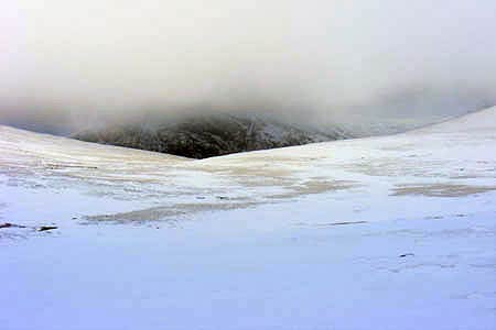
Click image to visit gallery of 9 images.
This tough route takes in a remote Loch high on the Cairngorm Plateau, which is best enjoyed in winter conditions. The exit takes you up the east face of Cairn Gorm summit making it a worthy day out. The walk is possible as a day option during winter months, but an early start is required. Conditions down to Loch Avon (pronounced "ainne" in English) are challenging and will require winter skills using ice axe and crampons. You should also be fully aware how to use these as there is one awkward section on this descent. In summer the conditions are easier but this remains a tough excursion into the Cairngorm Mountains and you may encounter some harsh weather at all times of the year. Whatever the season make sure you are well equipped and know how to use it.
Start by parking the car in the Coire na Ciste Ski Centre (grid ref. NH990060) located 11 miles east of Aviemore. Leave the car park to the southeast following the vehicle access road to Shieling Station. Continue along for 300 metres and locate a path with steps to your right (grid ref. NH995050), which can be tricky to find in heavy snow. After 45 minutes the track meets a ski tow fence, this is a good place to gear up for the icy walk up the ridge of Fiacaill a' Choire Chais.
Leave the fence and follow up the obvious ridge keeping the rocks to your right. Stay close as the drop to your left increases and is often corniced near the summit. The summit of the ridge is marked by a huge cairn which can provide some welcome shelter. Remember the wind speed often varies between 50 and 80mph even on a normal winter's day.
Leave the cairn to the southeast. In clear conditions you will see a faint track following the Allt Coire Raiberirt River to the left as you slowly descend towards Loch Avon. The first sighting of Loch Avon is quite dramatic appearing far below and making a dramatic photo. Within 20 minutes the track starts to descend steeply with increasing exposure to your right. Around half way down there is a tricky section made worse by exposure to your right. This involves a large rock facing downhill towards the drop and is quite often iced over. Passing over this with good condition crampons is possible. However I chose to take a lower line with the drop behind me making a good hold with the axe in the snow and soil behind the rock. Remember to take great care on this section. After another 10 minutes or so another tricky section is reached. Not as bad as the first, the best option here is to simply stay on the path maintaining your centre of gravity close to the rock then stepping down backwards. After these two sections are cleared you can relax knowing the worst is now over as you stride down towards the loch.
Once the loch is reached locate the well defined path and turn right. You are now on the Loch Avon circular. The path stays close to the waters edge in general but does rise to cross some snow slopes in places, keeping the crampons on does help as you make your way to the intake where a small footbridge is found. Cross the bridge and continue round under the awesome slopes of Stacan Dubha until a ford is reached; cross here and continue along for about an hour until the eastern outlet is reached. Crossing here is helped in winter as there is less water but still take care crossing. After warm periods melting snow can cause increased river flows so if in doubt ask at the ranger station by the ski centre for advice before attempting this route.
The river successfully crossed, locate the path opposite and turn left. Within minutes the path rises steeply as you stride towards The Saddle (grid ref. NJ019034). Continue straight ahead following the water (or ice) picking up a path leading up the east face of Cairn Gorm. As the summit nears the path quite often disappears under solid ice but the going ahead is quite clear with the summit in sight. After a gruelling hour the summit is finally reached; if you are slightly off target then the worst situation you will find yourself in is a trail of clearly laid out cairns leading up to the summit. Once reached you can take in fine views all around, looking south you take in the scale of the Cairngorms, to the southwest Loch Morlich almost looks like a puddle with Aviemore just about visible beyond.
Leave the summit following the cairns and make your way back down to Ptarmigan Station. From here leave the station crossing the first ski tow and turn left keeping the tow to your right. Follow down for about half an hour and the path turns left again, well marked with cairns. Follow sharply downhill back to the ski centre and a phone box. Turn right back into the car park where you can either leave or enjoy a well earned drink in the walkers bar.
Other walks nearby
| Walk 2421 | Braeriach via the Chalamain Gap | hard | 15.0 miles |
| Walk 1605 | Loch an Eilein & Rothiemurchus Forest from Loch Morlich | easy/mod | 10.0 miles |
| Walk 2607 | Lairig Ghru & Chalamain Gap from Glenmore | mod/hard | 11.0 miles |
| Walk 3579 | Meall a'Bhuachaille & Ryvoan Bothy from Glenmore | moderate | 5.5 miles |
| Walk 3218 | Eag a' Chait gap Via Rothiemurchus Lodge from Glenmore | moderate | 8.2 miles |
| Walk 1020 | Glenmore to Linn of Dee via Lairig Ghru & Corrour | hard | 21.0 miles |
| Walk 2412 | Craiggowrie & Creagan Gorm from Loch Morlich | mod/hard | 7.3 miles |
| Walk 1904 | Loch Morlich circular (near Aviemore) | easy | 4.0 miles |
| Walk 1721 | Braeriach via Lairig Ghru | hard | 18.2 miles |
| Walk 3299 | Loch an Eilein from Coylumbridge | easy/mod | 7.0 miles |
Recommended Books & eBooks
Great Mountain Days in Scotland
 Inspirational guidebook to 50 challenging routes for mountaineers, scramblers, hillwalkers and fell runners, many long enough to backpack over 2 days, especially in winter (12 to 25 miles). A mix of classic routes and unsung gems across Scotland from Galloway to the Outer Hebrides in widely differing wild landscapes. With customised OS mapping.
More information
Walking in Torridon
 This guidebook contains 52 day walks in Torridon, a remote and much-loved area of the Scottish Highlands. Based around Shieldaig and Slioch, the routes are split into 3 sections: easy walks, long and high level walks and mountain ascents over 2000ft including 9 Munros, and 5 outline suggestions for major ridge walks.
More information
Messaging & Social Media
Message Walking Britain and follow the latest news.

Mountain Weather
Stay safe on the mountains with detailed weather forecasts - for iOS devices or for Android devices.