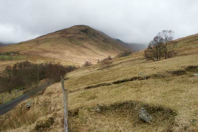
Beinn Eich & Doune Hill from Glenmollochan Farm
Loch Lomond and Trossachs Walk
Nat Park - Loch Lomond and Trossachs
County/Area - Argyll and Bute
Author - Lou Johnson
Length - 8.0 miles / 13 km Ascent - 3030 feet / 918 metres
Time - 7 hours 0 minutes Grade - mod/hard
Maps 

| Ordnance Survey Explorer OL39 | Sheet Map | 1:25k | BUY |
| Anquet OS Explorer OL39 | Digital Map | 1:25k | BUY |
| Ordnance Survey Landranger 56 | Sheet Map | 1:50k | BUY |
| Anquet OS Landranger 56 | Digital Map | 1:50k | BUY |
Walk Route Description
Click image to visit gallery of 3 images.
The Luss Hills lie to the west of Loch Lomond. They are steep-sided and grassy, which despite their relatively low height provide a basis for some excellent walking. Parking is very limited in Glen Luss but as an alternative you can use the car parks beside Loch Lomond in the village although this adds some extra distance to the route.
There is a small area where a few cars can be parked near the drive to Glenmollochan Farm (Grid ref. NS330942). From here continue up the lane to Edentaggart crossing the stream flowing down Glen Mollochan. On your right is a signed footpath to Beinn Eich, which is followed uphill to a stile in a wall. Cross the stile and continue the uphill work to reach the summit of Beinn Eich. The views are good and the effort of gaining the summit well rewarded.
To continue descend northwest along the ridge losing about 500 feet to reach a col. Ignore the path descending right into the glen and continue along the main ridge climbing steadily onto Beinn Lochain. A further descent, with the path turning northeast, leads you to the summit of Doune Hill with its trig point. From here the view down Glen Mollochan is particularly noteworthy as are the views in other directions.
An ill-defined path leads east off the summit of Doune Hill dropping some 450 feet over hummocky ground with a few crags that need avoiding to reach a lochan. Turn southeast and follow the developing stream which is shadowed by a line of derelict fenceposts into Glen Mollochan. There are traces of a path for most of the descent but it is probably easier to stay on the north side of the stream to reach the valley floor.
A clearer path develops near grid ref. NS 304960 near a large rock and this should be followed on the north side of the glen to meet a landrover track (Grid ref. NS 318947), which is followed back to the lane. Turn left along the lane and the parking area is a short walk downhill.
Other walks nearby
| Walk 3009 | Ben Lomond | mod/hard | 7.5 miles |
| Walk 1493 | WHW - Day 3 - Rowardennan to Inverarnan | moderate | 14.0 miles |
| Walk 2659 | Conic Hill | easy/mod | 4.0 miles |
| Walk 1298 | The Cobbler | mod/hard | 7.5 miles |
| Walk 1459 | Ben Arthur ("The Cobbler") | mod/hard | 7.5 miles |
| Walk 2347 | Duncryne from Gartocharn | easy | 2.0 miles |
| Walk 1492 | WHW - Day 2 - Dryden to Rowardennan | moderate | 15.0 miles |
| Walk 2317 | Ben Vorlich from Ardlui | mod/hard | 6.8 miles |
| Walk 2413 | Ben Venue from Loch Achray | moderate | 8.2 miles |
| Walk 2309 | Ben A'an from Loch Achray | easy/mod | 2.5 miles |
Recommended Books & eBooks
Walking Loch Lomond and the Trossachs
 A guide to walking and scrambling routes in the beautiful Loch Lomond and the Trossachs National Park. Over 70 graded low-level, mid-level and mountain walks taking in hills, glens and picturesque woodland, as well as all of the region's Munro summits. Highlights include Ben Lui, Ben Lomond, the Cobbler and the Arrochar Alps.
More information
Messaging & Social Media
Message Walking Britain and follow the latest news.

Mountain Weather
Stay safe on the mountains with detailed weather forecasts - for iOS devices or for Android devices.