Chancery Lane to Trafalgar Square
London Walk
County/Area - London
Author - Lou Johnson
Length - 4.0 miles / 6.5 km Ascent - 130 feet / 39 metres
Time - 2 hours 10 minutes Grade - easy
Maps 

| Ordnance Survey Explorer 173 | Sheet Map | 1:25k | BUY |
| Anquet OS Explorer 173 | Digital Map | 1:25k | BUY |
| Ordnance Survey Landranger 176 | Sheet Map | 1:50k | BUY |
| Anquet OS Landranger 176 | Digital Map | 1:50k | BUY |
Walk Route Description
Click image to visit gallery of 6 images.
London is one of the most interesting and historic cities in Europe. Most visitors enjoy the sights using public transport within the city. However, especially at weekends, the City of London (rather than the City of Westminster) is relatively quiet. Walking enables you to enjoy the many fine buildings and the sights at your leisure being able to stop as and when you wish. This route starts at Chancery Lane tube station (Central Line) and ends at Trafalgar Square. This description does not aim to describe all the points of interest en-route but instead provides a route that links many of the key sights. It should take about 2 to 3 hours to complete although you should allow more time if you visit any of the sights.
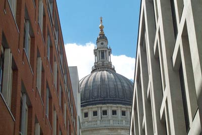
Exit Chancery Lane station (grid ref TQ311816) and walk east along Holborn continuing across Holborn Viaduct, which gives you some impression of how the city is built on low hills to the north of the River Thames. After crossing Holborn Viaduct turn left into Old Bailey passing the famous Central Criminal Court on your left. Reaching Ludgate Hill turn left and continue to St Paul's Cathedral. Just past the west front of the cathedral turn right down Godliman Street. Reaching the bottom of this street there is a sign directing you across the Millennium Bridge across the Thames.
Cross this bridge taking time to look back as the City of London skyline is impressive when viewed from here. The views downstream to Tower Bridge and upstream are also worthy of note. Reaching the south bank of the Thames you have the reconstructed Shakespearian Globe Theatre to your left and Tate Modern directly ahead.
Turn right upstream following the Thames Path under Blackfriars Bridge past the Royal National Theatre to reach Waterloo Bridge. Continuing on the riverside path you pass the Royal Festival Hall and the London Eye to reach Westminster Bridge. Go under the subway here to get the classic view of the Houses of Parliament before retracing your steps a short way to climb the stairs onto the north side of Westminster Bridge.
Cross Westminster Bridge with the Houses of Parliament and Big Ben to your left. Turn right into Whitehall with its many government buildings, Downing Street, the Cenotaph, New Scotland Yard and many other sights to reach Trafalgar Square. Dominated by Nelson's Column, this square is the end of this walk.
Other walks nearby
| Walk 1442 | St Paul's Cathedral to Green Park | easy | 5.6 miles |
| Walk 3013 | Trafalgar Square circular | easy | 3.0 miles |
| Walk 3379 | Euston to the Monument via St. Paul's | easy | 4.0 miles |
| Walk 1412 | The Monument to Trafalgar Square via Southwark | easy | 4.0 miles |
| Walk 1570 | Westminster to Green Park via St. Paul's | easy/mod | 5.5 miles |
| Walk 2651 | The City of London from Hays Galleria | easy | 3.5 miles |
| Walk 1322 | Green Park to Trafalgar Square | easy | 2.5 miles |
| Walk 2360 | Green Park to Westminster via Sloane Square | easy/mod | 5.5 miles |
| Walk 3012 | Green Park to Trafalgar Square via Lambeth Bridge | easy | 4.5 miles |
| Walk 3698 | Central London from Green Park | easy | 5.2 miles |
Recommended Books & eBooks
Walking in London
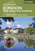 A guidebook to 25 walks in London's green spaces and nature reserves, covering both the city centre and Greater London area. Taking in woods and forests, parks and heaths, canals and rivers, the guide includes a wealth of information about some of the species you might encounter as well as the history and conservation of these areas.
More information
The Thames Path Map Booklet
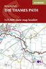 Map of the 180 mile (288km) Thames Path National Trail, from London's Thames Barrier to the river's source near Cirencester in Gloucestershire. This booklet is included with the Cicerone guidebook to the trail, and shows the full route on OS 1:25,000 maps. The easy riverside route takes around two weeks to walk.
More information
Messaging & Social Media
Message Walking Britain and follow the latest news.

Mountain Weather
Stay safe on the mountains with detailed weather forecasts - for iOS devices or for Android devices.