The Elephant Walk from Tregaron
Cambrian Mountains Walk
Region - Cambrian Mountains
County/Area - Ceredigion
Author - Dafydd Wyn Morgan
Length - 5.5 miles / 8.9 km Ascent - 500 feet / 152 metres
Time - 3 hours 20 minutes Grade - easy/mod
Maps 

| Ordnance Survey Explorer 187 | Sheet Map | 1:25k | BUY |
| Anquet OS Explorer 187 | Digital Map | 1:25k | BUY |
| Ordnance Survey Explorer 199 | Sheet Map | 1:25k | BUY |
| Anquet OS Explorer 199 | Digital Map | 1:25k | BUY |
| Ordnance Survey Landranger 146 | Sheet Map | 1:50k | BUY |
| Anquet OS Landranger 146 | Digital Map | 1:50k | BUY |
Walk Route Description
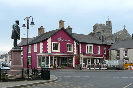
Click image to see photo description.
This linear walk starts at Bronmwyn (Gris ref. SN715645) and returns to the centre of Tregaron. The walk uses mostly defined tracks with some rough undefined sections. It can be very boggy in places. There is a long road walk at the end. The start point offers limited parking so best to leave cars in Tregaron and use taxis or buses to reach the start. Public transport is available Weekdays and Saturdays on the Tregaron to Aberystwyth route.
1 - Turn right off the B4343 onto the tiny lane leading to Bronmwyn (roughly 6.5km north of Tregaron on the B4343) and through the farmyard bearing left at the stables, then right to ford a stream. Continue through two gateways as the track winds gently uphill.
2 - Where the track bends left on a slight summit, leave it and follow a dry stone wall heading to the right, over reedy grass towards a large lone tree. From the tree, head beside the dry stone wall on the left to gain a rough path running roughly alongside a stream on the right. The path crosses the stream twice early on (poles advisable). Continue on a decreasingly distinct path near a wire fence, and ford a tributary stream coming in from the left.
3 - Roughly follow the course of the stream on an increasingly obscure path towards a farmhouse. As a (usually) dry valley joins the stream, bear right, now heading significantly to the right of the farmhouse (Cwm Gorffen) to gain a vehicle track heading up a small ridge. Follow this up past a new plantation, and through one gate, then two more to the ruined buildings of Blaengorffen.
4 - Continue following the track as it veers right of a small stream, towards the ridge of Y Bryn ahead. When the track bends left and up towards a small quarry, continue straight ahead over a small metal gate (tied up) following the line of an old dry stone wall, over somewhat boggy sheep pasture. Exit the field through another metal gate, beari8ng very slightly right to run just right of another dry stone wall on a faint grassy vehicle track. (This gets boggy near the ruins.)
5 - Bend right at the ruins, and over an extremely boggy (flooded) section, before regaining a grassy track surface to right of another dry stone wall. Pass through a rusty gate into a more open grassy field. A second gate takes the track above reedy bog land to a line of pine trees. The track forks right to bend around the far side of these, then bends left again at the end of the pine line to descend to a shallow valley and through a gate past Blaenaucaron farm.
6 - The track bends a couple of times after the farm, just before a second bend to the left, (marked private) bear right onto a rougher vehicle track between two grassy fields. Go through a gate (hurdle), then continue between a wire fence and a line of short trees at the field edge. Bend left on a boggy corner, and the track now becomes awkward with remnants of a dry stone wall and overhanging trees causing some obstruction (the stones are useful over the boggier bits of the lower section!)
7 - Turn right onto a narrow tarmac lane, over a cattle grid, and follow this to a junction. Turn right and past Penffordd house, and follow the road for roughly 3km to its end on the edge of Tregaron. Turn left and downhill to a junction near the centre of town, and left again over the river bridge to the Talbot Hotel
Other walks nearby
| Walk 1362 | Tregaron & Cors Caron circular | easy | 4.0 miles |
| Walk 1365 | Strata Florida to Tregaron | moderate | 9.5 miles |
| Walk 2736 | Teifi Pools from near Strata Florida | easy/mod | 6.2 miles |
| Walk 1361 | Tregaron & Twm Town circular | easy | 3.5 miles |
| Walk 1364 | Tregaron & Llandewi Brefi circular | easy/mod | 4.5 miles |
| Walk 1367 | Cwm Berwyn from Tregaron | moderate | 11.0 miles |
| Walk 1366 | Pentre Bach circular | easy/mod | 9.5 miles |
| Walk 3086 | Pen y Garn from near Devil's Bridge | easy/mod | 6.8 miles |
| Walk 3674 | Claerwen Valley & Dam from Dolymynach Reservoir | moderate | 7.4 miles |
| Walk 2498 | Gorllwyn circuit, Elan Valley | easy/mod | 6.8 miles |
Recommended Books & eBooks
The Wales Coast Path
 A single guidebook to walking the whole Wales Coast Path - 1400km (870 miles) the length of Wales from Chester to Chepstow, including Anglesey, described in 57 stages. The route passes through the Snowdonia and Pembrokeshire National Parks and many AONBs and can be linked with the Offa's Dyke Path for a complete circuit of Wales.
More information
Messaging & Social Media
Message Walking Britain and follow the latest news.

Mountain Weather
Stay safe on the mountains with detailed weather forecasts - for iOS devices or for Android devices.