Hollin Hill to Square Corner by the Cleveland Way
North York Moors Walk
Nat Park - North York Moors - North York Moors West
County/Area - North Yorkshire
Author - Andy Chaplin
Length - 9.5 miles / 15.4 km Ascent - 1260 feet / 382 metres
Time - 6 hours 0 minutes Grade - moderate
Maps 

| Ordnance Survey Explorer OL26 | Sheet Map | 1:25k | BUY |
| Anquet OS Explorer OL26 | Digital Map | 1:25k | BUY |
Walk Route Description
Click image to see photo description.
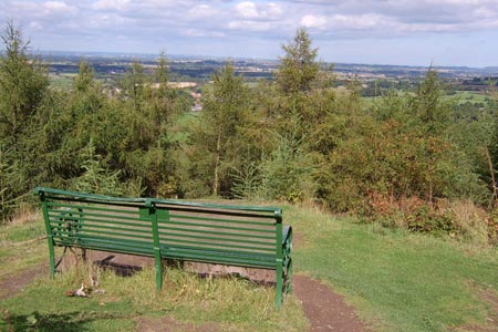
This North York Moors walk gives great views of Black Hambleton, Upper Ryedale, Osmotherley Moor and Oakdale as well as marking the point, in South Wood above Osmotherley, where the Coast to Coast path and the Cleveland Way part company, having been one and the same since Bloworth Crossing. Parking at Square Corner (grid ref. SE479959) is limited and popular but there are plenty of other opportunities on the verges at either side of the official off-road parking.
After parking, walk south east along the road passing a bridleway on your right then take the shooters track on you left, stepping over the low vehicle bar. The track is well defined as it heads northwards across the moor past Miley Pike with other tracks joining from right then left as you keep straight on towards the Swainby Shooting House, which is clearly visible on Rye Head.
Take the left hand path after the shooting house, which goes in front of a row of grouse butts. After butt No 3, take the track off left along Stony Ridge and continue to the corner of Clain Wood (grid ref. SE487997). There is now a section of pathless moorland to cover keeping the edge of Clain Wood to your right. After 800 metres you reach a track (grid ref. NZ480002) which is followed across Whorlton Moor for a further 600 metres to reach a left hand bend (grid ref. NZ475000). Here turn right onto a footpath and follow this down to a road (grid ref. NZ471000).
Cross the road onto a track heading roughly north. This soon joins the Cleveland Way. Turn left along the edge of Scarth Wood Moor. The path then skirts the edge of and then descends through South Wood. The trees are a reasonable way from the path so it does not feel, as sometimes it can, like an oppressive section of woodland walking. As you come out of the wood the Coast to Coast path joins from your right, on its way to Bloworth Crossing.
Continue straight on to Chapel Wood Farm, then take the farm track to the left that goes uphill before bending to the left and then descending through houses to the road to Osmotherley. Go right on the road down into the village and, at the War Memorial in the centre, go through the passage between the house on your right which is way-marked with an acorn marker and signposted to the Methodist Church.
At the end of this passage bear right at the end, cross the road and take another fenced passage between gardens then fields as you are corralled down Middlestye Bank and across the Cod beck. Coming up the other side you cross the track to Middlestye Farm, go around Whitehouse Farm then turn right on Green Lane and continue on to the road.
Turn left on the road, then right off on the track into the Thimbleby Estate, which is signposted to Black Hambleton. In Oak Dale there is considerable Yorkshire Water work on the upper reservoir until 2015. There was no water in it at September 2014 so it is a little hard to say where it would have ended but look for the small footbridge over Jenny Brewster's Gill which should be down to your right. Go over the footbridge then climb up the path at the side of Jenny Brewster's Spring back to Square Corner.
Other walks nearby
| Walk 3718 | Scarth Wood Moor from Osmotherley | easy/mod | 6.0 miles |
| Walk 1622 | Hawnby, Bilsdale West and Wetherhouse Moors | moderate | 8.3 miles |
| Walk 3418 | Cringle Moor & the Wain Stones | easy/mod | 6.0 miles |
| Walk 1469 | Carlton Bank, Scugdale, Raisdale & Kirby Bank | moderate | 10.5 miles |
| Walk 1544 | Chop Gate, Round Hill & Stumps Cross | moderate | 10.1 miles |
| Walk 1468 | Wain Stones, Bank Foot & Bloworth Crossing | moderate | 14.3 miles |
| Walk 1524 | Cold Kirby, Rievaulx Bridge & Wass | moderate | 12.5 miles |
| Walk 3581 | Gormire Lake from Sutton Bank National Park Centre | easy/mod | 3.4 miles |
| Walk 1498 | Kilburn White Horse, Cold Kirby, Murton, & Sutton Bank | moderate | 14.0 miles |
| Walk 1920 | Rievaulx Moor from Cowhouse Bank | moderate | 9.5 miles |
Recommended Books & eBooks
The Cleveland Way Map Booklet
 Map booklet of the Cleveland Way National Trail, a 177km (110 mile) walk around the North York Moors National Park. This booklet is included with the Cicerone guidebook to the Cleveland Way and the Yorkshire Wolds Way, and shows the full route of the Cleveland Way on Ordnance Survey 1:25,000 maps.
More information
Trail and Fell Running in the Yorkshire Dales
 Guidebook to 40 of the best trail and fell runs in the Yorkshire Dales National Park. Ranging from 5 to 24 miles, the graded runs start from bases such as Ribblehead, Dent, Sedbergh, Malham and Grassington and take in the region's diverse delights, from castles and waterfalls to iconic mountains such as Whernside, Ingleborough and Pen Y Ghent.
More information
Messaging & Social Media
Message Walking Britain and follow the latest news.

Mountain Weather
Stay safe on the mountains with detailed weather forecasts - for iOS devices or for Android devices.