Boulby Mine to Whitby by the Cleveland Way
North York Moors Walk
Nat Park - North York Moors - North York Moors East
County/Area - North Yorkshire
Author - Andy Chaplin
Length - 12.5 miles / 20.3 km Ascent - 1500 feet / 455 metres
Time - 7 hours 50 minutes Grade - moderate
Maps 

| Ordnance Survey Explorer OL27 | Sheet Map | 1:25k | BUY |
| Anquet OS Explorer OL27 | Digital Map | 1:25k | BUY |
| Ordnance Survey Landranger 94 | Sheet Map | 1:50k | BUY |
| Anquet OS Landranger 94 | Digital Map | 1:50k | BUY |
Walk Route Description
Click image to see photo description.
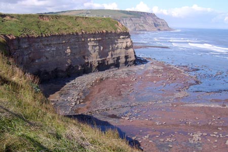
This is a one-way walk going south along the North Sea coast on the Cleveland Way in the North York Moors National Park. There are all the fine views that you would expect from a coastal path that follows the cliffs and bays north of Whitby. There are also interesting sections through Staithes, Runswick Bay, Port Mulgrave and Sandsend. Walking one-way is possible because of the regular bus service from Whitby to Loftus - Arriva No 4 which goes every 30 minutes on weekdays and Saturdays and hourly on Sundays and Bank holidays. The fare to Boulby from Whitby (2014) was £ 5 for a full fare single ticket. Stay on the bus through Staithes and get off opposite the entrance to Boulby Mine. At this point the road and Cleveland Way are very close.
Pick up the Cleveland Way at Boulby Grange then follow it across the field until you reach the cliff track (in places it is diverted where it has disappeared over the cliff) that joins up with Cowbar Lane before descending down into Staithes. Cross over the river on the footbridge then go down past the Cod & Lobster, along the beach front and off right, up the road which has the Staithes Art Centre about half way up on the right.
The Cleveland Way is then way-marked as you reach the end of this road. Take the path going up on the left as two paths diverge and keep climbing up until you are walking above Old Nab. The cliff path continues to Port Mulgrave where it picks up the Rosedale Road for a while before leaving it again at an information board about mining at Port Mulgrave. At Runswick Bay the path comes out at the side of the Runswick Bay hotel. Turn left along the road towards the Cliff Mount Hotel (which also passes the public toilets in the car park to your right) then follow the way down back to the main road which leads to the beach.
Walk along the beach past the sailing club and look for the stepped path leading up at the side of the stream after about 0.5 kilometre of walking along the beach. It starts off being quite slippery and ends up being steep and gruelling, but when you get back on the cliff tops at High Cliff there is a bench to sit and admire the view. Continue along the top to Kettleness and keep to the left of the farm until you briefly join a road. Then turn off left on the cliff path again. You pass at the side of the old railway tunnel and continue along the top until steep stone and wooden steps take you down into the end of Over Dale where the other end of the tunnel comes out.
From here it is a walk along the old railway route into Sandsend where the path comes out in the car park below Lythe Bank. You walk along the road to cross Sandsend Beck and then the Cleveland Way continues on the main road to a track leading to the shore after the Whitby Golf Club House. If the tide is out it is a much better walk to get down on the beach and walk all the way to the West Pier in Whitby - but beware, the tide comes all the way in on much of the beach and it is soil cliffs at Upgang Beach and rock cliffs at Whitby Sands.
Other walks nearby
| Walk 2090 | Easington Beck & Staithes from Loftus | moderate | 11.5 miles |
| Walk 1841 | Saltburn and Skelton from Skinningrove | moderate | 10.4 miles |
| Walk 3532 | Runswick Bay to Staithes | easy | 3.8 miles |
| Walk 1887 | Runswick Bay & Kettleness | moderate | 9.0 miles |
| Walk 1452 | Leaholm Moor & Scaling Dam | moderate | 9.8 miles |
| Walk 2174 | Warsett Hill from Saltburn-by-the-Sea | easy | 4.3 miles |
| Walk 2091 | Kettleness and Mickleby from Lythe | moderate | 9.7 miles |
| Walk 1012 | Glaisdale, Great Fryup Dale and Eskdale | moderate | 7.5 miles |
| Walk 3737 | Commondale & Esk Valley | easy/mod | 8.2 miles |
| Walk 1450 | Little & Great Fryup Dales | moderate | 8.3 miles |
Recommended Books & eBooks
The Cleveland Way Map Booklet
 Map booklet of the Cleveland Way National Trail, a 177km (110 mile) walk around the North York Moors National Park. This booklet is included with the Cicerone guidebook to the Cleveland Way and the Yorkshire Wolds Way, and shows the full route of the Cleveland Way on Ordnance Survey 1:25,000 maps.
More information
Trail and Fell Running in the Yorkshire Dales
 Guidebook to 40 of the best trail and fell runs in the Yorkshire Dales National Park. Ranging from 5 to 24 miles, the graded runs start from bases such as Ribblehead, Dent, Sedbergh, Malham and Grassington and take in the region's diverse delights, from castles and waterfalls to iconic mountains such as Whernside, Ingleborough and Pen Y Ghent.
More information
Messaging & Social Media
Message Walking Britain and follow the latest news.

Mountain Weather
Stay safe on the mountains with detailed weather forecasts - for iOS devices or for Android devices.