Dale Top (Park Moor) from Lyme Park
Peak District Walk
Nat Park - Peak District - Goyt Valley Lyme Park
County/Area - Cheshire
Author - Lou Johnson
Length - 6.3 miles / 10.2 km Ascent - 650 feet / 197 metres
Time - 3 hours 50 minutes Grade - easy
Maps 

| Ordnance Survey Explorer OL1 | Sheet Map | 1:25k | BUY |
| Anquet OS Explorer OL1 | Digital Map | 1:25k | BUY |
| Ordnance Survey Landranger 109 | Sheet Map | 1:50k | BUY |
| Anquet OS Landranger 109 | Digital Map | 1:50k | BUY |
Walk Route Description
Click image to visit gallery of 9 images.
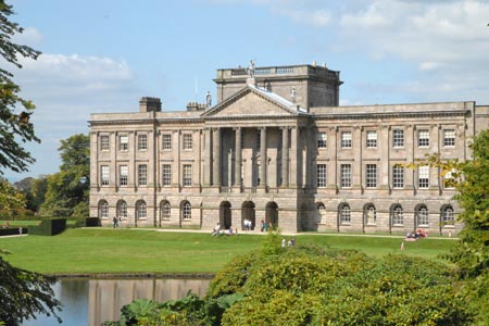
Lyme Park Country Park with its grand stately home, Lyme Hall, is a popular place for visitors. Owned by the National Trust an entrance fee is payable for parking. On arrival you will normally receive a map of the estate which is a useful reference for this walk, although the map does not contain the complete route. It does provide detailed guidance within the estate boundary.
It is assumed that you start this Peak District walk from the main car park (grid ref. SJ9628240). However at busy times you may be directed to other parking areas nearby. Toilets and refreshments are a few minutes' walk from this main car park. Having parked follow the tarmac road heading roughly west towards the Knott, where there is a further car park. Bear right off the road and follow the path alongside a stream through Pursefield Wood to reach a track close to West Parkgate (grid ref. SJ949815).
Once through the gates bear right and continue to a lane (grid ref. SJ948814). After a few metres take the track on your right. This leads you uphill towards Moorside after which you bear right to join Moorside Lane. Continue in a southwesterly direction to Keeper's Cottage (grid ref. SJ954805). Go left here following the path uphill alongside a dry stone wall on your left to reach a stile in the fence at the top.
Cross the stile and following the path/track ahead through a gate and stile without a wall or fence attached! This leads you alongside the wall, which is on your left. The way ahead is clear and there are some good views across the Lyme Park Estate on your left. The track leads you to another track near to where the wall turns sharply left (grid ref. SJ971807). Bear left along this track which is part of the Grtstone Trail. The views to Kinder Scout on your right are good.
Reaching a junction of paths (grid ref. SJ973812), turn left and enter National Trust property again. After passing through the gate, bear immediately right and follow the path up beside the wall to reach a topograph from where you have a grand view west towards the Manchester area. After enjoying the view return back to the Gritstone Trail, turn right and walk downhill on the clear path back to the car park.
Having completed the moorland section of walk, the route continues from the car park to follow the perimeter fence on the south side of the Lyme Hall. You get some good views of the stately house on this section. Reaching a junction of paths at Hampers Bridge, turn left and follow this clear path towards the main frontage of the Hall. You will see "The Cage" appear ahead and make a beeline for the path that leads to this fine vantage point. After taking in the view, return down the main path leading from The Cage and return to the main car park.
Other walks nearby
| Walk 2523 | Black Rocks & Bollinhurst Reservoir | easy | 5.0 miles |
| Walk 2567 | Lyme Park & Dissop Head | easy | 6.0 miles |
| Walk 2528 | Kettleshulme & Sponds Hill | moderate | 8.0 miles |
| Walk 2557 | Lyme Park from Poynton | moderate | 10.0 miles |
| Walk 2622 | Sett Valley & Kinder from New Mills | moderate | 10.0 miles |
| Walk 2605 | White Nancy & Saddle of Kerridge Nr Bollington | easy | 4.5 miles |
| Walk 3588 | Rainow Circular | easy/mod | 5.5 miles |
| Walk 1233 | Shining Tor & Windgather Rocks | moderate | 7.5 miles |
| Walk 2527 | Kettleshulme & Taxal Edge from Lamaload | moderate | 10.0 miles |
| Walk 2534 | Chinley Churn & South Head | easy/mod | 7.5 miles |
Recommended Books & eBooks
Great Mountain Days in the Pennines
 An inspirational guidebook to 50 classic walks on the rolling Pennine landscape. The graded routes, between 6 and 13 miles in length, cover classic Pennine fells and moorland such as Whernside, Ilkley Moor and Pendle Hill; exploring the North and South Pennines, Yorkshire Dales, Howgills and Dark Peak. Many routes are also suited to fell running.
More information
Dark Peak Walks
 Guidebook to 40 walks in the Dark Peak area of the Peak District National Park. 35 circular routes for most abilities, from 8km to 19km, around Edale, Marsden, Fairholmes, Baslow and Castleton, including Kinder Scout and Mam Tor, and 5 longer (25km to 45km) routes highlighting the best of the Gritstone Edges, High Moorland and Deep Valleys.
More information
Messaging & Social Media
Message Walking Britain and follow the latest news.

Mountain Weather
Stay safe on the mountains with detailed weather forecasts - for iOS devices or for Android devices.