Middleton-in-Teesdale Railway Walk
North Pennines Walk
Region - North Pennines
County/Area - Durham
Author - Steven Wallace
Length - 2.5 miles / 4.1 km Ascent - 250 feet / 76 metres
Time - 1 hours 30 minutes Grade - easy
Maps 

| Ordnance Survey Explorer OL31 | Sheet Map | 1:25k | BUY |
| Anquet OS Explorer OL31 | Digital Map | 1:25k | BUY |
| Ordnance Survey Landranger 91 | Sheet Map | 1:50k | BUY |
| Anquet OS Landranger 91 | Digital Map | 1:50k | BUY |
| Ordnance Survey Landranger 92 | Sheet Map | 1:50k | BUY |
| Anquet OS Landranger 92 | Digital Map | 1:50k | BUY |
Walk Route Description
Click image to visit gallery of 4 images.
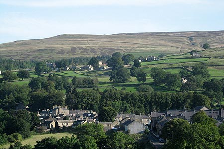
This walk from Middleton-in-Teesdale starts from the Market Place. From here, walk down Bridge Street and cross the old county bridge over the River Tees. Built in 1811, it used to mark the boundary between the counties of Durham and Yorkshire. Walk up the hill until you come to the first road off to the right - signposted Holwick. Turn right and walk to the end of the house on the corner. To your left you will see a footpath sign for the Pennine Way through a wooden gate. Follow this path up a steep slope for about 20 yards and then turn right along a permissive path on an old railway line. This line, opened in the early 20th century by the North Eastern Railways operated until 1951 and was used to transport stone form the quarries of Park End and Crossthwaite to Middleton and from there on to Darlington. Follow the old track for about a mile. It is easy walking and gives beautiful views to the north of the Tees Valley and fells between Newbiggin and Middleton and to the northwest of Holwick Scars and beyond.
On reaching a dry stone wall ahead, turn right down a feint path, keeping close to the wall, until you reach a gate out onto the road at the bottom. Turn left along the road for about 200 yards until you see a footpath sign off to the right through a wooden gate. Once through the gate make your way straight ahead towards a bridge over a stream and having crossed turn right. Now walk to the gateway ahead. Keep on the same line across a second field to find a stile near the far corner. On crossing the stile you will be alongside the stream once more . Follow the bank of the stream through the field and most of the next one, until the path leads up to a track by a stone barn. This is the Pennine Way. Continue along the track to the end off the field and on through the next two until you come out on the road at Middleton. Turn left, crossing the bridge and climbing back up the hill into the village until you reach the Market Place.
Other walks nearby
| Walk 2228 | Romaldkirk Moor | easy/mod | 7.6 miles |
| Walk 3099 | High Force, Low Force and the River Tees | easy/mod | 7.5 miles |
| Walk 2157 | Romaldkirk & Cotherstone | easy | 5.0 miles |
| Walk 2170 | Eggleston & Mickleton from Romaldkirk | easy/mod | 5.8 miles |
| Walk 1553 | Hannah's Meadow, Baldersdale & Brown Rigg Moss | easy/mod | 8.0 miles |
| Walk 3424 | Cronkley Fell from Hanging Shaw | easy/mod | 7.0 miles |
| Walk 3526 | Hanging Shaw, Cronkley Scar, Low Force & High Force | moderate | 12.7 miles |
| Walk 3634 | Catterick Moss & Bollihope Carrs | moderate | 5.6 miles |
| Walk 2469 | Great Allotment & God's Bridge | moderate | 10.2 miles |
| Walk 2393 | Weardale Circular from Westgate | easy/mod | 6.4 miles |
Recommended Books & eBooks
Pennine Way Map Booklet
 Map of the 270 miles (435km) Pennine Way National Trail, between Edale in the Peak District and Kirk Yetholm in the Scottish Borders. This booklet is included with the Cicerone guidebook to the trail, and shows the full route on Ordnance Survey 1:25,000 maps. This popular long-distance route typically takes three weeks to complete.
More information
The Pennine Way
 Guidebook to the Pennine Way National Trail with OS map booklet. The 265 mile route from Edale to Kirk Yetholm takes three weeks to walk and is suitable for fit and experienced long distance walkers. The route crosses the Peak District, Yorkshire Dales and North Pennines National Parks. Includes separate OS 1:25,000 map booklet of the route.
More information
Messaging & Social Media
Message Walking Britain and follow the latest news.

Mountain Weather
Stay safe on the mountains with detailed weather forecasts - for iOS devices or for Android devices.