WHW - Day 5 - Inveroran to Kinlochleven
Argyll and Bute Walk
County/Area - Argyll and Bute & Highland
Author - Peter Smyly
Length - 19.0 miles / 30.9 km
Ascent - nominal or unknown
Time - 9 hours 30 minutes Grade - moderate
Maps 

| Ordnance Survey Explorer 384 | Sheet Map | 1:25k | BUY |
| Anquet OS Explorer 384 | Digital Map | 1:25k | BUY |
Walk Route Description
Click image to visit gallery of 3 images.
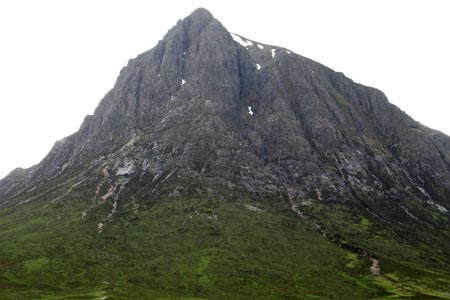
On setting off today, it was a relief to escape from swarms of midges as, with a backdrop of distant mountains, the main road away from the Inveroran Hotel led past fields and over Victoria Bridge. Loch Tulla is seen briefly from the bridge but it disappears behind tree cover after that and the best view of it turns out to have been the one looking down on it the previous day. The Old Military Road passes a few tree plantations and then a sizeable, though shallow, lochan that forms a pleasant foreground to distant peaks. There were views of mountains with snow patches rising above coniferous forests beyond moorland on the left. Ba Bridge over the River Ba presents some picturesque rock formations in the river and this area is known as the Black Mount. Rannoch Moor, however, is too far away to make a clear impression this time with just a distant glimpse of it's lakes. Buachaille Etive Mor, one of Scotland's best-known peaks, stands sentinel at the head of Glencoe and looked as impressive as ever with its giant pyramid-like appearance and massive cliffs. It would not look out of place in the French Alps.
After crossing the busy A82, most WHW walkers stop at the Kings House Hotel, with its climbers' bar, a popular refreshment stop, given the hotel's isolated position from any similar amenities. The path reaches the main road through Glencoe briefly before heading up the Devil's Staircase, a grand name for a stony path that winds its was up heathery slopes to the skyline to reach the highest point on the WHW (548 metres) before continuing down the other side. The Mamores range with "The Ben" (Ben Nevis) which is often in cloud, cloud-free this time, were in view ahead in the distance while to the right, the Blackwater Reservoir could be glimpsed, looking rather grey as on previous occasions I had seen it. There is s still a lot of height to be lost as the path drops down, very steeply at times in the latter stages, through woodland, to Kinlochleven. As the long descent unfolded, the crowds of walkers at the top of the Devil's Staircase had soon disappeared in their quest to race on ahead to Kinlochleven.
Click here to continue to part 6
Other walks nearby
| Walk 1865 | Loch Dochard (near Bridge of Orchy) | easy/mod | 8.5 miles |
| Walk 2491 | Old Military Road from Victoria Bridge | easy/mod | 6.5 miles |
| Walk 1019 | Beinn an Dothaidh & Beinn Dorain | moderate | 8.5 miles |
| Walk 3277 | Beinn Dorain | mod/hard | 6.2 miles |
| Walk 3273 | Ben Starav | hard | 8.0 miles |
| Walk 1879 | Ben Starav & Glas Bheinn Mhor` | hard | 10.0 miles |
| Walk 3010 | Stob Dearg (Buachaille Etive Mor) from Altnafeadh | mod/hard | 4.0 miles |
| Walk 3269 | The Munros of Buachaille Etive Mor | mod/hard | 8.2 miles |
| Walk 2819 | Stob na Broige, Buchaille Etive Mor, Glen Coe | mod/hard | 6.1 miles |
| Walk 2808 | Buachaille Etive Beag, Glen Coe | hard | 9.0 miles |
Recommended Books & eBooks
West Highland Way Map Booklet
 This compact booklet of maps shows the full route of the 95 mile West Highland Way Scottish Long Distance Route, via Loch Lomond and Rannoch Moor. This booklet is included with the Cicerone guidebook to the trail, and shows the full route on Ordnance Survey 1:25,000 maps.
More information
The West Highland Way
 Guidebook to walking the West Highland Way National Trail, a 95 mile Scottish long-distance route from Milngavie near Glasgow to Fort William, passing Loch Lomond and crossing Rannoch Moor. Suggested itineraries over 6 to 9 days. Includes accommodation guide and pull-out 1:25K OS map booklet.
More information
Messaging & Social Media
Message Walking Britain and follow the latest news.

Mountain Weather
Stay safe on the mountains with detailed weather forecasts - for iOS devices or for Android devices.