Walk 1528 - printer friendly version
Moel Famau Walk
Author - Lou Johnson
Length - 10.0 miles / 16.3 km
Ascent - 1200 feet / 364 metres
Grade - easy/mod
Start - OS grid reference SJ161605
Lat 53.135027 + Long -3.2555406
Postcode LL15 1UR (approx. location only)
Moel Famau is one of my favourite summits in the Clwydian Hills as it offers (in fine weather!) a superb panorama west towards the high mountains of Snowdonia (Eryri). There is a downside as the hill attracts many people in good weather and the direct route of ascent from the car park can be very busy. This walk takes a less direct route in ascent avoiding the busy path and also provides a closer look at the valley lying on the western flank of the Clwydian Hills.
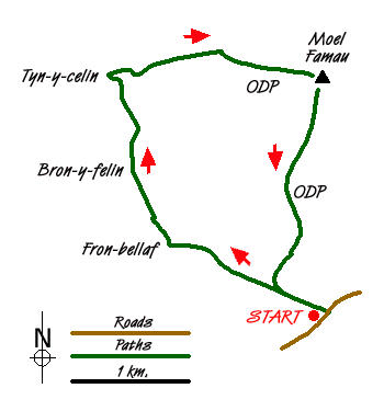
The start is the car park (grid ref. SJ161605) at Bwlch Penbarra. Exit the car park and take the Offa?s Dyke National Trail north towards Moel Famau. Where the main path to Moel Famau turns right (grid ref SJ156607) bear left on a less distinct path that descends to Fron-bellaf. Initially the path follows a wall which is on your left. As you descend the path turns northwest crossing another wall before descending more steeply to reach a track.
Turn right along the track for a short way before turning left to reach another track (grid ref. SJ146612). Cross the stream and where the track divides keep right and continue following the marked path to reach another track (grid ref. SJ143618) just before Bron-y-felin. Turn right along this track following the footpath diversion around Bron-y-felin to rejoin the track as it crosses a small stream. A short way after the stream, turn right uphill (grid ref. SJ142620) to enter open country.
Once in open country, turn left along the path with the wall on your left and continue until your are level with a track by Tyn-y-celin (grid ref. SJ141627). In a few metres an ascending path goes right ? take this and climb, quite steeply in places, across the hillside eventually meeting the Offa?s Dyke Path (grid ref. SJ151629). Turn right and continue to the summit of Moel Famau with the Jubilee Tower usually attracting a crowd. Nearby is the trip point at 554 metres above sea level.
All the hard work has been completed and it's now time to enjoy the view. On a clear day you can clearly identify many of the summits in Snowdonia (Eryri). After taking in the view all that remains is a gentle amble downhill to the car park at Bwlch Penbarra.
Messaging & Social Media
Message Walking Britain and follow the latest news.

Mountain Weather
Stay safe on the mountains with detailed weather forecasts - for iOS devices or for Android devices.