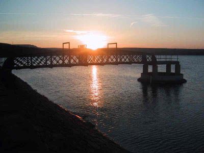
Blackmoorfoot Reservoir
West Yorkshire Walk
County/Area - West Yorkshire - Kirklees
Author - Yorkshire Water
Length - 1.5 miles / 2.4 km Ascent - 100 feet / 30 metres
Time - 0 hours 50 minutes Grade - easy
Maps 

| Ordnance Survey Explorer OL21 | Sheet Map | 1:25k | BUY |
| Anquet OS Explorer OL21 | Digital Map | 1:25k | BUY |
Walk Route Description
Click image to see photo description.
Located south-west of Huddesfield this easy walk follows the shores of Blackmoorfoot Reservoir. It is an easy walk and should be completed in less than an hour. The walk should provide evidence of the local wildlife and during certain times of the year you should also see plenty of evidence of migrating birds.
This is one of the free reservoir walks produced by Yorkshire Water who are one of the county's largest landowners, with around 72,000 acres of land spanning National Parks, Areas of Outstanding Natural Beauty, the North York Moors and the Yorkshire Wolds. There is a wide range of walks on offer from gentle strolls around one of their picturesque reservoirs to more adventurous routes. Yorkshire Water have selected some of their top walks for you and split them into three regional packs. Just print them out and off you go.
Each site has its own walk pack that you can easily print out and take along with you. Each pack includes directions to the site, a summary of the walk, a list of facilities available, a detailed route map and route instructions. To download walk descriptions go to Yorkshire Water Walks.
Other walks nearby
| Walk 2719 | Huddersfield's green fringe | easy/mod | 10.0 miles |
| Walk 2359 | Cuckoo Walk & Bacon Butties from Marsden | hard | 19.5 miles |
| Walk 2644 | Marsden and the Standedge Trail | moderate | 11.0 miles |
| Walk 2926 | Cupwith & Shooter's Nab from Marsden | moderate | 13.0 miles |
| Walk 2946 | Buckstones and Linsgreave Head from Marsden | moderate | 8.8 miles |
| Walk 3159 | March Haigh Reservoir & Eastergate Bridge from Marsden | easy/mod | 5.0 miles |
| Walk 1900 | Standedge Trail from Marsden | moderate | 9.0 miles |
| Walk 1697 | Marsden to Edale challenge | very hard | 22.0 miles |
| Walk 2098 | Marsden Moor from Marsden | easy/mod | 6.4 miles |
| Walk 2613 | Boundary Walk from Marsden | moderate | 13.0 miles |
Recommended Books & eBooks
No suggestions for this area.Messaging & Social Media
Message Walking Britain and follow the latest news.

Mountain Weather
Stay safe on the mountains with detailed weather forecasts - for iOS devices or for Android devices.