Saunderton circular via Bledlow Ridge
Chilterns Walk
Region - Chilterns
County/Area - Buckinghamshire & Oxfordshire - South Buckinghamshire
Author - Peter Smyly
Length - 11.3 miles / 18.3 km Ascent - 1200 feet / 364 metres
Time - 6 hours 50 minutes Grade - moderate
Maps 

| Ordnance Survey Explorer 171 | Sheet Map | 1:25k | BUY |
| Anquet OS Explorer 171 | Digital Map | 1:25k | BUY |
| Ordnance Survey Landranger 165 | Sheet Map | 1:50k | BUY |
| Anquet OS Landranger 165 | Digital Map | 1:50k | BUY |
Walk Route Description
Click image to visit gallery of 8 images.
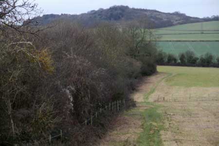
This is a walking route that starts and ends at Saunderton railway station in Buckinghamshire which is on the main Chiltern line between High Wycombe and Princes Risborough. This is essentially a circular route but with an extra loop attached to it from the village of Radnage. This part of the Chilterns is crossed by many public footpaths and bridleways and therefore the walk can be made longer, shorter, or simply different according to one's personal preferences. Typically, the scenery consists of undulating countryside with fields, woodland, hedgerows, low ridges and scattered rural settlements. As is often the case with the Chilterns, there is mud underfoot from time to time, therefore boots are advisable. Gradients are mostly gentle though there are a few relatively steep but short uphill sections. If there is one downside to the walk, it is the occasional need to walk along a narrow country lane, taking care with any traffic, to continue the route along the next public footpath.
From Saunderton station, the first narrow country lane of the walk leads up a hill and, when the road bends sharp left, a public footpath appears to the right. There is a choice of two routes here, but this route takes the diagonal path up the field ahead to reach a line of trees where it turns right. The tree-clad Lodge Hill now appears ahead on the distant horizon and this is the next objective, to be reached by following the path ahead which crosses a road, Haw Lane. On reaching Lodge Hill, the path skirts round the hill to the right to reach a T junction of paths with signposts for the Ridgeway and a left turn up the hill reveals much of the walk thus far to the left.
The path leads through woodland with a distant view to the right of Princes Risborough backed by Whiteleaf Hill with its white cross just visible above some trees. The path emerges into the open briefly along a grassy ridge before going back into woodland, where it goes down quite steeply. When it emerges into the open again, take the next turning to the left across a field through a metal kissing gate. However, before reaching the other side of the field, go left at the next path crossroads, a path which runs parallel, but in the opposite direction to, the path just taken down from Lodge Hill a few minutes earlier. At the next gate ahead, instead of taking the obvious route ahead through the gate, take the less obvious, and much narrower track to the right with a hedgerow on the left, bordering a field.
At the end of the field, the path continues past Callow Down Farm. Following the public footpath signs leads to the left at the next T junction. On rounding a corner to border a field, the grassy ridge between two bits of woodland on Lodge Hill, passed along a few minutes earlier, comes into view. Next follow the path ahead to go through Neighbour's Wood, passing the houses of Rout's Green on the way to Chinnor Road, quite a busy road that needs crossing with care. On the other side of this road, a narrow path with hedgerow on the left and a fence on the right, leads downhill to reach Radnage Lane. This is a narrow country lane where it is necessary to follow the road, mindful of any traffic, for a few hundred yards into Radnage. At Radnage, St Mary's Church is off a lane to the left but the waymarked path continues right through a wooden gate and across a field. This point is where the extra loop comes in; however, one could cut the walk short and head back to the start point from here instead.
At the other side of the field, walk right along Sprigs Holly Lane for a short distance before taking the next turning to the right for the Bledlow Circular Ride, initially along a tarmac secondary road towards Daws Hill Farm, leading to a footpath, muddy in places, through woodland off to the left of the road. At Venus Wood there is a crossroads of paths. Turn left up through woodland along one of the few steepish sections of this walk to reach the houses of Sprig's Alley. A few minutes' walk along a narrow country lane to the right leads to the next turning on the left along a public bridleway running past Crowellhill Farm and through Crowell Wood. Although this is a private road to the farm initially, a narrow signposted path off down through the trees to the left of this road is the way to go next. Painted white arrows on trees indicate the way ahead through woodland, although the path is clear enough anyway. The route emerges into the open at Grange Farm and continues along another country lane until the next turning left along a narrow path up a sloping field, reveals a fine view to the north-west of hills and trees. At the top of the sloping field, the gradient eases off as the path continues ahead to Andridge Farm.
At the farm, ignore the road to the left, but take the road ahead through the farm. Confirmation that this is a public right of way comes in the form of a public footpath sign ahead as you leave the farm buildings at the top of a sloping field. The path now borders a hedgerow on the left to skirt the field as it goes downhill and the view ahead, overlooking Radnage, and the wooded ridge beyond, ranks as one of the better views of the whole walk.
At the bottom of the field, the path crosses two wooden stiles in quick succession to emerge on a secondary road. Turn left here and follow the road downhill to a point where it divides with a branch to the left and the right. The field on the left is now the same field which was crossed earlier in the walk, opposite the church at Radnage. Walk along the secondary road to the left for about a hundred yards back towards Radnage and take the first signed public footpath on the right. St Mary's Church soon comes into view on the left. After passing through a wooden gate ahead, this next section is particularly scenic in the context of the walk overall with a wooded ridge ahead and another fine view looking back as you walk up the hill revealing Radnage and its church and wooded ridges beyond. Red kites soaring overhead above the trees of Yousden Wood were particularly apparent at this point of the walk.
The path continues through the woods due north-east to the village of Bledlow Ridge. A right turn along the other side of the main road leads to another signed public footpath on the left going downhill and this is the way to go next. At the bottom of the hill, the path crosses a field and, taking the next right turn brings you back to Haw Lane, passed in the early stages of the walk. It is now about a mile back to the station, reversing the outgoing section of the walk.
Other walks nearby
| Walk 1333 | The Ridgeway around Chinnor | easy/mod | 9.0 miles |
| Walk 2470 | West Wycombe & Bledlow Ridge | moderate | 8.2 miles |
| Walk 1965 | Piddington & Horsleys Green Circular | easy | 4.9 miles |
| Walk 3520 | Princes Risborough circular | easy/mod | 9.5 miles |
| Walk 1138 | The Ridgeway at Chequers | easy/mod | 7.3 miles |
| Walk 2478 | Great Kimble Circular | moderate | 11.2 miles |
| Walk 2398 | Turville Circular | easy | 4.1 miles |
| Walk 1140 | The Ridgeway around Lewknor | moderate | 13.0 miles |
| Walk 2052 | Wendover Woods | easy/mod | 7.0 miles |
| Walk 2420 | The Ridgeway south of Wendover | easy/mod | 7.3 miles |
Recommended Books & eBooks
No suggestions for this area.Messaging & Social Media
Message Walking Britain and follow the latest news.

Mountain Weather
Stay safe on the mountains with detailed weather forecasts - for iOS devices or for Android devices.