Filey, Camp Dale & Hunmanby
Yorkshire Wolds Walk
Region - Yorkshire Wolds
County/Area - North Yorkshire - Yorkshire Wolds
Author - Andy Chaplin
Length - 10.5 miles / 17.1 km Ascent - 670 feet / 203 metres
Time - 6 hours 0 minutes Grade - moderate
Maps 

| Ordnance Survey Explorer 301 | Sheet Map | 1:25k | BUY |
| Anquet OS Explorer 301 | Digital Map | 1:25k | BUY |
| Ordnance Survey Landranger 101 | Sheet Map | 1:50k | BUY |
| Anquet OS Landranger 101 | Digital Map | 1:50k | BUY |
Walk Route Description
Click image to visit gallery of 3 images.
If you have walked the Cleveland Way, you may have started or finished at Filey. So, one down and at least two more to go - as the Yorkshire Wolds Way and the Centenary Way both start from Filey. This walk sets off on the Wolds Way and returns on the Centenary Way. It takes in the agricultural land of the wolds with views from the tops back to the coast south of Filey.
Parking is relatively easy in Filey near to the train station. From here you take the A1039 out south westwards until just before Filey Academy school. The Wolds Way is signed off to the right as it makes it way around the back of the school, over the A165 and onto the road into Muston. The Ship Inn is well worth a detour - but maybe after the walk is completed?
The road out of Muston is not the most pleasant part of the walk as it can be busy and there are no pathways but it is relatively soon before you turn off left across the fields. Keep the fence on your right. The path can be poorly defined but keep going until you go through a hedge and turn left on a farm track. The fields of crops that you walk through are very pleasant as they sway in the breeze in late summer and other parts seem to have been left as wildflower meadows.
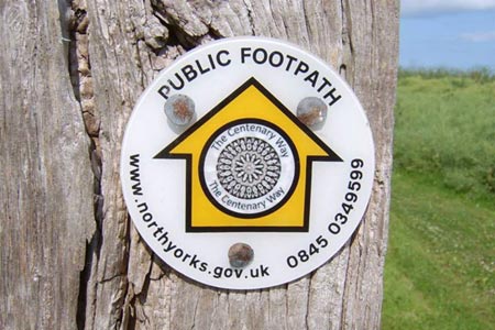
Cross over the road and pass Stockendale Farm. As you bear right down the track keep straight on when it goes left - just in front of a tank with a small way-mark sign on it. The path then goes down Stocking Dale until it meets up with the Centenary Way. Follow the Centenary Way up towards Hunmanby Grange - look out for the blue topped grain-drying structures (maybe?) - and turn off left (where there is a half hidden way-mark) rather than carrying on up the track to the Grange.
As you come past Field House Farm you get a feel for the rolling hills around you and get views to the coast. Join the road and follow it down into Hunmanby, around Castle Hill and off on your left along Northgate. At the end of the road it becomes a track that passes North Moor Farm then heads on to the A165 roundabout.
Take the road off to the Centenary Way camping site and Muston Grange, cross the railway bridge, pass the golf course and head for the cliffs. The path takes you down to the seafront near the paddling pool and you can come back into town on Cargate Hill.
Other walks nearby
| Walk 3247 | Stockingdale and Muston from Hunmanby | easy/mod | 7.8 miles |
| Walk 2482 | Fordon and Dales Circular | easy/mod | 5.2 miles |
| Walk 1631 | Scarborough to Filey | moderate | 10.2 miles |
| Walk 3428 | Boynton from Rudston Circular | easy | 6.5 miles |
| Walk 1564 | Hayburn Wyke from Scalby | moderate | 10.2 miles |
| Walk 2264 | Bridlington & Flamborough Head | easy/mod | 6.8 miles |
| Walk 1620 | Flamborough Head | easy/mod | 9.7 miles |
| Walk 2921 | Bempton Cliffs | easy/mod | 6.7 miles |
| Walk 1395 | Broxa & Broxa Forest | easy/mod | 8.3 miles |
| Walk 2325 | Troutsdale Circular | moderate | 10.1 miles |
Recommended Books & eBooks
The Cleveland Way Map Booklet
 Map booklet of the Cleveland Way National Trail, a 177km (110 mile) walk around the North York Moors National Park. This booklet is included with the Cicerone guidebook to the Cleveland Way and the Yorkshire Wolds Way, and shows the full route of the Cleveland Way on Ordnance Survey 1:25,000 maps.
More information
Trail and Fell Running in the Yorkshire Dales
 Guidebook to 40 of the best trail and fell runs in the Yorkshire Dales National Park. Ranging from 5 to 24 miles, the graded runs start from bases such as Ribblehead, Dent, Sedbergh, Malham and Grassington and take in the region's diverse delights, from castles and waterfalls to iconic mountains such as Whernside, Ingleborough and Pen Y Ghent.
More information
Messaging & Social Media
Message Walking Britain and follow the latest news.

Mountain Weather
Stay safe on the mountains with detailed weather forecasts - for iOS devices or for Android devices.