Scarborough to Filey
North Yorkshire Walk
County/Area - North Yorkshire - Vale of Pickering
Author - Andy Chaplin
Length - 10.2 miles / 16.6 km Ascent - 1200 feet / 364 metres
Time - 6 hours 20 minutes Grade - moderate
Maps 

| Ordnance Survey Explorer 301 | Sheet Map | 1:25k | BUY |
| Anquet OS Explorer 301 | Digital Map | 1:25k | BUY |
| Ordnance Survey Landranger 101 | Sheet Map | 1:50k | BUY |
| Anquet OS Landranger 101 | Digital Map | 1:50k | BUY |
Walk Route Description
Click image to visit gallery of 3 images.
This is a simple walk along the coast with relatively few climbs and descents. It starts with a bus journey from Filey bus station to outside the railway station in Scarborough. In 2015 the East Yorkshire 121 bus service was at least every hour and cost £3.55 one way. Parking on the streets in Filey is relatively easy.
From the train station in Scarborough head off down Westborough then right on Huntriss Row until you are above the South Bay beach near the Grand Hotel. Continue on whatever paths and roads take your fancy along the front towards the Spa and Sun Court Café and then on to the Star Disk at the end of the prom.
Just before a slipway, a little way further on, the Cleveland Way climbs up onto Wheatcroft Cliff and then continues along Frank Cliff. There is now a change to the old route of the Cleveland Way when you have to turn right up onto the Osgodby Hill road before descending again down Tenants Cliff and on towards Cayton Sands.
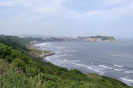
Climbing up to Lebberston Cliff there are good views back to Cayton Bay and then on towards Filey. The Cleveland Way continues along the top of Gristhorpe Cliff alongside the holiday homes overlooking the sea. It is a great view out to sea - a good spot for a holiday home.
It is then an easy walk along Newbiggin Cliff and North Cliff to Filey Brigg where there is a Cleveland Way monument seat. It is worth an out-and-back walk along the Brigg to get a view into Filey Bay then continue along the cliffs back to Filey. You can follow the Yorkshire Wolds Way down to the shore and back up into town or you can stay higher up, go around St Oswald's church and cross on the bridge over the Ravine Road and come back into town.
Other walks nearby
| Walk 1564 | Hayburn Wyke from Scalby | moderate | 10.2 miles |
| Walk 1395 | Broxa & Broxa Forest | easy/mod | 8.3 miles |
| Walk 1630 | Filey, Camp Dale & Hunmanby | moderate | 10.5 miles |
| Walk 3247 | Stockingdale and Muston from Hunmanby | easy/mod | 7.8 miles |
| Walk 2325 | Troutsdale Circular | moderate | 10.1 miles |
| Walk 2482 | Fordon and Dales Circular | easy/mod | 5.2 miles |
| Walk 1744 | Hayburn Wyke & Ravenscar along the Cleveland Way | moderate | 8.5 miles |
| Walk 3471 | Robin Hood's Bay from Ravenscar | moderate | 8.5 miles |
| Walk 1623 | Burn Howe Rigg from Jugger Howes | moderate | 10.0 miles |
| Walk 1867 | Hole of Horcum & Bridestones from Lockton | moderate | 9.8 miles |
Recommended Books & eBooks
The Cleveland Way Map Booklet
 Map booklet of the Cleveland Way National Trail, a 177km (110 mile) walk around the North York Moors National Park. This booklet is included with the Cicerone guidebook to the Cleveland Way and the Yorkshire Wolds Way, and shows the full route of the Cleveland Way on Ordnance Survey 1:25,000 maps.
More information
Trail and Fell Running in the Yorkshire Dales
 Guidebook to 40 of the best trail and fell runs in the Yorkshire Dales National Park. Ranging from 5 to 24 miles, the graded runs start from bases such as Ribblehead, Dent, Sedbergh, Malham and Grassington and take in the region's diverse delights, from castles and waterfalls to iconic mountains such as Whernside, Ingleborough and Pen Y Ghent.
More information
Messaging & Social Media
Message Walking Britain and follow the latest news.

Mountain Weather
Stay safe on the mountains with detailed weather forecasts - for iOS devices or for Android devices.