Arncliffe & Starbotton from Kettlewell
Yorkshire Dales Walk
Nat Park - Yorkshire Dales - Upper Wharfedale
County/Area - North Yorkshire
Author - Lou Johnson
Length - 7.0 miles / 11.4 km Ascent - 1800 feet / 545 metres
Time - 5 hours 20 minutes Grade - moderate
Maps 

| Ordnance Survey Explorer OL30 | Sheet Map | 1:25k | BUY |
| Anquet OS Explorer OL30 | Digital Map | 1:25k | BUY |
| Ordnance Survey Landranger 98 | Sheet Map | 1:50k | BUY |
| Anquet OS Landranger 98 | Digital Map | 1:50k | BUY |
Walk Route Description
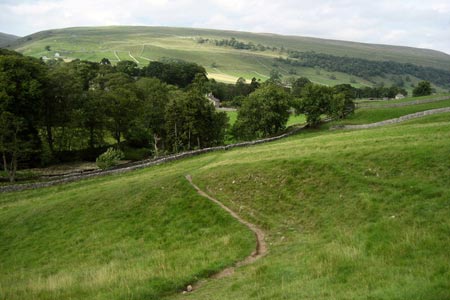
Click image to see photo description.
Kettlewell is a popular starting point for walks in Wharfedale with cafés, pubs and shops. This Yorkshire Dales walk involves considerable ascent first crossing the hills as you walk from Wharefdale to Littondale and then repeating the process as you return to Wharfedale. Thankfully the final section of the walk is a level stroll following the Dales Way alongside the River Wharfe. Refreshments are limited along the way with a pub in Arncliffe the only choice.
There is a pay and display car park in Kettlewell (Grid ref. SD968723) with alternative parking nearby. Leave the car park and cross the River Wharfe. Ignore the riverside path leading to Starbotton and take the next path. Almost immediately turn left on a rising path that can be seen heading uphill to a limestone outcrop. This path is signed Arncliffe. The climb, although steep, offers excellent views of Kettlewell and Wharfedale.
The path is easily to follow and once through the 'slit' in the limestone outcrop the gradient eases to reach Old Cote Moor. With few navigational problems you can enjoy the views with Littondale appearing ahead with Arncliffe village clustered around its church. The descent is easy until you reach Byre Bank Wood where the going is considerably more difficult.
Reaching a tarmac road go straight across to a stile and take the shortcut to the bridge over the River Skirfare. Go over the bridge and explore the village with its pleasant village green and pub. To continue return to the bridge over the River Skirfare and continue ahead to a road T-junction. Opposite you will see the signed footpath to Starbotton. The start is quite steep but you soon join a track which you follow uphill.
The route is never in doubt with good views behind you. As you reach the crest of the hill the views ahead over Wharfedale suddenly open out. Continue across the open fields, descending steadily towards Starbotton. The final section through woodland is steep in places and care is needed after rain. Reaching the footbridge over the River Wharfe you have two options. You can of course cross the river and explore the village. To continue the walk do not cross the bridge instead turn right and follow the Dales Way back to Kettlewell.
Other walks nearby
| Walk 2332 | Mastilles Lane & Bordley from Kilnsey | easy/mod | 6.8 miles |
| Walk 3301 | Conistone to Grassington via the Dib | easy | 5.0 miles |
| Walk 3262 | Copplestone Gate and Conistone Pie from Conistone | easy/mod | 7.0 miles |
| Walk 2423 | Capplestone Gate & Conistone Pie | easy/mod | 6.8 miles |
| Walk 1254 | Yockenthwaite & Hubberholme | moderate | 8.0 miles |
| Walk 1281 | Buckden Pike | moderate | 10.5 miles |
| Walk 2132 | Buckden Pike and Hubberholme | moderate | 8.4 miles |
| Walk 2493 | Cow Close Gill Waterfalls | easy/mod | 5.4 miles |
| Walk 1926 | Pen-y-ghent & Littondale | hard | 16.0 miles |
| Walk 1145 | Grassington, Mastilles Lane & Conistone Dib | moderate | 11.3 miles |
Recommended Books & eBooks
Trail and Fell Running in the Yorkshire Dales
 Guidebook to 40 of the best trail and fell runs in the Yorkshire Dales National Park. Ranging from 5 to 24 miles, the graded runs start from bases such as Ribblehead, Dent, Sedbergh, Malham and Grassington and take in the region's diverse delights, from castles and waterfalls to iconic mountains such as Whernside, Ingleborough and Pen Y Ghent.
More information
Walking in the Yorkshire Dales: North and East
 This guidebook contains 43 circular day walks in the north and east Yorkshire Dales. It explores the dales, hills and moors between Kirkby Stephen and Pateley Bridge. Walking ranges from gentle 3 mile strolls to more strenuous day-long rambles across the Howgills, Wensleydale, Swaledale, Nidderdale, Mallerstang and Coverdale.
More information
Messaging & Social Media
Message Walking Britain and follow the latest news.

Mountain Weather
Stay safe on the mountains with detailed weather forecasts - for iOS devices or for Android devices.