Erwarton, Church End & River Orwell from Pin Mill
Suffolk Walk
County/Area - Suffolk
Author - Lou Johnson
Length - 8.0 miles / 13 km Ascent - 200 feet / 61 metres
Time - 4 hours 10 minutes Grade - easy/mod
Maps 

| Ordnance Survey Explorer 197 | Sheet Map | 1:25k | BUY |
| Anquet OS Explorer 197 | Digital Map | 1:25k | BUY |
| Ordnance Survey Landranger 169 | Sheet Map | 1:50k | BUY |
| Anquet OS Landranger 169 | Digital Map | 1:50k | BUY |
Walk Route Description
Click image to see photo description.
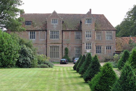
This walk starts on the banks of the River Orwell at Pin Mill where there is a pay and display car park (grid ref. TM205379). The route takes you inland passing Erwarton Hall through Church End to the banks of the Orwell from where you can see Felixstoew Docks. The walk then heads north along the Orwell following the Stout and Orwell Walk.
From the car park walk south along the road towards the centre of Chelmondiston. Take the first footpath on the right. This takes you to the Parish Church and south along Church Street onto the B1456. Cross this road and walk to your right taking the footpath/track on your left. This leads across fields. Where a track comes in from the right keep straight ahead and continue to a T-junction (grid ref TM204368). Go right here and continue to another T-junction where you go left.
Stay on this path to pass Broomfield Covert on your left, turning right towards Crouch House. Go past Crouch House which is on your right and continue ahead, to bear left along Warren Lane (grid ref. TM211359). Continue along Warren Lane until you reach a lane, Erwarton Hall lies just across the road. Bear sharp left here (grid ref. TM223352) to turn north along Erwarton Walk. This leads you to a T-junction with the B1456.
Turn left here, and take the first footpath on the right (grid ref. TM225357). Continue along this path ignoring the path to the left until you reach a T-junction with a track. Turn left here to a lane - Shotley Walk. Turn right along the lane and continue to Church End, where the road turns sharp right (Oldhall Lane at grid ref. TM236360). Keep straight ahead here and continue to a T-junction. Turn right here and continue to the River Orwell.
Turn left onto the Stour and Orwell Walk following the clear path alongside the river (which is on your right). Ignore all footpaths on your left heading inland and continue around the river bank back to the start at Pin Mill. As you get close to Pin Mill you have a choice of routes. Either stay on the Stour and Orwell walk which leads to the road close to the car park or bear right and follow the path along the river.
Other walks nearby
| Walk 2374 | Freston Circular | easy/mod | 6.6 miles |
| Walk 1648 | Church End & Erwarton from Shotley Gate | easy | 6.0 miles |
| Walk 2096 | Alton Water, Stutton & Tattingstone | easy | 5.5 miles |
| Walk 2149 | Circuit of Alton Water | easy/mod | 7.6 miles |
| Walk 3267 | Ramsholt, River Deben and Shottisham Circular | easy/mod | 9.2 miles |
| Walk 3658 | Manningtree, Flatford Mill and Dedham | easy/mod | 7.1 miles |
| Walk 3660 | Stour Valley & Dedham from Flatford Mill | easy | 3.5 miles |
| Walk 2366 | The Naze from Walton-on-the-Naze | easy | 6.0 miles |
| Walk 3724 | River Box from Stoke-by-Nayland | easy | 6.0 miles |
| Walk 2428 | The Rivers Ore & Alde from Orford | easy/mod | 11.0 miles |
Recommended Books & eBooks
Suffolk Coast and Heath Walks
 Guidebook to three long-distance routes exploring the varied landscapes of the Suffolk Coast and Heaths AONB. The Suffolk Coast Path covers 55 to 60 miles from Lowestoft to Felixstowe. The Stour and Orwell Walk is 40 miles from Felixstowe to Cattawade near Manningtree, while the Sandlings Walk is 59 miles from Ipswich to Southwold.
More information
Messaging & Social Media
Message Walking Britain and follow the latest news.

Mountain Weather
Stay safe on the mountains with detailed weather forecasts - for iOS devices or for Android devices.