Walk 1652 - printer friendly version
Three Shires Head Walk
Author - Lou Johnson
Length - 4.5 miles / 7.3 km
Ascent - 700 feet / 212 metres
Grade - easy
Start - OS grid reference SK008699
Lat 53.2261440 + Long -1.9894749
Postcode SK17 0TG (approx. location only)
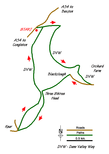
Starting from a small parking area beside the A54 near Danebower Hollow on the A54 Congleton to Buxton Road (grid ref SK008699), this Peak District walk uses sections of once-important packhorse routes as well as other paths. The walk also passes quarries where you can still remnants of their production from many years ago. Route finding is generally good although a 1:25000 map is an asset as there are many paths (some ill-defined) that can cause confusion.
After parking descend down either a path beside the wall or a steeper path closer to the old chimney. At the bottom you, turn left along the Dane Valley Way (the main valley path). This leads through the spoil heaps of Danebower Quarries. Follow the clear path as it drops down to cross a stream. The path then climbs and weaves its way through Reeve-edge Quarries. The track contours across the western flank of the hillside continuing above Blackclough. Stay on the main track as it enters a side valley and continues towards Orchard Farm.
Leave the track before the farm following the Dane Valley Way as it descends to a minor road (grid ref. SK019687). Turn right along this lane continuing downhill to reach a stream in the valley bottom. Cross the stream and continue on the main track heading southwest (with the stream to your left). This leads you to Three Shires Head and Pannier's Pool. Note the pair of attractive packhorse bridges over the infant River Dane and its tributary.
Do not cross the bridge over the Dane, instead turn left over the smaller bridge following the River downstream. This sandy track divides (grid ref. SK009682) where you keep right eventually crossing the River Dane on the approach to Knar. After a short climb up to Knar, take the footpath on your right. This leads across two fields to join a track, which you follow through open country back to Three Shires Head. The onward route does not cross the bridge but follows the Dane Valley Walk north with the river to your right. Initially a track, the way ahead soon becomes a path leading below the farm at Holt to return to the path junction encountered within minutes of leaving the start. Turn left here and it's a short walk uphill following the wall (on your left) to the parking area.
Messaging & Social Media
Message Walking Britain and follow the latest news.

Mountain Weather
Stay safe on the mountains with detailed weather forecasts - for iOS devices or for Android devices.