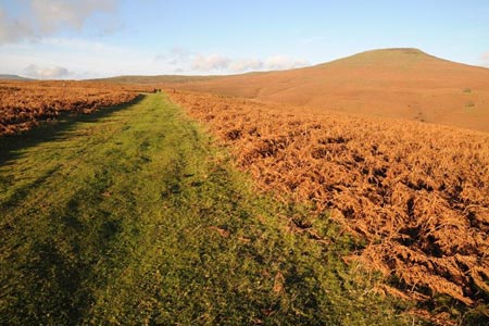
The Sugar Loaf from near Abergavenny
Brecon Beacons/Bannau Brycheiniog Walk
Nat Park - Brecon Beacons - Brecon Beacons East
County/Area - Monmouthshire
Author - Lou Johnson
Length - 3.5 miles / 5.7 km Ascent - 900 feet / 273 metres
Time - 2 hours 40 minutes Grade - easy
Maps 

| Ordnance Survey Explorer OL13 | Sheet Map | 1:25k | BUY |
| Anquet OS Explorer OL13 | Digital Map | 1:25k | BUY |
| Ordnance Survey Landranger 161 | Sheet Map | 1:50k | BUY |
| Anquet OS Landranger 161 | Digital Map | 1:50k | BUY |
Walk Route Description
Click image to see photo description.
The Sugar Loaf dominates the northern aspect of the town of Abergavenny, which rises to 596 metres above sea level. The summit provides excellent panoramas across the south-eastern section of the Brecon Beacons National Park, so you are advised to choose a clear day to do this walk. The ascent and return should take no longer than a couple of hours and would be an ideal route for an evening walk just before sunset.
The start is the small car park at the viewing point (Grid ref. SO268167) reached by a narrow lane from the A40 a few miles west of Abergavenny. (Please note that an overflow parking area has now been provided which is not shown on maps. If using the overflow car park continue to the main parking area to start the walk.) After parking take the clear wide path from the northern side of the parking area that leads north-west. This path takes you past a wall corner from where you get your first view of the main objective of the walk. Trending away from the wall, continue in a north-westerly direction ignoring paths that descend to your right to pick up a double path that leads in a large sweep to the summit of the Sugar Loaf.
During the approach to the Sugar Loaf it does look like a loaf, however despite appearances, the summit is a minor ridge with a fairly steep drop to the north and if you have children then some care is needed. The view amply compensates for the effort climbing the hill. There is a 360 degree panorama across the River Usk to the south and into the heart of the Brecon Beacons to the northwest.
After enjoying the view and exercise all that remains is to trace your steps back to the start.
Other walks nearby
| Walk 3717 | Table Mountain from Crickhowell | easy/mod | 5.0 miles |
| Walk 2670 | Ysgyryd Fawr (The Skirrid) near Abergavenny | easy/mod | 3.5 miles |
| Walk 3435 | Keeper's Pond & Blorenge | easy/mod | 7.5 miles |
| Walk 3134 | The Llangatwg Escarpment from near Crickhowell | moderate | 6.5 miles |
| Walk 1415 | Iron Mountain Trail - 'Llwybr Mynydd Haearn' - Part 1 | easy/mod | 7.5 miles |
| Walk 1512 | Iron Mountain Trail - 'Llwybr Mynydd Haearn' - Part 2 | easy/mod | 5.0 miles |
| Walk 1237 | Cwmyoy & Hatterrall Hill from Llanthony Priory | moderate | 10.0 miles |
| Walk 3203 | Vale of Ewyas from Llanthony Abbey | moderate | 10.7 miles |
| Walk 3342 | The Hatterall Ridge from Llanthony Priory | very hard | 10.0 miles |
| Walk 3622 | Llanthony Priory from Longtown | mod/hard | 7.0 miles |
Recommended Books & eBooks
Walking in Carmarthenshire
 Guidebook to 30 walking routes (2 to 10 miles) in Carmarthenshire, south Wales, including sections of Carmarthenshire Coast Path. Walks for all abilities, including coastal, river, forest and hill walks in Cambrian Mountains, Tywi Valley, Y Mynydd Du (Black Mountains) and Brecon Beacons. Easy access from Bristol, Cardiff and Swansea.
More information
Walking on the Brecon Beacons
 45 circular day walks are described in this guidebook to the Brecon Beacons National Park. From west to east, Mynydd Du, Fforest Fawr, the Brecon Beacons and the Black Mountains these mountain and valley routes offer many options, highlighting the natural features. The walks described explore dramatic waterfalls, wooded gorges and upland valleys.
More information
Messaging & Social Media
Message Walking Britain and follow the latest news.

Mountain Weather
Stay safe on the mountains with detailed weather forecasts - for iOS devices or for Android devices.