Anstey Gate & Hawkridge from Tarr Steps
Exmoor Walk
Nat Park - Exmoor
County/Area - Somerset & Devon
Author - Lou Johnson
Length - 8.2 miles / 13.3 km Ascent - 1400 feet / 424 metres
Time - 5 hours 30 minutes Grade - moderate
Maps 

| Ordnance Survey Explorer OL9 | Sheet Map | 1:25k | BUY |
| Anquet OS Explorer OL9 | Digital Map | 1:25k | BUY |
| Ordnance Survey Landranger 180 | Sheet Map | 1:50k | BUY |
| Anquet OS Landranger 180 | Digital Map | 1:50k | BUY |
Walk Route Description
Click image to see photo description.
This circular Exmoor walk starts from the car park above Tarr Steps (grid ref. SS872323) and includes a landscape of rolling steep sided hills dotted with small farms but doesn't include any moorland as one might expect from this National Park. The route uses a mixture of paths, bridleways and quiet country lanes and navigation is generally easy. Do be prepared for some sections of ascent as the landscape is crossed by some deep valleys. Refreshments are available close to the Tarr Steps.
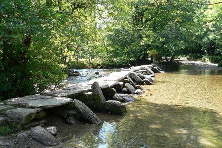
Exit the car park and turn left downhill to the Tarr Steps. There is some controversy regarding their date of construction with various theories being proposed. Despite this the stepping stones remain a popular spot with visitors. Cross the steps and follow the lane for a short distance. Do not take the path on your right running north on the west bank of the River Barle, instead continue a little further to take the next path/bridleway on your right that leads uphill with woodland to your left to reach Parsonage Farm (grid ref. SS857320). Continue through the far, following the footpath that veers right leading up to Hill Farm and a road (grid ref. SS845319).
Go left along the road until the junction (Withypool Cross) where you turn sharp right. Turn left down the access track to just before Cloggs Farm where the bridleway goes left, drops down into a side valley and climbs up to a path/bridleway junction (grid ref. SS841310). Turn right here and follow the path down into a valley, across a footbridge and an ascent up to Lyshwell where the path keeps to the left of the buildings to join an access track. Follow this access track as it drops down into another valley before climbing up to reach a road at Anstey Gate (grid ref. SS834298) on Brimblecombe Hill.
Turn left along the road across West Anstey Common and continue for almost exactly a mile. At grid ref. SS848292 take the bridleway on the left which descends across the western flank of Anstey Money Common to reach a lane (grid ref. SS857300). Turn left along the lane, cross Dane's Brook and climb out of the valley along Slade Lane. The lane bear right and then turns sharp left - at this point (grid ref. SS855303), take the footpath on the right which leads across a field to West Hollowcombe.
Continue straight ahead here, and passing East Hollowcombe, walk along the lane into the centre of Hawkridge. At the road junction bear left to take the first footpath on the right (grid ref. SS859307). This leads across fields with the Barle Valley below to your right. Reaching a tarmac lane that leads to Parsonage Farm (grid ref. SS856317), Turn right and follow the bridleway that drops quite steeply down to a lane beside the River Barle at Penny Bridge (grid ref SS859316). Turn left along this lane and you will return to the Tarr Steps. All that remains is to retrace your steps (uphill) to the car park.
Other walks nearby
| Walk 1222 | Winsford Hill & the Allotment | moderate | 6.0 miles |
| Walk 2154 | West Anstey Common from Molland | easy/mod | 6.4 miles |
| Walk 2451 | Withypool & Barle Valley | easy/mod | 6.0 miles |
| Walk 1220 | Dunkery Beacon | moderate | 8.0 miles |
| Walk 1750 | Dunkery Beacon (short ascent) | easy/mod | 2.5 miles |
| Walk 3386 | Barle Valley & Cow Castle from Simonsbath | easy/mod | 6.4 miles |
| Walk 3725 | Selworthy Beacon from Selworthy | easy/mod | 5.5 miles |
| Walk 1221 | Selworthy Beacon & North Hill from Bossington | moderate | 8.5 miles |
| Walk 1727 | Shallowford, Hoar Oak Tree & The Chains | moderate | 11.7 miles |
| Walk 2387 | Pinkery Pond Circular | easy/mod | 5.8 miles |
Recommended Books & eBooks
No suggestions for this area.Messaging & Social Media
Message Walking Britain and follow the latest news.

Mountain Weather
Stay safe on the mountains with detailed weather forecasts - for iOS devices or for Android devices.