Rosedale Valley circular from Little Blakey
North York Moors Walk
Nat Park - North York Moors - North York Moors West
County/Area - North Yorkshire
Author - Andy Chaplin
Length - 11.0 miles / 17.9 km Ascent - 1000 feet / 303 metres
Time - 6 hours 30 minutes Grade - moderate
Maps 

| Ordnance Survey Explorer OL26 | Sheet Map | 1:25k | BUY |
| Anquet OS Explorer OL26 | Digital Map | 1:25k | BUY |
| Ordnance Survey Landranger 94 | Sheet Map | 1:50k | BUY |
| Anquet OS Landranger 94 | Digital Map | 1:50k | BUY |
| Ordnance Survey Landranger 100 | Sheet Map | 1:50k | BUY |
| Anquet OS Landranger 100 | Digital Map | 1:50k | BUY |
Walk Route Description
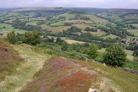
Click image to visit gallery of 3 images.
This North York Moors walk has that great combination of fantastic views, relatively easy walking and fascinating industrial history. Oh yes, and it starts near to the Lion Inn at Blakey on the C2C route. Park at Little Blakey (grid ref. SE684990) where the dismantled railway from Battersby Junction/incline crosses the Blakey Road. There are information boards here about the railway and the mine working heritage.
After parking, take the path down to the old railway, turn right and follow the route all the way to Bank Top (grid ref. SE719951). There are great views into the Rosedale valley and over to the old mine buildings. After 3.75 miles, and just before the house at Bank Top, follow the track off towards the house then bear off left downhill across the open land towards the corner of a wall/pen and then more steeply downhill through bracken. Continue right along a wall and then turn right over a stile into the golf course. The path is signed to turn left around reception and out onto Daleside Road (grid ref. SE722954).
Take the path directly across the road into Rosedale, coming out onto Gill Lane just before the bridge over the River Seven through a passageway alongside a house. Go left into the village and keep left at the junction in front of the Abbey Stores taking the road past the old school. Take either the first or second path either side of a house and go through to the campsite. Then follow the road and footpath which is signposted to Dunn Carr bridge. At the River Seven take the middle path over board steps, not crossing the river nor going uphill on the right.
Follow the path across fields then left down a farm track and follow the River Seven again on your left until you get to another bridge. Once again do not cross the bridge but go off on a part-hidden stone path leading north-west across a field. The path crosses a couple of fields and eventually becomes a track leading out at Hill Houses on Alders Road.
Cross over and take the track up past the farm. Then keep left until you pick up the old railway again, which runs along the edge of the valley. The path is easy to follow all the way back to Blakey and gives plenty of opportunities to admire the view and read the information boards at the old mine workings.
Other walks nearby
| Walk 1921 | Spaunton Moor from Chimney Bank | easy/mod | 8.1 miles |
| Walk 2077 | Glaisdale Moor circular | moderate | 11.9 miles |
| Walk 1542 | The Rudland Ridge from Ousegill Bridge | moderate | 10.1 miles |
| Walk 3187 | Esklets and Rosedale Head from Westerdale | moderate | 11.0 miles |
| Walk 2029 | Lastingham & Rosedale from Hutton-le-Hole | moderate | 12.0 miles |
| Walk 1538 | Baysdale Circular | moderate | 9.5 miles |
| Walk 1450 | Little & Great Fryup Dales | moderate | 8.3 miles |
| Walk 3398 | Rollgate Bank & Aumery Park from Fadmoor | moderate | 11.0 miles |
| Walk 3737 | Commondale & Esk Valley | easy/mod | 8.2 miles |
| Walk 1675 | The Esk Valley & Egton High Moor | moderate | 10.5 miles |
Recommended Books & eBooks
Trail and Fell Running in the Yorkshire Dales
 Guidebook to 40 of the best trail and fell runs in the Yorkshire Dales National Park. Ranging from 5 to 24 miles, the graded runs start from bases such as Ribblehead, Dent, Sedbergh, Malham and Grassington and take in the region's diverse delights, from castles and waterfalls to iconic mountains such as Whernside, Ingleborough and Pen Y Ghent.
More information
Messaging & Social Media
Message Walking Britain and follow the latest news.

Mountain Weather
Stay safe on the mountains with detailed weather forecasts - for iOS devices or for Android devices.