Ullock Pike, Long Side and Carl Side
Lake District Walk
Nat Park - Lake District - Lake District Northern Fells
Wainwrights - Carl Side, Ullock Pike
County/Area - Cumbria
Author - Lou Johnson
Length - 5.5 miles / 8.9 km Ascent - 2450 feet / 742 metres
Time - 5 hours 10 minutes Grade - moderate
Maps 

| Ordnance Survey Explorer OL4 | Sheet Map | 1:25k | BUY |
| Anquet OS Explorer OL4 | Digital Map | 1:25k | BUY |
| Ordnance Survey Landranger 90 | Sheet Map | 1:50k | BUY |
| Anquet OS Landranger 90 | Digital Map | 1:50k | BUY |
Walk Route Description
Click image to visit gallery of 12 images.
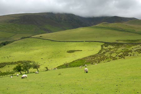
Ullock Pike, Long Side and Carl Side are three Wainwrights connected by a high ridge that is located on the south-western aspect of Skiddaw. The views south over Lake Bassenthwaite, the north-western fells, Keswick and Derwentwater are good and provide ample reason for completing this straightforward out and back excursion along the ridge.
The start of this Lake District walk is the small car park (Grid ref. NY236310) near High Side a short way along the narrow lane leading from the A591 just north of the Ravenstone Hotel to Orthwaite. After parking go through the gate adjacent to the parking area and follow the bridleway northeast towards Barkbeth. Turn right a short way along this track at a marker post and follow the obvious path uphill. Bear right through the gate on your left and continue to climb along an excellent greenway into Southerndale. Stay on this track passing the ford on your left (Grid ref NY242304) with a wonderful ahead towards Skiddaw and the ridge about to be ascended.
The path then leaves the valley and climbs to the col between The Watches and Ling How. Here you turn left and start the climb up the ridge. The path is clear and the going good and progress uphill is fairly rapid. As you climb higher there is one section over rock below the summit of Ullock Pike that needs more care before the path continues to the cairn. Looking ahead you can see the onward route, which follows the ridge. Continuing over Long Side, stay on the main path to Carl Side Tarn (Little evidence of this on the ground). Here turn sharp right on a broad path to the summit of Carl Side from where excellent views over Derwentwater maybe enjoyed.
The return route generally follows the outward route. However there are two recommended modifications. First take the direct path to Long Side from Carl Side summit. This cuts across grass and avoids the need to retrace your steps to the non-existent Tarn. Continue over Long Side and Ullock Pike as in the outward route. Reaching the col after Long How, continue ahead down the ridge to reach a wall. Turn right and follow the path down to the track in Southerndale used on the outward walk. Turn left and retrace your steps back to the start.
Other walks nearby
| Walk 2040 | Ullock Pike & Carlside | moderate | 5.5 miles |
| Walk 2244 | Whitewater Dash and Great Calva | moderate | 7.0 miles |
| Walk 2041 | Barf (via the Bishop) and Lords Seat | mod/hard | 4.0 miles |
| Walk 1177 | Great Sca Fell via Trusmadoor | moderate | 6.5 miles |
| Walk 3283 | Great Cockup and Meal Fell from Longlands | moderate | 6.0 miles |
| Walk 2581 | Lord's Seat & Barf from Whinlatter | moderate | 8.5 miles |
| Walk 1073 | Skiddaw & Glenderaterra Beck | moderate | 9.0 miles |
| Walk 1244 | Lonscale Fell & Latrigg | moderate | 7.5 miles |
| Walk 1120 | Grisedale Pike & Crag Hill fro Braithwaite | mod/hard | 8.5 miles |
| Walk 2038 | Tower Ridge on Eel Crag returning via Sail & Barrow | hard | 6.3 miles |
Recommended Books & eBooks
Walking the Lake District Fells - Buttermere
 Part of the Walking the Lake District Fells series, this guidebook covers a wide range of routes to 32 Lakeland summits that can be climbed from the Buttermere, Lorton and Newlands valleys, with highlights including Haystacks, High Stile, Grasmoor and the fells of the Coledale Round. Suggestions for longer ridge routes are also included.
More information
The Cumbria Way
 A guidebook to the 73 mile Cumbria Way, an easy long-distance walk though the heart of the Lake District National Park, from Ulverston in the south to Carlisle in the north, with good transport links to either end. The route is largely low-level but this guide offers alternative mountain days to climb some of the famous fells en route.
More information
Messaging & Social Media
Message Walking Britain and follow the latest news.

Mountain Weather
Stay safe on the mountains with detailed weather forecasts - for iOS devices or for Android devices.