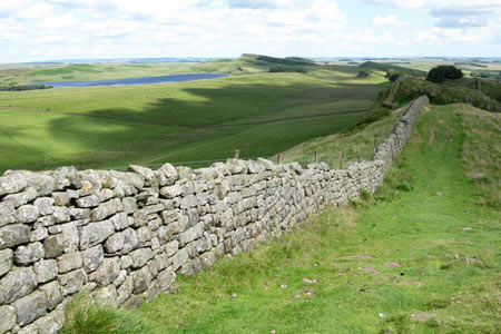
Peel Crags & Winshield Crags from Vindolanda
Northumberland Walk
Nat Park - Northumberland
County/Area - Northumberland County
Author - Lou Johnson
Length - 7.8 miles / 12.7 km Ascent - 800 feet / 242 metres
Time - 4 hours 40 minutes Grade - easy/mod
Maps 

| Ordnance Survey Explorer OL43 | Sheet Map | 1:25k | BUY |
| Anquet OS Explorer OL43 | Digital Map | 1:25k | BUY |
Walk Route Description
Click image to see photo description.
Hadrian's Wall is one the greatest legacies remaining from the Roman's occupation of the British Isles. The 84 mile long wall is followed by the Hadrian's Wall Path National Trail which was opened in 2003. This walk explores one of the more dramatic sections of the Wall and also includes Vindolanda Roman Fort. The start is the small car park south of the B6138 and east of Vindolanda at grid ref. NY773664. You can also complete the walk by using the Hadrian's Wall bus service AD122 which runs from April through to September.
After parking, exit the car park and turn right along the lane. Just after the lane turns sharp left, take the footpath on the right to pass High Shield on your left. Cross the B6138 and take the path opposite which goes half right across a field to join a track leading to the Wall. Turn left along the Wall to follow the Hadrian's Wall Path and the Pennine Way west. With Crag Lough down to your right the path climbs over Highshield Crags and continues over Peel Crags. Just before the minor road at grid ref. NY750675 there is a fine retrospective view along the wall.
Cross the minor road and continue west along the Wall passing the trig point on Winshield Crags. The path continues without any navigational problems to descend to a minor lane at Caw Gap (grid ref. NY726668). This is where this route leaves the Wall. After turning left along the lane, take the first footpath on the left. This leads you past Shield on the Wall on your right to reach the B6138. Take the minor lane opposite and walk south. After just over half a mile the road bends right (grid ref NY734654). Leave the road here and take the track on your left to pass Cranberry Brow on your right.
Reaching a lane (grid ref. NY756657), turn left. Almost immediately on your right is the access track to Layside. Take this track and pass Layside on your right. After Layside a path continues east past Kit's Shield to reach a track (grid ref. NY765659). Turn left and continue up to a lane. Go right here passing the site of Vindolanda Roman Fort on your right. Continue along this lane passing a car park on your right to reach the parking area used as the start.
Other walks nearby
| Walk 3404 | Hadrian's Wall - Cawfields to Steel Rigg | easy/mod | 3.5 miles |
| Walk 1198 | Hadrian's Wall & Steel Rigg | moderate | 8.0 miles |
| Walk 2337 | Greenlee Lough and Steel Rigg | easy/mod | 7.5 miles |
| Walk 3331 | Cragend & Crow Crags from Housesteads | easy/mod | 8.4 miles |
| Walk 3343 | Hadrian's Wall, Walltown Crags & Aesica | easy/mod | 5.0 miles |
| Walk 2803 | Hadrian's Wall and Haughton Common | hard | 20.0 miles |
| Walk 1786 | Hadrian's Wall & Simonburn circular | easy/mod | 6.8 miles |
| Walk 1987 | Allendale Town Circular | easy/mod | 6.6 miles |
| Walk 1942 | Watson's Pike & Hexhamshire Common | easy/mod | 6.0 miles |
| Walk 1477 | Bellingham to Kiln Rigg by Pennine Way Circular | moderate | 14.3 miles |
Recommended Books & eBooks
Hadrian's Wall Path
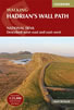 Hadrians Wall Path guidebook to walk the 84 mile National Trail. Described in both directions, the main description is west to east between Bowness-on-Solway and Wallsend, Newcastle, with extensions to Maryport and South Shields. With extensive historical information related to this World Heritage site and separate 1:25,000 OS map booklet included.
More information
The Pennine Way - the Path, the People, the Journey
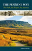 A portrait of the The Pennine Way, Britain's oldest and best known long-distance footpath, stretching 268 miles from the Peak District to the Scottish Borders. This personal, thoughtful and often humorous story of the path's remarkable history, includes the experiences of walkers and local characters on this exhilarating and complex path.
More information
Messaging & Social Media
Message Walking Britain and follow the latest news.

Mountain Weather
Stay safe on the mountains with detailed weather forecasts - for iOS devices or for Android devices.