Marsden to Edale challenge
South Pennines Walk
Nat Park - Peak District - Bleaklow Longendale
Region - South Pennines
County/Area - West Yorkshire & Derbyshire
Author - Jake Robertson
Length - 22.0 miles / 35.8 km Ascent - 5400 feet / 1636 metres
Time - 16 hours 20 minutes Grade - very hard
Maps 

| Ordnance Survey Explorer OL21 | Sheet Map | 1:25k | BUY |
| Anquet OS Explorer OL21 | Digital Map | 1:25k | BUY |
| Ordnance Survey Explorer OL1 | Sheet Map | 1:25k | BUY |
| Anquet OS Explorer OL1 | Digital Map | 1:25k | BUY |
| Ordnance Survey Landranger 104 | Sheet Map | 1:50k | BUY |
| Anquet OS Landranger 104 | Digital Map | 1:50k | BUY |
| Ordnance Survey Landranger 110 | Sheet Map | 1:50k | BUY |
| Anquet OS Landranger 110 | Digital Map | 1:50k | BUY |
Walk Route Description
Click image to visit gallery of 2 images.
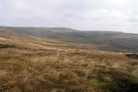
The Marsden to Edale is a classic Peak District challenge walk, 22 miles over the high bleak moorland of Black Hill, Bleaklow and Kinder Scout with only three road crossings. The choice of route is huge and it doesn't particularly matter whether you start at either Marsden or Edale as both have their own slight advantages, though you'll most likely be dictated to by the train times. For the sake of tradition I've described it north to south. Save this for good weather and allow a full day, it's a magnificent and rewarding walk.
The walk begins at Marsden train station (SE 046/118). Trains usually go from Manchester Victoria or Huddersfield every hour, with a reduced Sunday service. Walk down the hill on Station Road, turning right onto Church Lane and following this under a bridge onto Fall Lane. Head up Fall Lane; which soon becomes Binn Road leading you to Butterley Reservoir at the end of the Wessenden Valley, Marsden slipping out of sight with Edale the next settlement of any size over 20 miles away to the south. It's a slow and steady plod up the valley following the main track by the reservoirs, merging with the Pennine Way by Wessenden Lodge. Keep with the Pennine Way for some four miles all the way to the summit of Black Hill. The route is clearly signposted, crossing the Wessenden Head Road then dipping over Dean Clough before the much awaited ascent of Black Hill, made fast by flagstones through the bogs.
Reaching Black Hill's 1908ft high summit is a bit of a relief for the first major hill is now underfoot and your attention can now be drawn to Bleaklow, though it's still hidden from view. That said; you've still got to get off the hill first! Leave the safety of the Pennine Way and head for a prominent cairn to the south east and once this is reached a fairly clear cairned path leads over Tooleyshaw Moss onto a narrowing ridge before climbing onto White Low's plateau top. Bleaklow has now come into sight and looks most menacing over Longdendale. Elsewhere there is a wild sweeping view of the Black Hill massif, more than making up for the lack of views from its top. Descend steeply down on the path then veer right onto a good path below the ridge crest, skirting Brockholes Quarry and bringing you swiftly into Crowden. Go left past the Youth Hostel, cross the busy road and almost immediately over a path on the right drops onto a concessionary path by Torside Reservoir. Follow this up the end of the reservoir, crossing over by the weir and up through a small wood to the road.
Go left for a short way to the Woodhead Dam where you can join the Longdendale Trail, doubling back on yourself for a fast half mile towards the visitor centre beneath Wildboar Clough. Just before you reach this take a path on the left up into the shadowy mouth of Wildboar Clough. Following the stream up it narrows very quickly and there are a few sections of tricky waterfall scrambling which cannot be avoided, though given dry summer conditions it is fantastic stuff. Anyone with any doubts, or certainly if it's under icy or spate conditions, should take the steep slope to the right, keeping the edge of the clough on the left until the falls end and you can follow its more gentle upper reaches until near where it takes a sharp left. There's a well used path cutting over the moor to the Pennine Way which leads you quickly up to the summit of Bleaklow Head at 2077ft. Kinder looks some way off (and it is!) but mentally you're half way there, just over in terms of distance and you can look back over to Black Hill with a bit of deserved satisfaction.
Keep with the Pennine Way going south down Hern Clough to the top of Alport Low then veer off over the rough moor slipping into the head of Upper North Grain. There's a good path once you reach an old shooting cabin, fording the stream and bringing you down to the A57 Snake Pass road. Cross the road and drop down the bank, following a path down Lady Clough soon entering the woods at a stile. From here it's a long slog down through the woods by the stream and though the good paths allow a fast pace it never seems to end, frustrating for a mind now fixated on getting up Kinder Scout whose craggy edges occasionally peep through the trees. After a while the confluence with the River Ashop is reached by a wooden footbridge, you should go left up to the A57, emerging by the Snake Inn. A short stretch of enforced road walking isn't pleasant and it's a relief to reach the stile after the inn and drop down to cross a footbridge over the river to the ford over the bottom of Fair Brook.
Find a suitable place to cross then continue on the clear path heading steeply up into Gate Side Clough then tackles Seal Stones head on, the last major ascent of the day. It's a great spot for a rest for the views north back over Bleaklow to distant Black Hill are rather excellent and all the more so for having crossed them. Take the edge path eastwards to the head of Blackden Clough. Many people continue further east here, using the 7-minute crossing into Dry or Golden Cloughs and if tired, lacking time or just generally fed up of the sight of peat is it the best way. However, almost feeling guilty for missing out Kinder's summit, I prefer to ford the first main stream and follow the second one upstream and cross the moor just north of Hartshorn to pick up the edge path above Grindsbrook where the Vale of Edale comes into sight at long last. Follow the edge path right, skirting a ravine before bounding south in a last fit of enthusiasm up onto Grindslow Knoll. Finer summits than this are few and far between in Peakland and with Edale nestling in its green vale in the evening sun some 1200ft below, it's touching finale to the walk. All that's left now is the long descent down to the Nag's Head and short stroll down the road to the station.
Other walks nearby
| Walk 2613 | Boundary Walk from Marsden | moderate | 13.0 miles |
| Walk 1587 | Scammonden Reservoir | easy | 4.0 miles |
| Walk 2561 | Digley & Ramsden Reservoirs from Wessenden Head | moderate | 9.5 miles |
| Walk 2719 | Huddersfield's green fringe | easy/mod | 10.0 miles |
| Walk 2518 | Black Hill & Four Reservoirs from near Wessenden Head | moderate | 10.0 miles |
| Walk 1586 | Blackmoorfoot Reservoir | easy | 1.5 miles |
| Walk 2914 | The Pots & Pans from Uppermill | easy/mod | 4.5 miles |
| Walk 2634 | Broadstone Hill & the Cotton Famine Road | moderate | 7.0 miles |
| Walk 1583 | Digley Reservoir | easy/mod | 5.0 miles |
| Walk 1091 | Ripponden and the Calderdale Way | easy/mod | 6.5 miles |
Recommended Books & eBooks
The Pennine Way - the Path, the People, the Journey
 A portrait of the The Pennine Way, Britain's oldest and best known long-distance footpath, stretching 268 miles from the Peak District to the Scottish Borders. This personal, thoughtful and often humorous story of the path's remarkable history, includes the experiences of walkers and local characters on this exhilarating and complex path.
More information
Walking in the Peak District - White Peak East
 Guidebook describing 42 half-day and day walks in the limestone landscapes of Derbyshire's White Peak, part of the Peak District National Park. One of two volumes, this book covers the east of the region, with potential bases including Bakewell, Eyam, Castleton, Birchover, Matlock and Wirksworth.
More information
Messaging & Social Media
Message Walking Britain and follow the latest news.

Mountain Weather
Stay safe on the mountains with detailed weather forecasts - for iOS devices or for Android devices.