Highlights of Cannock Chase from Marquis Drive Walk
Walk 1731 - Route Maps
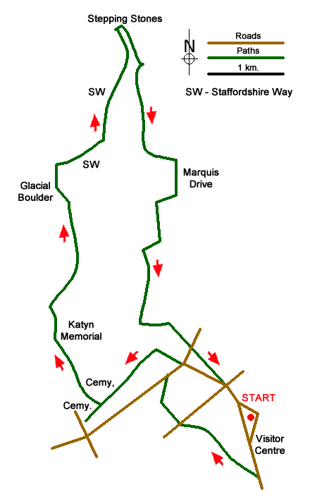
Route Map
Digital Maps - Copyright © 2011-2024. All rights reserved.
Sketch Map
Suggested Maps 

| Ordnance Survey Explorer 244 | Sheet Map | 1:25k | BUY |
| Anquet OS Explorer 244 | Digital Map | 1:25k | BUY |
It is recommended you take a map. The preferred scale is 1:25k.
Start Point Details
Ordnance Survey Grid Ref SK002153
Latitude 52.735334 Longitude -1.998477
Postcode WS12 4PW
what3words start afford.enchanted.choice
Walk description may contain detailed information on the start point for this walk.
Further Information
Cannock Chase
Cannock Chase is one of the smallest National Landscapes (formerly AONBs) and because of the proximity of large conurbations and rich mineral reserves is also one of the most threatened. 'The Chase' was once a medieval royal hunting forest and despite its proximity to areas of high density population it remains surprisingly remote. Cannock Chase Walking Guide
Staffordshire
The County of Staffordshire is located within the Midlands. The northern part of the county includes part of the Peak District National Park featuring both Gritstone moorland of the Dark Peak and limestone dales of the White Peak. To the south the heathlands of Cannock Chase form part of a National Landscape (formerly AONB). Elsewhere the county is predominantly rural with pleasant countryside and easy walking.
Walk grading - Learn how each walk is assessed and select a walk to suit your ability and experience by going to Walk Grading Details.
Messaging & Social Media
Message Walking Britain and follow the latest news.

Mountain Weather
Stay safe on the mountains with detailed weather forecasts - for iOS devices or for Android devices.