Hampton Court Parks and Gardens
Surrey Walk
County/Area - Surrey
Author - Lou Johnson
Length - 6.5 miles / 10.6 km Ascent - 230 feet / 70 metres
Time - 3 hours 30 minutes Grade - easy/mod
Maps 

| Ordnance Survey Explorer 161 | Sheet Map | 1:25k | BUY |
| Anquet OS Explorer 161 | Digital Map | 1:25k | BUY |
Walk Route Description
Click image to see photo description.
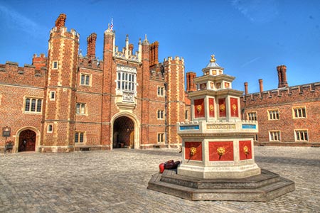
Hampton Court was one King Henry VIII's favourite palaces and is surrounded by beautiful and varied parkland on the north side of the River Thames. This walk starts from Hampton Court railway station on the south side of the Thames (grid ref. TQ153683) from where there are regular services to London Waterloo. The route then follows a section of Thames Path national trail to Kingston where the London Loop footpath is used to explore the ponds of Bushy Park and the Deer Park before passing the entrance to the Palace and across the River Thames back to the station.
From the station forecourt walk north across the River Thames following the signs for Hampton Court Palace. Once across the river, turn right and follow the Thames Path for about three miles to reach the bridge across the river at Hampton Wick. Here, follow the path up to the road over the Thames. Turn left and then left again into Hampton Court Road. Turn right in Church Grove (opposite the Kings Head Pub). After just over 100 metres, opposite St John's Church, turn left through a metal gate to walk along a tree lined avenue.
After reaching a second gate and passing the cricket ground, turn half right on a clear path (London Loop) across Bushy Park towards trees. Reaching a pond, bear left and walk along the shores of a string of ponds (which are on your right) towards a car park. Turn right over a footbridge at the end of the triangular pond (grid ref. TQ160694) which is still on your right. Cross the second bridge and turn left with water on your left. Reaching the end of the water, turn left over a bridge and keep straight ahead. Follow the London Loop waymarks across the road (grid ref. TQ158696) across a grassy area keeping w wooden fence on your right.
Turn right into the Woodland Garden. Turn left through the gardens keeping the water features on your right. A short diversion can be made to the café for refreshments. Stay on the winding path past the Pheasantry to reach the end of the gardens. Go through a gate and walk straight ahead to another gate. Enter another area of woodland bearing right to follow the London Loop waymarks to a pond with a lodge house beyond. Turn left through gardens, heading right at the second pond. Go over a bridge near a sluice house. Turn left beside a stream to exit through a gate. Here, turn left along an avenue towards the Diana Fountain.
Just before reaching the Diana Fountain, turn right and follow the road through gates. Cross over the A308 and continue through ornate gates topped with lions into Hampton Court's wilderness. Bear right past the maze, and then left passing a group of buildings. Bear right through green gates and then go left alongside the edge of the rose garden. This path leads through a brick arch near the front of Hampton Court Palace. (If you have time a visit to the Palace is a memorable and interesting way to spend a few hours.) Turn right and pass through the main gates and then go left across the River Thames and back to the start.
Other walks nearby
| Walk 3448 | Richmond Park and Petersham Circular | easy/mod | 8.9 miles |
| Walk 2173 | Hatton Cross to Uxbridge (London Loop) | moderate | 10.3 miles |
| Walk 3054 | Barnes to Richmond along the Thames Path | easy | 6.0 miles |
| Walk 1814 | Staines to Windsor along the River Thames | easy/mod | 9.0 miles |
| Walk 1326 | The Thames Path Putney to Barnes | easy | 4.0 miles |
| Walk 1447 | Tadworth Circular | easy/mod | 8.5 miles |
| Walk 1714 | Virginia Water & the Wentworth Estate | easy/mod | 9.0 miles |
| Walk 3069 | Queensway to Buckingham Palace | easy | 3.5 miles |
| Walk 3446 | Dog Rose Ramble (London Borough of Ealing) | easy/mod | 8.1 miles |
| Walk 1618 | The Box Hill Hike | mod/hard | 8.0 miles |
Recommended Books & eBooks
The Thames Path Map Booklet
 Map of the 180 mile (288km) Thames Path National Trail, from London's Thames Barrier to the river's source near Cirencester in Gloucestershire. This booklet is included with the Cicerone guidebook to the trail, and shows the full route on OS 1:25,000 maps. The easy riverside route takes around two weeks to walk.
More information
Messaging & Social Media
Message Walking Britain and follow the latest news.

Mountain Weather
Stay safe on the mountains with detailed weather forecasts - for iOS devices or for Android devices.