Bwlch y Rhiwgyr & Pont Scethin
Snowdonia/Eryri Walk
Nat Park - Snowdonia - Rhinogs
County/Area - Gwynedd
Author - Lou Johnson
Length - 9.8 miles / 15.9 km Ascent - 2000 feet / 606 metres
Time - 6 hours 50 minutes Grade - moderate
Maps 

| Ordnance Survey Explorer OL18 | Sheet Map | 1:25k | BUY |
| Anquet OS Explorer OL18 | Digital Map | 1:25k | BUY |
| Ordnance Survey Landranger 124 | Sheet Map | 1:50k | BUY |
| Anquet OS Landranger 124 | Digital Map | 1:50k | BUY |
Walk Route Description
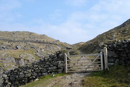
Click image to see photo description.
This Snowdonia (Eryri) walk explores an area that sees few walkers yet offers some fine views to the high mountains of northern Snowdonia. The route generally follows well sued paths and tracks. However mobile phone reception is very patchy and a paper map and the ability to read it are essential.
The start is the eastern end of Fford Gors, lane which leaves the A496 about half a mile north of Tal-y-bont. Drive to the end of the lane where limited parking is available (grid ref. SH602230). After parking, go through the gate on the right and take the lane heading south. Ignore the footpath on the left, walk past the house and cross the river using the packhorse bridge of Pont Fadog (grid ref. SH607225). Continue along the lane to a gate at the end. Turn right and in a few metres reach a junction of paths (grid ref. SH609224). Both paths are signed Ardudwy Way!
Head straight on here ignoring the path to the left. For a short way there is a wall on your right. When the wall bends to the right bear half left across fields. Continue along the path for just under one and a half miles to reach a gate by the sheepfolds marked on the OS 1:25000 map (grid ref. SH622205). Maintain your direction across the next field climbing up the field to another gate which leads to a stony path (grid ref. SH624202). Turn left and follow the twisting path as it climbs up to Bwlch y Rhiwgyr where the top is marked by a cairn.
Go through the gate at the col (grid ref. SH627200) and follow the left-hand path which heads downhill veering left towards a gate. Maintain direction down to a wall at the bottom. Here go right and the turn left through a gate. The path then follows the edge of a plantation (trees to your right and then joins an enclosed track with walls either side. Go through gate and follow the wall (on your right), cross a footbridge and through another gate. The path soon reaches a pair of gates next to each other. Continue through left-hand gate and along a track (wall to your right). After another gate bear to the left and drop down to a marker stone (grid ref. SH655202).
At the marker stone, turn left uphill keeping the wall on your right. Go through a gate onto an enclosed walled track. Leaving the enclosed track, the path follows the wall on the right and passes a ruin. The path then trends half left uphill to another wall which it follows with wall on your left. Go through two gates to reach a stile and fingerpost on the left (grid ref. SH648220). Cross the stile and follow the path which contours across the hillside to reach a wall. Bear right along the wall and go through the gate to reach the top of the pass, which is marked by a cairn (grid ref. SH637223). It is worth taking your time at this point of the walk as there is a wonderful panorama to north which includes many of the major mountains of Northern Snowdonia (Eryri).
Descend from the pass by heading straight on along the descending path. The path bends to the right and passes through a gap in a wall. Continue along the clear path heading north and still descending. The path curves sharply left and the slope eases to reach Pont Scethin (grid ref. SH634235). Cross the bridge and follow the path ahead to join a wide track with a way marker (grid ref. SH627236). Turn left and walk 600 metres to a fork. Keep left here with the main track and walk down through a large gateway. Stay on the broad track as it bends sharp right and then sharp left ignoring paths to the right and left to return to the start.
Other walks nearby
| Walk 1193 | Y Llethr & Diffwys | mod/hard | 11.5 miles |
| Walk 1194 | Bwlch Drws-Ardudwy | easy | 4.5 miles |
| Walk 1644 | Cregennen Lakes | moderate | 11.0 miles |
| Walk 1647 | Mawddach Bridge and Arthog | easy | 5.4 miles |
| Walk 3229 | Mawddach circular | moderate | 9.0 miles |
| Walk 2450 | Llynnau Cregennen & Mawddach Estuary | moderate | 8.4 miles |
| Walk 1191 | Rhinog Fawr & Gloyw Lyn from Cwm Bychan | mod/hard | 5.0 miles |
| Walk 1851 | Cregennen Lakes & Pared y Cefn-hir | easy/mod | 2.5 miles |
| Walk 2544 | Rhinog Fach circular | moderate | 8.0 miles |
| Walk 1036 | Rhinog Fach & Y Llethr | moderate | 9.0 miles |
Recommended Books & eBooks
The Wales Coast Path
 A single guidebook to walking the whole Wales Coast Path - 1400km (870 miles) the length of Wales from Chester to Chepstow, including Anglesey, described in 57 stages. The route passes through the Snowdonia and Pembrokeshire National Parks and many AONBs and can be linked with the Offa's Dyke Path for a complete circuit of Wales.
More information
Snowdonia: 30 Low-level and easy walks - South
 Guidebook describing 30 walks in Snowdonia, Wales. Routes are mostly low level and on clear paths and showcase the region's beautiful scenery and rich history and culture. Part of a 2-volume set, this southern volume includes Trawsfynydd, Bala, Dolgellau, Machynlleth, the Harlech Coast and the valleys of the Mawddach and Dyfi.
More information
Messaging & Social Media
Message Walking Britain and follow the latest news.

Mountain Weather
Stay safe on the mountains with detailed weather forecasts - for iOS devices or for Android devices.