St Catherine's Hill & Coastal Path
Isle of Wight AONB Walk
Region - Isle of Wight AONB
County/Area - Isle of Wight
Author - Lou Johnson
Length - 6.7 miles / 10.9 km Ascent - 1100 feet / 333 metres
Time - 4 hours 30 minutes Grade - moderate
Maps 

| Ordnance Survey Explorer OL29 | Sheet Map | 1:25k | BUY |
| Anquet OS Explorer OL29 | Digital Map | 1:25k | BUY |
Walk Route Description
Click image to see photo description.
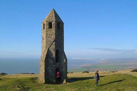
An interesting Isle of Wight walk on the south coast of the island. The route includes the fine chalk downs of St Catherine's Hill (239 metres above sea level) with its fine Oratory built in the 14th century and a lengthy section of the Coastal Path from Niton to Whale Chine. In fine weather the walk offers some wonderful views of the coast and downs.
The start is the car park at Whale Chine on the south side of the A3055 (grid ref. NZ469784). Exit the car park and turn right along the A3055. There is a grass verge, so you can avoid walking on the road. Go past the side road to Atherfield Green on the left. Just over 100 metres past this junction take the signed footpath on the left just before Walpan Farm (grid ref, NZ474781). The path goes between the house on your right and the barns on your left to enter a large field. Walk half left across this field to cross a stream (grid ref. NZ477783). Turn right before reaching a small bridge and follow the path with the hedge to your left. Continue straight ahead at a junction of paths and continue to a pump station. From here go half left across the field to reach a stile and a road (grid ref. NZ483785).
Cross the road and take the signed footpath opposite initially up a gravel track. Entering a field, keep the boundary to your immediate right and continue to a stile. Cross the stile and continue into the next field again with the field boundary on your right to another stile. Cross the stile and continue into the next field with the field boundary now on your left. Continue uphill to reach the bottom of the steep escarpment. Bear right onto a clear track that climbs the face of the escarpment. Once at the top continue in a south-easterly direction towards a fence. Bear right along the fence and continue south to reach St. Catherine's Oratory near the summit if St Catherine's Hill (grid ref. NZ493772).
Cross the fence to the trig point and bear sharp right past the radio mast. Keep alongside the hedge and join the track heading south downhill. After 700 metres of descent turn right onto a bridleway (grid ref. NZ492765) which is about 100 metres before reaching the main road. Stay on this bridleway to reach the main road after just over a kilometre of easy walking (grid ref. NZ502766).
Cross the road and take the footpath opposite. After an initial steep climb the path enters a field. The path continues following the field boundary which should be on your left. Reaching the far side of the field (grid ref. NZ503761) turn right onto the Coastal Path and follow this to reach Gore Cliff. Continue along the Coastal Path to reach a car park by the main road. Here, go left through a gate with a Coastal Path finger post and follow the path to reach the main road. Go left along the main A3055 road to reach a roundabout (grid ref. NZ488768). Stay on the A3055 (ignoring the side road going off to the left to Blackgang).
Using the grass verge, walk along the main road. You will pass a sign "Chale" marking the start of the village. The view along the coast to the west opens up and a short way further on you reach a footpath on your left (grid ref. NZ486771). Continue along the Coastal Path as it makes a loop from the A3055. Reaching the main road after 500 metres, turn left along the A3055. Go past Chale Parish Church on your right and continue past Chale Bay Farm (or Cliff Farm on some OS maps). Just after the farm, turn left onto the continuation of the Coastal Path (grid ref. NZ481776). Continue along Walpen Chine. The Coastal Path swings inland at a footpath sign to reach the A3055. Turn left along the road and the car park used at the start of the walk is a short distance ahead on the left.
Other walks nearby
| Walk 2435 | Compton Down circular | moderate | 12.5 miles |
| Walk 2350 | Appuldurcombe Circular | easy/mod | 5.5 miles |
| Walk 2916 | Gatcombe and Shorwell from Carisbrooke, IOW | moderate | 10.0 miles |
| Walk 3142 | Bowcombe Down | easy | 4.8 miles |
| Walk 1601 | Bowcombe Down & Upper Watchingwell | easy/mod | 8.0 miles |
| Walk 3745 | Ventnor Downs Circular | moderate | 7.7 miles |
| Walk 2112 | Shanklin to Sandown | easy | 3.0 miles |
| Walk 2414 | Compton Down and Five Barrows from Compton Chine | easy/mod | 5.0 miles |
| Walk 2311 | The Needles & Tennyson's Monument from Freshwater Bay | easy/mod | 6.0 miles |
| Walk 2223 | The Needles & Tennyson's Monument from Nodewell Farm | easy | 4.0 miles |
Recommended Books & eBooks
No suggestions for this area.Messaging & Social Media
Message Walking Britain and follow the latest news.

Mountain Weather
Stay safe on the mountains with detailed weather forecasts - for iOS devices or for Android devices.