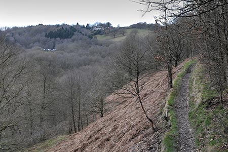
Churnet Valley from Consall Nature Park
Staffordshire Walk
County/Area - Staffordshire - North Staffordshire
Author - Lou Johnson
Length - 2.6 miles / 4.2 km Ascent - 520 feet / 158 metres
Time - 1 hours 50 minutes Grade - easy
Maps 

| Ordnance Survey Explorer 259 | Sheet Map | 1:25k | BUY |
| Anquet OS Explorer 259 | Digital Map | 1:25k | BUY |
| Ordnance Survey Landranger 128 | Sheet Map | 1:50k | BUY |
| Anquet OS Landranger 128 | Digital Map | 1:50k | BUY |
Walk Route Description
Click image to visit gallery of 3 images.
This short Staffordshire walk in the Churnet Valley is an ideal introduction to this small but scenic area. In the early part of the twentieth century the area was marketed as "Little Switzerland" with the railways bringing many thousands of visitors from the surrounding towns and cities to enjoy the landscape. Today the valley retains its scenic charm and the Churnet Valley Railway operates steam hauled heritage trains.
The start of the walk is the RSPB Consall Woods Visitor Centre (grid ref. SJ994484) which can be reached from the A520 Leek to Stone road near Wetley Rocks. From the centre of Consall village, brown signs direct you to Consall Hall Gardens. The Visitor Centre with its adjacent car park are reached by the access drive on the right just past the entrance to Consall Hall Gardens. After parking exit the car park at the opposite end to the Visitor Centre and follow the White Walk path. This leads you around a wooded steep-sided valley on a well-constructed path. The path then crosses the side of the valley offering a good view across the surrounding countryside.
After about fifteen minutes following the trail, you reach a bench (grid ref. SJ999483). Shortly after bear right onto the Purple Walk. This soon descends a long flight of steps to reach the valley floor. Keep left at the foot of the steps and continue across the River Churnet and the Churnet Valley Railway to reach the Cauldon Canal.
Turn left along the canal following the tow path. You soon pass the delightfully preserved station at Consall. Continuing along the two path, you soon reach the Black Lion Pub where food and drink is normally available. Walk under the railway, cross the river and then turn left along a track to reach a road (grid ref. SJ999486). Turn left up the road re-joining the White Walk to return to the car park.
Other walks nearby
| Walk 1284 | Churnet Valley - Kingsley to Cheddleton | easy | 5.0 miles |
| Walk 2263 | Grindon & the Manifold Way from Waterhouses | moderate | 8.0 miles |
| Walk 3562 | The Weaver Hills from Wootton | easy | 3.2 miles |
| Walk 2252 | Manifold Valley and Ecton Hill | easy/mod | 6.3 miles |
| Walk 1288 | Roaches & Hen Cloud from Tittesworth Reservoir | moderate | 8.5 miles |
| Walk 2537 | Ecton Hill & Wetton from Wetton Mill | moderate | 7.0 miles |
| Walk 1181 | Wetton Hill & the Manifold Valley | easy/mod | 6.5 miles |
| Walk 1653 | The Manifold Valley from Wetton | easy/mod | 7.8 miles |
| Walk 2681 | Wetton & Manifold Valley from Wetton | easy/mod | 3.6 miles |
| Walk 1707 | The Roaches short circular | easy/mod | 5.0 miles |
Recommended Books & eBooks
Walking in the Peak District - White Peak East
 Guidebook describing 42 half-day and day walks in the limestone landscapes of Derbyshire's White Peak, part of the Peak District National Park. One of two volumes, this book covers the east of the region, with potential bases including Bakewell, Eyam, Castleton, Birchover, Matlock and Wirksworth.
More information
Messaging & Social Media
Message Walking Britain and follow the latest news.

Mountain Weather
Stay safe on the mountains with detailed weather forecasts - for iOS devices or for Android devices.