Walk 1847 - printer friendly version
Silchester Common & Calleva Atrebatum Walk
Author - Lou Johnson
Length - 6.2 miles / 10.1 km
Ascent - 250 feet / 76 metres
Grade - easy/mod
Start - OS grid reference SU627621
Lat 51.3545240 + Long -1.1009765
Postcode RG7 2ND (approx. location only)
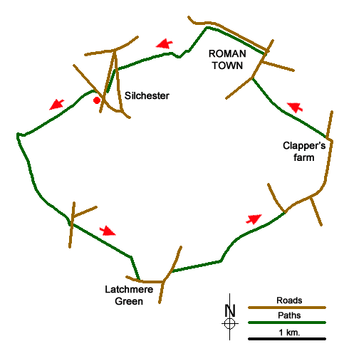
This varied Hampshire walk explores the paths of Silchester Common, Pamber Forest, the countryside near Latchmere Green, the medieval moat at Clapper's Farm and the Roman walls at Callava Atrebatum. The route mostly follows paths and bridleways and short sections of country lanes. The start is the lay--by adjacent to the Calleva Arms pub (grid ref. SU627621) which also makes an ideal stop for refreshments.
With your back towards the pub, turn left along Pamber Road. Take the first road on the left, Duke's Ride, and follow this quiet residential road for about 200 metres where a fingerpost beside a black waste bin on the right indicated the way ahead. You are now on the Brenda Parker Way and this followed across the southern part of Silchester Common for 800 metres to reach a junction of bridleways (grid ref. SU618616).
Turn left and continue along a bridleway to reach Silchester Road (grid ref. SU624606). Cross the road and take the less distinct path through woodland and then into Early Bridge Copse. With careful navigation (the relevant OS map is useful) you reach Frog Lane (grid ref. SU632200). Bear left along Frog Lane into Latchmere Green. At the first T-junction turn left along Ash Lane. After 200 metres take the signed footpath on your right (grid ref. SU634601) crossing a wooden stile to enter a grassy path with a hedge to your left and a fence to your right. After 600 metres you reach the corner of Bramley Frith Wood (grid ref. SU640602).
Bear half left here to follow the footpath along a field boundary which is to your left. This path soon joins the Brenda Parker Way again to reach a bend in a road (grid ref. SU646608). Bear to your right here and follow the road for about 350 metres to reach a T-junction (grid ref. SU649609). Turn left towards Mortimer along Clappers Farm Road and continue to reach Clapper's Farm. On the way you pass the medieval moat and fishponds which are on your left.
At Clapper's Farm the road bends to the left. Just before the road bends to the right, take the signed footpath on your left crossing a stile to enter a meadow. As before you are following the Brenda Parker Way. The path initially follows the edge of North Copse (on your right) before crossing meadows to reach Church Lane down a flight of steps (grid ref. SU643623). Continue along Church Lane passing St Mary's Church on your left. Continue ahead at the first junction to take the next lane on the left (Wall Lane). After a short way along this lane take the path through the gap in the hedge on your left and follow the path along the north side of the walls of Calleva Atrebatum, keeping wall on your left.
Continue following the wall as it bears left and continue to reach a wide track (grid ref. SU638625). Go straight across the track still following the Brenda Parker Way. After a short distance the path you need to follow bears right with another path on the left continuing south (grid ref. SU635624). Stay on this path heading roughly west to reach Bramley Road (grid ref. SU628623). Turn left and almost immediately take the path on the right through trees and follow this back to the start.
Messaging & Social Media
Message Walking Britain and follow the latest news.

Mountain Weather
Stay safe on the mountains with detailed weather forecasts - for iOS devices or for Android devices.