Walk 1888 - printer friendly version
Cissbury Ring, Chanctonbury Ring & Coombes Walk
Author - Lou Johnson
Length - 12.5 miles / 20.3 km
Ascent - 1200 feet / 364 metres
Grade - moderate
Start - OS grid reference TQ162080
Lat 50.8598460 + Long -0.3503527
Postcode BN15 0AY (approx. location only)
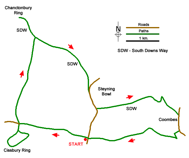
This full day West Sussex walk visits two iron-age hill forts, Cissbury Ring, and the smaller Chanctonbury Ring. The former still retains its impressive ramparts and in addition offers a wide-ranging view along the coast. Topped by a group of beech trees, Chanctonbury Ring also provides extensive views across the South Downs National Park. The lengthy route follows clear paths and tracks with good waymarking.
The start is the small parking area (grid ref. TQ162080) in the west side of Titch Hill, which can be reached from the A27 taking the road signed north past Sompting Parish Church. After parking take the clear track through a metal gate with adjacent fingerpost heading west ignoring tracks going left and right. After two kilometres you reach the small parking area (grid ref. TQ139085) at the foot of Cissbury Ring (National Trust). Turn left and follow the signed path up to the trig point. It is worth making a full circuit of the ramparts before returning downhill to the small parking area.
Reaching the foot of the hill, continue straight ahead keeping the parking area on your left. You now have a steady climb of under three kilometres, ignoring all tracks to the left and right, to reach the main ridge of the South Downs and the South Downs Way (grid ref. TQ145113). Turn left along the SDW and continue up to Chanctonbury Ring and enjoy the view. Retrace your steps along the SDW and continue ahead where you joined it from Cissbury Ring staying on the SDW.
After 1.5 kilometres of downhill walk, you join Bostal Road where you continue ahead following the SDW fingerpost. Use the path along the left-hand grass verge to enjoy the view into Steyning Bowl on the left. Ignore the Monarch's Way on the left and continue for 500 metres to a SDW fingerpost pointing left (grid ref. TQ065090). (At this point you have the option of reducing the length of the walk by 4 miles/6.5 kilometres - see final paragraph.)
To continue the route, stay on the SDW and descend steadily over Annington Hill. Nearing the foot of the descent keep a fence on your right with a pig farm beyond. Follow the track around to the left, bear right leaving the SDW down a steep slope (grid ref. TQ186094) and through a gate to enter a field. Keep to the right-hand side of the field along a bridleway to reach Coombes Road (grid ref. TQ192088).
Turn right into Coombes. After 500 metres turn right (grid ref TQ192083) soon passing a telephone box on the right. Continue up to farm and bear left through a gate following the fingerpost and then right to pass the church on your right. Enter a copse. Exiting the copse, turn right, pass through a gate, and then turn left following a bridleway along the left-hand side of a field. Continue up to pass Coombehead Wood on your right. Continue ahead with a fence on your left a group of trees which will be passed on your left. Reaching a cross track continue ahead and follow the clear track back to the start.
To reduce the length of the walk, ignore the SDW fingerpost pointing left (grid ref. TQ065090) to reach a small parking area. Fork left off the road to join a grassy bridleway that runs parallel to a fence on your left. After just under a kilometre, you reach a cross-track (grid ref. TQ168080). Turn left and follow the clear track back to the start.
Messaging & Social Media
Message Walking Britain and follow the latest news.

Mountain Weather
Stay safe on the mountains with detailed weather forecasts - for iOS devices or for Android devices.