Solsbury Hill from Northend
Somerset Walk
County/Area - Somerset
Author - Lou Johnson
Length - 3.0 miles / 4.9 km Ascent - 500 feet / 152 metres
Time - 2 hours 0 minutes Grade - easy
Maps 

| Ordnance Survey Explorer 154 | Sheet Map | 1:25k | BUY |
| Anquet OS Explorer 154 | Digital Map | 1:25k | BUY |
Walk Route Description
Click image to see photo description.
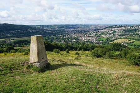
This short walk from Northern, a few miles northeast of Bath, provides a grandstand view of the City of Bath, the Avon valley, and the surrounding area. The route follows a quiet lane and paths to reach the summit of Solsbury Hill (188 m.). The hill was once the site of a hill fort, and the ramparts remain intact.
The start is the village of Northend where parking is available on Northend (street name). Park as close as you can to Seven Acres Lane (grid ref. ST779682). After parking walk up Seven Acres Lane following it around to the right. Continue ahead at the junction with Eagle Road and follow the lane as it bends left. Continue along the lane for about 800 metres ignoring the driveway on the right leading to Chilcombe House. Reaching a small stone building, take the steps to right into Chilcombe Bottom. Pass the former reservoir on your left to reach a gate by a building.
Bear right and join an enclosed track up the valley with the slopes of Solsbury Hill on your left. Pass through a gate and continue to a barn on your left. Pass through the gate and walk across the field using the electricity power line as a guide. Cross a stile, turn left and continue along the lefty-hand side of a field to a gate. The onward enclosed path leads to another gate (grid ref. ST767682). You are now entering open access lane so proceed uphill and, reaching the top, bear right and walk to the OS trig column to enjoy the excellent view.
Continue around the edge of the hilltop, pass a farm below on the right, and after 200 metres descend across the slope to reach a track by a house (grid ref. ST771680). Bear left past the hose, go through a small gate on the right. Walk half-left down the field to another gate in the far corner. Continue along the left-hand edge of two fields to a market garden. Keep to the left-hand edge to a gate on Seven Acres Lane, which is followed down to the start.
Other walks nearby
| Walk 2804 | Bath to Keynsham over Kelston Round Hill | easy/mod | 9.0 miles |
| Walk 2087 | The Cam Brook Valley from Southstoke | easy | 5.5 miles |
| Walk 3278 | Hinton & Dryham Circular | easy | 3.0 miles |
| Walk 3347 | Ford & North Wraxall from Castle Combe | easy/mod | 8.0 miles |
| Walk 1567 | Keynsham to Bath on the south side of the Avon | easy/mod | 11.1 miles |
| Walk 2699 | Lacock - a village stroll | easy | 1.0 miles |
| Walk 2212 | Bristol Curiosities Trail | easy | 1.5 miles |
| Walk 2213 | Bristol Maritime Trail | easy | 1.5 miles |
| Walk 2214 | Bristol Literary Trail | easy | 1.5 miles |
| Walk 2215 | Bristol Religious Trail | easy | 1.5 miles |
Recommended Books & eBooks
No suggestions for this area.Messaging & Social Media
Message Walking Britain and follow the latest news.

Mountain Weather
Stay safe on the mountains with detailed weather forecasts - for iOS devices or for Android devices.