Walk 1892 - printer friendly version
Minninglow & Roystone Rocks Walk
Author - Lou Johnson
Length - 5.8 miles / 9.4 km
Ascent - 600 feet / 182 metres
Grade - easy/mod
Start - OS grid reference SK195582
Lat 53.1206220 + Long -1.7100831
Postcode DE4 2PN (approx. location only)
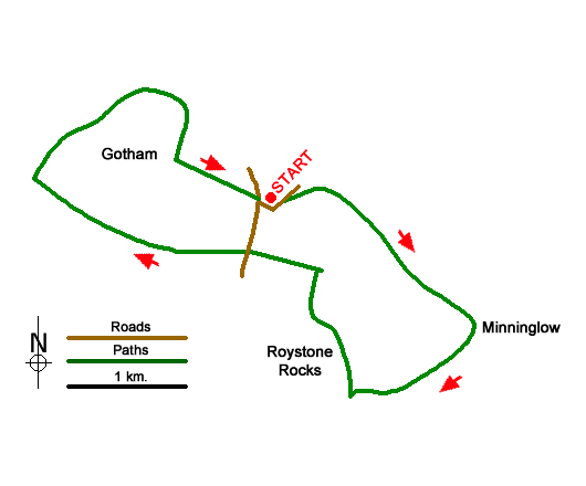
This walk explores the limestone uplands of the Peak District and uses a section the High Peak Trail which follows a disused railway to reach Minninglow. This small hill is topped by a group of trees and features well-preserved neolithic remains including a tomb and barrows. The route continues into a broad valley to pass below Roystone Rocks which can also be explored if time permits. A gradual climb across the plateau leads you back to the High Peak Trail which is followed back to the start.
The start is the Minninglow High Peak Trail car park (grid ref. SK195582) which lies less than a mile south of the B5012 at Pikehall. After parking walk to the rear of the car park and turn east along the High Peak Trail. Cross Mouldridge Lane and continue along the disused railway. The Trail swings left and then right offering a good view to Minninglow Grange down to your right. At the point where the trail bends right (grid ref. SK206575), turn left onto a concessionary path (signed to Minninglow). Pass through a gate and head uphill through two fields to a marker post. Pass through another gate to reach the edge of the group of trees.
Walk across the hill in a south-easterly direction passing the neolithic remains. Exit the trees to enter a field. Go half right down the field to reach another marker post. Continue down the next field to reach a track. Cross the track onto a footpath (signed Roystone Grange). Continue under the High Peak Trail and descend the grassy path into a broad valley. Pass between two gate posts and continue with a wall on your left. Cross a stile in the wall and maintain direction along a grassy track to a pass through a gate. Bear half left across the next field to pass a former pump house to reach a track (grid ref. SK200566).
Turn right along the track and continue through Roystone Grange Farm. Jut pass the farm you pass Roystone Rocks on your left. This is open access land and if time permits a short walk takes you up to the summit from here the view are a reward for the extra effort. Just under a kilometre from the farm you reach a junction (grid ref. SK198576). Turn left along Minninglow Lane initially climbing gently. At the next junction continue ahead onto a track (signed to Biggin). After 700 metres of easy walking the track forks (grid ref. SK185578). Bear right through the metal gate and follow the track uphill. Another kilometre of easy walking leads to a gate and a junction (grid ref. SK176583). Turn right along a clear track and gently descend to reach the High Peak Trail. Turn right and follow the trail to walk through the Gotham Curve where the railway turned sharp left. Continue ahead through Chapel Plantation and across a lane to return to the start.
Messaging & Social Media
Message Walking Britain and follow the latest news.

Mountain Weather
Stay safe on the mountains with detailed weather forecasts - for iOS devices or for Android devices.