Sandend to Cullen Coast Path
Aberdeenshire Walk
County/Area - Aberdeenshire & Moray
Author - Lou Johnson
Length - 5.0 miles / 8.1 km Ascent - 550 feet / 167 metres
Time - 3 hours 0 minutes Grade - easy/mod
Maps 

| Ordnance Survey Explorer 425 | Sheet Map | 1:25k | BUY |
| Anquet OS Explorer 425 | Digital Map | 1:25k | BUY |
Walk Route Description
Click image to see photo description.
This coastal walk starts from Sandend (Aberdeenshire) and finished in Cullen (Moray). The route follows a cliff top path offering views excellent coastal scenery with rugged cliffs, small sandy beaches, and views across the North Sea. The harbours at Sandend and Cullen offer additional interest.
The start is The Square pay and display car park in Cullen (grid ref. NJ513671). After parking catch a route 35 bus (Elgin to Aberdeen) along the A96 to the road end to Sandend. Buses depart every hour from 0808h. Journey time is less than 10 minutes. After alighting from the bus, turn left and follow the road into Sandend Village.
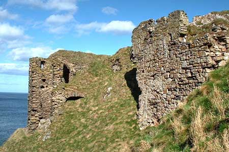
Continue along the road behind the beach. Nearing the end of the beach turn left up a concrete driveway (signed to Sunnyside Beach). Just before another house a second sign directs you to the right. Pass through a gate and join a narrow grassy path that leads onto the cliff tops. The onwards path runs between a fence on your left and the cliff top. After just under two kilometres of cliff top walking you reach the remains of Findlater Castle, which occupies a windswept position above the sea.
The path now follows a line closer to the sea and continues across the back of the isolated Sunnyside Beach with its golden sands. Pass an information board and continue around Logie Head, which offers a few climbing routes. Continue along the path nearest the sea. There is the option of climbing up to the viewpoint of Nelson's Seat before retracing your steps back to the shoreline path. Eventually the path widens into a track and later a tarmac road, which leads to the harbour. Where the road forks above the harbour, veer left and continue up to The Square.
Other walks nearby
| Walk 3081 | Bennachie and Mither Tap | moderate | 6.0 miles |
| Walk 1777 | Carn Daimh from Glenlivet | moderate | 8.5 miles |
| Walk 1771 | Ladder Hills Circular | mod/hard | 9.5 miles |
| Walk 1791 | Tarbat Ness from Porthmahomack | moderate | 9.0 miles |
| Walk 2031 | Abernethy Forest, Cairngorms | easy/mod | 10.2 miles |
| Walk 3101 | Ben Bhraggie traverse | easy/mod | 4.7 miles |
| Walk 3287 | Morven, Smean & Maiden Pap | hard | 10.2 miles |
| Walk 2607 | Lairig Ghru & Chalamain Gap from Glenmore | mod/hard | 11.0 miles |
| Walk 3579 | Meall a'Bhuachaille & Ryvoan Bothy from Glenmore | moderate | 5.5 miles |
| Walk 3218 | Eag a' Chait gap Via Rothiemurchus Lodge from Glenmore | moderate | 8.2 miles |
Recommended Books & eBooks
No suggestions for this area.Messaging & Social Media
Message Walking Britain and follow the latest news.

Mountain Weather
Stay safe on the mountains with detailed weather forecasts - for iOS devices or for Android devices.