Coombe Gibbet & Walbury Hill near Inkpen Walk
Walk 1947 - Route Maps
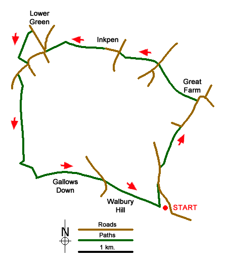
Route Map
Digital Maps - Copyright © 2011-2024. All rights reserved.
Sketch Map
Suggested Maps 

| Ordnance Survey Explorer 158 | Sheet Map | 1:25k | BUY |
| Anquet OS Explorer 158 | Digital Map | 1:25k | BUY |
It is recommended you take a map. The preferred scale is 1:25k.
Start Point Details
Ordnance Survey Grid Ref SU379615
Latitude 51.35132 Longitude -1.457161
Postcode RG17 9EH
what3words start prom.unlimited.perusing
Walk description may contain detailed information on the start point for this walk.
Further Information
North Wessex Downs
This National Landscape includes significant areas of chalk downland with their unique habitat. Man's past has left many reminders in this area too including the iconic white horses, the stone circle at Avebury and Silbury Castle. North Wessex Downs Walking Guide
Berkshire
The County of Berkshire is bisected by the Thames Valley with higher land rising to the north and south of this great river. The county has mane areas of woodland with trees that prefer acid soils. These include Bracknell Forest, Windsor Great Park, Crowthorne and Stratfield Saye Woods. The highest land lies along the Hampshire border to the south The highest point in the county is Walbury Hill at 297 metres above sea level. The open upland areas compete with Newmarket (Suffolk) for horse racing training and breeding. Away from the towns cereal crops are widespread. The major towns and centres of population include Ascot, Eton, Maidenhead, Newbury, Reading, Slough and Windsor.
Walk grading - Learn how each walk is assessed and select a walk to suit your ability and experience by going to Walk Grading Details.
Messaging & Social Media
Message Walking Britain and follow the latest news.

Mountain Weather
Stay safe on the mountains with detailed weather forecasts - for iOS devices or for Android devices.