Moray Coast Trail - Cullen to Portessie
Moray Walk
County/Area - Moray
Author - Lou Johnson
Length - 6.3 miles / 10.2 km Ascent - 400 feet / 121 metres
Time - 3 hours 30 minutes Grade - easy/mod
Maps 

| Ordnance Survey Explorer 425 | Sheet Map | 1:25k | BUY |
| Anquet OS Explorer 425 | Digital Map | 1:25k | BUY |
Walk Route Description
Click image to see photo description.
This linear walk from Cullen explores the Moray coast to Portessie using the Moray Coast Trail. The route offers pleasant, mostly easy, walking along the shore passing through Portknockie and Findochty along the way. The regular bus between Elgin and Aberdeen service (Route 35) links Portessie and Cullen to return to the start.
The start is The Square pay and display car park in Cullen (grid ref. NJ513671). After parking walk downhill to former railway viaduct. Pass under the viaduct and fork right down towards the sea. Continue downhill to the sea front and tun sharp left past the harbour on your right. Continue ahead along the road passing Cullen Beach also on your right. If tides permit, you can walk along the beach. Continue to the end of the road (or Beach) and cross the footbridge. Continue through a car park and either walk along the beach or if tides are high walk along the edge of the golf course.
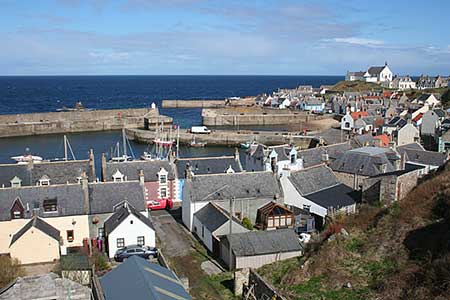
Reaching the end of Cullen Sands, join the coastal path which wends its way along the rocky foreshore to pass Bow Fiddle Rock which is home to a large seabird colony in season. Reaching the outskirts of Portknockie the coastal path turns inland to join a cul-de-sac (grid ref. NJ492686) Turn right along Addison Street which soon becomes Patrol Road. Continue to a T-junction and turn left (signed Moray Coast Trail). Continue ahead above the harbour ignoring all roads off to the left. At the end of the road re-join the coast path (grid ref. NJ486685).
Two kilometres of easy walking on a good path leads into a road on the edge of Findochty (grid ref. NJ466681). Turn right at the first cross-roads along Craigview. Continue downhill to a T-junction and turn right (signed Moray Coast Trail). At the bottom of the road continue ahead along a no through road to reach the beach. Turn left and follow the sea wall behind the beach to reach a group of wooden sheds on your right. Just past the sheds turn left along a road. Keep ahead to the first fork and keep right and shortly after at the next junction keep left. Continue along Sterlochy Street to reach Findochty harbour.
Stay on the road nearest the harbour to reach a boat park on the right. Keep ahead to the entrance to a caravan park where you continue ahead through the site to join the Moray Coast Trail. The path follows the northern edge of Starthlene Golf Club to pass the club house on your left. Continue along the path nearest the sea Portessie and a bus stop just after passing Hope Street on the left (grid ref. NJ439665). If time permits continue another 350 metres to the next bus stop.
Other walks nearby
| Walk 3081 | Bennachie and Mither Tap | moderate | 6.0 miles |
| Walk 1777 | Carn Daimh from Glenlivet | moderate | 8.5 miles |
| Walk 1771 | Ladder Hills Circular | mod/hard | 9.5 miles |
| Walk 1791 | Tarbat Ness from Porthmahomack | moderate | 9.0 miles |
| Walk 2031 | Abernethy Forest, Cairngorms | easy/mod | 10.2 miles |
| Walk 3101 | Ben Bhraggie traverse | easy/mod | 4.7 miles |
| Walk 3287 | Morven, Smean & Maiden Pap | hard | 10.2 miles |
| Walk 2607 | Lairig Ghru & Chalamain Gap from Glenmore | mod/hard | 11.0 miles |
| Walk 3579 | Meall a'Bhuachaille & Ryvoan Bothy from Glenmore | moderate | 5.5 miles |
| Walk 3218 | Eag a' Chait gap Via Rothiemurchus Lodge from Glenmore | moderate | 8.2 miles |
Recommended Books & eBooks
No suggestions for this area.Messaging & Social Media
Message Walking Britain and follow the latest news.

Mountain Weather
Stay safe on the mountains with detailed weather forecasts - for iOS devices or for Android devices.