Walk 1970 - printer friendly version
Great Knoutberry Hill & Dent Head Walk
Author - Lou Johnson
Length - 9.5 miles / 15.4 km
Ascent - 1800 feet / 545 metres
Grade - moderate
Start - OS grid reference SD780880
Lat 54.2871510 + Long -2.3394465
Postcode LA10 5RG (approx. location only)
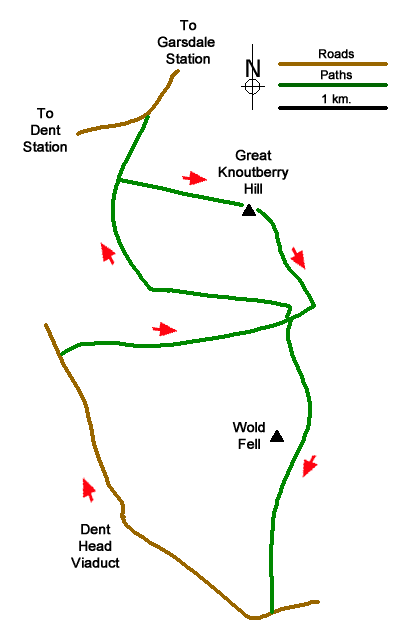
This walk explores Great Knoutberry Hill and Upper Dentdale. The route follows good paths and initially crosses wild moorland to reach the summit of Great Knoutberry Hill (672 m.) which lies at the head of Dentdale. The walk descends to Arten Gill and continues south across Wold Fell to Newby Head from where a road is followed into Dentdale. The walk passes the Settle Carlisle Railway at a number of places and uses sections of the Pennine Bridleway and Dales Way.
The start is the Coal Road which runs from Dent station to Garsdale Station. Suitable parking is available where the Pennine Bridleway leaves the road to head south across the west flank of Great Knoutberry Hill (grid ref. SD780880). Go through the gate and follow the clear track, part of the Pennine Bridleway, southwest for 700 metres to reach sheep pens on the left (grid ref. SD777874). Turn left over a stile and pass through the pens to follow a path uphill with a fence on your left. The intermittent path leads to the summit of Great Knoutberry Hill and a trig column. Take time to enjoy a wonderful panorama of hills and valleys.
From the summit, descend beside the wall down to Arten Gill. Cross the stile onto a track and turn right. After 250 metres just before a gate (grid ref. SD792861), turn left along a track (Pennine Bridleway). Cross Arten Gill and continue uphill with a wall on your right. Continue across Wold Fell to reach a gate and start the descent. Initially the path runs between walls and then with wall on your left to drop down to a lane at Newby Head Gate (grid ref. SD790835).
Turn right downhill. After a short distance, the Dales Way comes in from the left. Continue under the railway and follow the lane round to the right with the arches of Dent Head Viaduct on your right. Continue along the lane down the beautiful valley for just under two kilometres to Stone House Bridge (grid ref. SD771859). Do not cross the bridge but take the farm access drive on the right with adjacent fingerpost Pennine Bridleway). Pass the farm and continue up alongside Arten Gill on a clear track soon passing beneath the soaring arches of Arten Gill Viaduct.
Continue up beside Arten Gill for two kilometres to reach the gate encountered earlier in the walk (grid ref. SD792861). Before the gate, turn left through a gate and follow the track, initially between walls, as it curves left to contour across the hillside. From Arten Gill you have three kilometres of relaxed walking back to the start with an excellent view down Dentdale on your left.
Messaging & Social Media
Message Walking Britain and follow the latest news.

Mountain Weather
Stay safe on the mountains with detailed weather forecasts - for iOS devices or for Android devices.