Walk 1984 - printer friendly version
Nettleton Beck from Rothwell Walk
Author - Lou Johnson
Length - 8.4 miles / 13.7 km
Ascent - 700 feet / 212 metres
Grade - easy/mod
Start - OS grid reference TF151996
Lat 53.4805460 + Long -0.2670392
Postcode LN7 6BA (approx. location only)
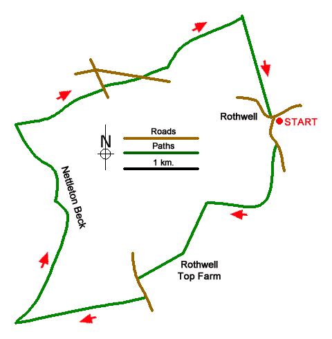
This circular Lincolnshire walk from Rothwell explores the area to the west of the village. The route includes undulating upland farmland and the deep valley of Nettleton Beck which is in contract to the many dry valleys in the area. The walk follows bridleways and a section of the Viking Way long distance footpath.
The start is the centre of Rothwell village (grid ref. TF151996). There is limited on-street parking although the Blacksmith's Arms has parking for patrons. After parking take the road south signed to Thorseway. Continue along the road for 300 metres and turn right onto a track passing through a meatal gate adjacent to a five-barred gate. After 800 metres the bridleway turns right. Continue ahead ignoring the bridleway on your left. Follow the track west to reach a T-junction (grid ref. TF142984).
Turn left and continue along the track to pass in front of Rothwell Top Farm to join the farms access drive. Continue to a road (grid ref. TF133974). Turn left along the B1225 and continue to a house on the left. Turn right onto a signed bridleway and continue across undulating farmland for 1.6 kilometres to reach the head of a valley (grid ref. TF117969) and a path junction. Turn right joining the Viking Way north into and along a deep valley containing Nettleton Beck. After 1.5 kilometres you reach a small wood (grid ref. TF123982). Follow the waymarked path to a track and turn left.
Follow the track for 150 metres and then turn right following the Viking Way for another 1.3 kilometres to pass a small reservoir on your left at Nettleton Grange Farm. Continue ahead to a clear track (grid ref. TF117995). Turn right and climb steeply out of the valley to the B1225. Veer left as you pass a derelict building and follow the grassy path east. As you near the road the route follows a clear track. Cross the road and take the bridleway opposite. Cross the road and follow the bridleway opposite. The path heads half-right across the first field to reach a junction of tracks (grid ref. TA137003). Take the track opposite. The bridleway keeps to the right-hand edge of three field to reach a cross track after just over a kilometre (grid ref. TA147009). Turn right at a four-way fingerpost and continue back to Rothwell.
Messaging & Social Media
Message Walking Britain and follow the latest news.

Mountain Weather
Stay safe on the mountains with detailed weather forecasts - for iOS devices or for Android devices.