Snowshill Circular
Cotswolds Walk
Region - Cotswolds
County/Area - Gloucestershire
Author - Lou Johnson
Length - 4.4 miles / 7.2 km Ascent - 650 feet / 197 metres
Time - 2 hours 50 minutes Grade - easy
Maps 

| Ordnance Survey Explorer OL45 | Sheet Map | 1:25k | BUY |
| Anquet OS Explorer OL45 | Digital Map | 1:25k | BUY |
Walk Route Description
Click image to see photo description.
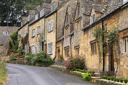
A Cotswold walk from the beautiful village of Snowshill where many of the buildings are constructed of mellow stone. The undulating route combines a section of the Winchcombe Way with part of the Cotswold Way crossing a glorious landscape. Do allow time to explore Snowshill where a small parish church dominates the centre of the village.
The start is Pipers Grove car park in Snowshill (grid ref. SP097340) located on the road to Broadway short way out of the village. It is the first car park on the left. After parking exit the car park and turn left. Continue to the main entrance to Snowshill Manor and bear half left onto the Winchcombe Way passing through a gate with adjacent fingerpost. The path is waymarked with yellow arrows and descends into a wooded valley before rising to join a lane (grid ref. SP088345).
Turn right along the lane with a plantation on your left. After 800 metres the track bears left between the plantation and Buckland Wood on your right to reach a gate (grid SP089352). Pass through the gate, left through a kissing gate still following the Winchcombe Way. Continue for 200 metres and turn left onto the Cotswold Way (grid ref. SP087354). Continue ahead on the Cotswold Way ignoring the Winchcombe Way bearing right. Continue along the Cotswold Way for 2.5 kilometres to reach Stenbarrow hillfort (grid ref. SP080333) and a path junction. Where the Cotswold Way continues ahead, turn left along a bridleway.
After 400 metres turn left and almost immediately right to re-join the Winchcombe Way (grid ref. SP084332). The path descends across fields to join a lane. Ignore tracks to the left and right and continue to the next road junction. Turn left and continue into the Snowshill village. Toi return to the car park pass to the left of the church and continue for 350 metres back to the car park.
Other walks nearby
| Walk 3063 | Stanway & Snowshill circular | moderate | 8.0 miles |
| Walk 3072 | Broadway, Stanton & Laverton | easy/mod | 7.5 miles |
| Walk 3250 | The Broadway Tower from Broadway | easy/mod | 5.0 miles |
| Walk 3327 | Temple Guiting & Cutsdean from Stanway | moderate | 10.0 miles |
| Walk 1308 | Broadway & Chipping Campden | moderate | 11.0 miles |
| Walk 3064 | Hailes, Beckbury & Sudeley from Winchcombe | moderate | 10.0 miles |
| Walk 3065 | Cleeve Common & Belas Knap from Winchcombe | moderate | 10.0 miles |
| Walk 2168 | The Slaughters | easy/mod | 8.6 miles |
| Walk 3212 | Ebrington & Foxcote circular | easy | 3.7 miles |
| Walk 2541 | Hidcote & Foxcote from Mickleton | easy/mod | 7.5 miles |
Recommended Books & eBooks
The Cotswold Way
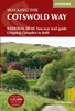 Guidebook to walking the Cotswold Way National Trail. Between Chipping Campden and Bath, the 102 mile route explores the Cotswolds AONB. Described in both directions over 13 stages, the Cotswold Way can be walked year round and is suitable for beginner trekkers. Includes separate OS 1:25,000 map booklet of the route.
More information
The Cotswold Way Map Booklet
 Map of the 102 mile (163km) Cotswold Way National Trail, between Chipping Camden and Bath. This booklet is included with the Cicerone guidebook to the trail, and shows the full route on OS 1:25,000 maps. The trail typically takes two weeks to walk, and is suitable for walkers at all levels of experience.
More information
Messaging & Social Media
Message Walking Britain and follow the latest news.

Mountain Weather
Stay safe on the mountains with detailed weather forecasts - for iOS devices or for Android devices.