Walk 2136 - printer friendly version
Wensley & Brightgate Walk
Author - Lou Johnson
Length - 6.2 miles / 10.1 km
Ascent - 1100 feet / 333 metres
Grade - easy/mod
Start - OS grid reference SK241605
Lat 53.1411090 + Long -1.6411790
Postcode DE4 2DJ (approx. location only)
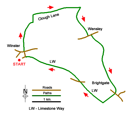
This Peak District walk explores an area of limestone uplands lying to the east of Winster. The route follows field paths to reach Clough Lane (track) which is followed through woodland to Cowley Knowl. Turning south the walk passes through the village of Wensley, passes close by Brightgate and then joins the Limestone Way to return to Winster.
The walk starts from the centre of Winster by the Market House (grid ref. SK242606). On street parking is available at a number of places in the village. Facing the post office take the lane on its right-hand side (Woodhouse Lane). At the end of the lane continue on a tarmac path down to a wooden gate and continue north down fields into a valley. Bear right at three footpath junctions and climb out of the valley across fields and briefly pass through trees to reach Clough Lane (grid ref. SK244617).
Turn right along Clough Lane and continue for 1.5 kilometres to the gateposts at Cowley Knowl (grid ref. SK259619). Bear right downhill ignoring the drive through the gateposts. Ignore tarmac Oldfield Lane on the left and continue right to a junction bearing right beside a barrier. Turn left at the fingerpost and continue through woodland. Turn right over a footbridge following the (yellow waymark (grid ref. SK258617). Continue through Cambridge Wood and then descend across a field to a road in Wensley.
Turn left and take the first path on the right (grid ref. SK262611). Descend steps into a valley. At the bottom turn left and then bear right on a rising path (not the one signed to Snitterton). The onward route crosses fields via stiles which are mostly waymarked. However the relevant OS 1:25000 map or a GPS file is useful to help with navigation. After two kilometres the path nears a lane (grid ref. SK271592). Turn right, cross a field to a gap in a hedge and a road. Go straight across to join a track (Moorlands Lane). 250 metres along the track the Limestone Way comes in from the left. Continue ahead for another 25 metres and turn right to stay on the Limestone Way, Three kilometres of excellent walking leads past Luntor Rocks to Winster.
Messaging & Social Media
Message Walking Britain and follow the latest news.

Mountain Weather
Stay safe on the mountains with detailed weather forecasts - for iOS devices or for Android devices.