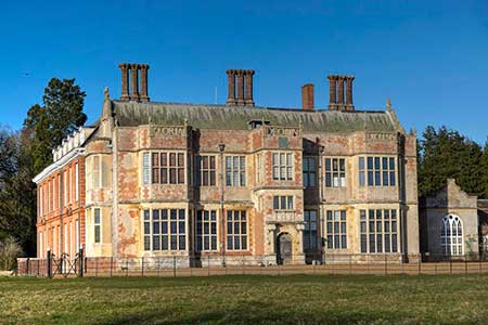
Metton & Felbrigg Hall
Norfolk Walk
County/Area - Norfolk
Author - Lou Johnson
Length - 6.2 miles / 10.1 km Ascent - 300 feet / 91 metres
Time - 3 hours 20 minutes Grade - easy/mod
Maps 

| Ordnance Survey Explorer 252 | Sheet Map | 1:25k | BUY |
| Anquet OS Explorer 252 | Digital Map | 1:25k | BUY |
Walk Route Description
Click image to see photo description.
This Norfolk walk starts from Felbrigg Hall a 17th-century English country house near the village of that name in Norfolk. Managed by the National Trust, the hall and mature parkland are located in an attractive landscape. The route uses a section of the Weaver's Way, passes through the village of Metton, and passes St Margaret's Church located in the parkland.
The start is the main pay and display car park at Felbrigg Hall (grid ref. TG195394). After parking follow the drive past the front of the Hall. Walks within in the grounds are colour coded and this walk initially uses the blue walk. Stay on the drive to reach a cattle grid (grid ref. TG191395). Turn left along the Weaver's Way and blue walk. Follow the path south to pass Felbrigg Pond (0n your left). At the southern end of the pond, turn right continuing along the Weaver's Way and leaving the blue walk which turns left. The path enters Common Plantation and exits at Cromer Road (grid ref. TG187385).
Turn right and continue to just before a road junction. Turn sharp left onto a track (signed Weaver's Way) and continue past Common Farm on your left to reach Sustead Road. Turn left and after 180 metres turn left off the Weaver's Way onto a signed footpath (fingerpost partly hidden in a small tree) across a large field. About 150 metres before reaching the far side, turn left and follow the path north to Sustead Road (grid ref. TG185376). Cross the road and turn sharp right along the field edge as indicated by the fingerpost. The path keeps to the right hand edge of the field, passes a small copse, turns left and then right and continue across a smaller field to Melton Road (grid ref. TG194373).
Turn right along the road and after280 metres go left to re-join the Weaver's Way. Follow the track (yellow waymarks) to pass Glen Farm on your left. 300 metres beyond the farm you reach a waymark (grid ref. TG198362) where the Weaver's way goes right. Turn left here and follow the path north across fields (careful navigation required) to reach the village of Metton by the church (grid ref. TG199373). Cross the road to a small stile and follow the waymarked route north via stiles to enter Metton Carrs Wood.
Continue north through the wood to a large filed. Maintain direction across the field to reach a track junction (grid ref. TG199386). Continue north for 450 metres beyond the junction and turn left. Keep to the right of St Margaret's Church and then head half right on a clear path back to the car park at Felbrigg Hall.
Other walks nearby
| Walk 2653 | Sheringham to Cley-next-the-Sea | easy/mod | 8.5 miles |
| Walk 1654 | Cley next the Sea & Salthouse | easy | 6.7 miles |
| Walk 1730 | Blakeney Point | moderate | 9.0 miles |
| Walk 2401 | Salthouse from Cley-next-the-Sea | easy | 4.0 miles |
| Walk 2297 | Honing & East Ruston Circular | easy/mod | 6.4 miles |
| Walk 3678 | Brampton & the Bure Valley from Buxton | easy/mod | 6.0 miles |
| Walk 1804 | Blakeney & Cley next the Sea | easy | 5.0 miles |
| Walk 1600 | Morston Salt Marshes from Morston Quay | easy | 2.5 miles |
| Walk 2307 | Blakeney from Morston Quay | easy | 2.0 miles |
| Walk 3732 | Morston, Blakeney & Cley next the Sea | easy | 4.0 miles |
Recommended Books & eBooks
No suggestions for this area.Messaging & Social Media
Message Walking Britain and follow the latest news.

Mountain Weather
Stay safe on the mountains with detailed weather forecasts - for iOS devices or for Android devices.