Laggan Locks Circular
Highland Walk
County/Area - Highland - Fort William Lochaber
Author - Lou Johnson
Length - 4.0 miles / 6.5 km Ascent - 300 feet / 91 metres
Time - 2 hours 20 minutes Grade - easy
Maps 

| Ordnance Survey Explorer 400 | Sheet Map | 1:25k | BUY |
| Anquet OS Explorer 400 | Digital Map | 1:25k | BUY |
Walk Route Description
Click image to see photo description.
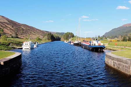
Laggan Locks lie at the southwestern end of the Caledonian Canal amidst glorious Highland scenery. This relaxing walk starts from near the shores of Loch Lochty and follows the canal past the locks to reach Loch Oich. The return route follows a lane, which is part of the Great Glen Way, back to the locks. The Caledonian Canal connects the Scottish east coast at Inverness with the west coast at Corpach near Fort William via the Great Glen and was constructed in the early nineteenth century by Scottish engineer Thomas Telford. Today most of the traffic is for leisure.
The start is the car park and picnic area west of the A82 at the head of Loch Lochty (grid ref. NN287962). After parking exit the car park and turn left towards Laggan Locks, which occupy a beautiful location amid the hills. Turn right and follow the canal northeast. The path is clear and easy to follow. After an open section by moorings the path enters woodland with occasional glimpses of the canal on your left. Leaving the trees, the outlook becomes more open before veering right to reach the A82.
Turn left along the wide grass verge and continue to the swing bridge. Cross the road and follow the tarmac path on the right-hand side of the bridge. Be prepared for a short delay if craft are using the canal. Once across the bridge stay on the footpath for 250 metres and take the road on the left signed to Balmaglaster (grid ref. NN300986). Follow the narrow road for three kilometres. Reaching the shores of Loch Lochty, turn sharp left over a cattle grid (signed the Great Glen Way) and continue past some lodges on the left to reach Laggan Locks. Cross the canal using the footway on top of either lock and return to the car park.
Other walks nearby
| Walk 3275 | Ben Tee & Kilfinnan Falls from Laggan | mod/hard | 7.5 miles |
| Walk 3289 | Loch Lundie from Invergarry | easy/mod | 6.5 miles |
| Walk 2824 | Arkaig Hills Circular | moderate | 8.8 miles |
| Walk 2918 | Aonach Mor and Aonach Beag - two of the "Lochaber giants" | mod/hard | 9.0 miles |
| Walk 3255 | Coire Ardair | moderate | 7.5 miles |
| Walk 3066 | Carn Mor Dearg (via Allt a' Mhuilinn trail) | mod/hard | 8.7 miles |
| Walk 2513 | Five day Knoydart exploration | very hard | 91.4 miles |
| Walk 2105 | Ben Nevis via Carn Mor Dearg arete | hard | 10.5 miles |
| Walk 3270 | Ben Nevis | mod/hard | 9.7 miles |
| Walk 1781 | Loch Affric Circular | moderate | 11.0 miles |
Recommended Books & eBooks
Skye's Cuillin Ridge Traverse
 This 2-volume set provides all the information required to complete the main ridge traverse on Skye's Black Cuillin. Strategy, gear, training, navigation and logistics are covered, and 10 classic scrambles are described. A lightweight second guidebook gives the scrambler detailed maps, topos and route description for the ridge traverse itself.
More information
Walking the Munros Vol 2 - Northern Highlands and the Cairngorms
 Guidebook to walking the northern Munros, covering the northern Highlands, the Cairngorms and the Isle of Skye. 70 routes are described, including those up Ben Macdui, Braeriach and Cairn Gorm. Routes range from 7 to 46km, requiring a fair level of fitness. The second of two guidebooks to walking Scotland's Munros: peaks higher than 3000ft.
More information
Messaging & Social Media
Message Walking Britain and follow the latest news.

Mountain Weather
Stay safe on the mountains with detailed weather forecasts - for iOS devices or for Android devices.