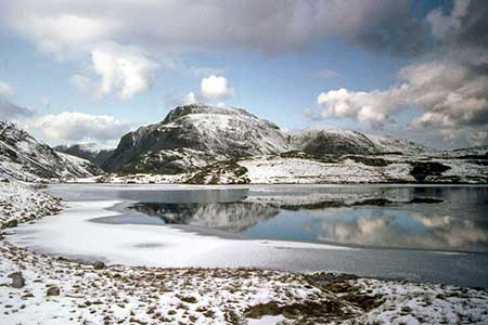
Styhead Tarn & Sprinkling Tarn from Seathwaite
Lake District Walk
Nat Park - Lake District - Lake District Western Fells
County/Area - Cumbria
Author - Lou Johnson
Length - 5.6 miles / 9.1 km Ascent - 1600 feet / 485 metres
Time - 4 hours 20 minutes Grade - moderate
Maps 

| Ordnance Survey Explorer OL4 | Sheet Map | 1:25k | BUY |
| Anquet OS Explorer OL4 | Digital Map | 1:25k | BUY |
Walk Route Description
Click image to see photo description.
Excellent Lake District walk from Seathwaite. The route visits Styhead Tarn and Sprinkling Tarn with glorious views to Great Gable, Great End and Esk Pike amongst other fells. The outward route climbs steeply from Stockley Bridge to follow Styhead Gill up to Styhead. The walk continues climbing to reach the head of Ruddy Gill which is followed downstream to Grains Gill and the start. A slightly longer route that includes Seathwaite Fell which lies north of Sprinkling Tarn can be found at Walk 1236 .
The start is Seathwaite car park (grid ref. NY235121). After parking, follow the track through the hamlet soon passing toilets on the left and a phone box. Co9ntinue ahead, pass through a gate and follow the main valley path. After just over a kilometre of valley walking you reach Stockley Bridge (grid ref. NY235109). Cross the bridge, pass through a gate and start the climb up a reinforced path. As you gain height you pass a small plantation on your left and soon after you enter the hanging valley with Styhead Gill on your right. Cross the footbridge (grid ref. NY223102) and bear right and continue up the path past Styhead Tarn and onto the stretcher box at Styhead (grid ref. NY219095).
Turn left and follow the clear path (reinforced in places) with the crags of Great End above on your right. Ignore the path on the right (Corridor Route) and continue climbing through glorious mountain scenery. A final uphill section leads to Sprinkling Tarn on your left. There is an excellent view behind you to Great Gable. Continue ahead to reach the head of Ruddy Gill which flows down a deep cleft. Turn left and follow the descending path beside Ruddy Gill. Shortly after crossing a footbridge (grid ref. NY234099), Ruddy Gill runs into Grains Gill which is followed back to Stockley Bridge. Cross the bridge and follow the clear valley path back to Seathwaite.
Other walks nearby
| Walk 1065 | Haystacks | moderate | 5.5 miles |
| Walk 1112 | Great Gable | hard | 7.3 miles |
| Walk 1245 | Castle Crag & Grange | easy/mod | 6.0 miles |
| Walk 1175 | Combe Gill Circuit | moderate | 5.5 miles |
| Walk 3328 | Eagle Crag & Seargeant's Crag from Stonethwaite | moderate | 7.0 miles |
| Walk 3133 | Ullscarf and Watendlath from Stonethwaite | mod/hard | 10.0 miles |
| Walk 1693 | Grange & Watendlath from Rosthwaite | easy/mod | 7.6 miles |
| Walk 1444 | Great Gable (Borrowdale route) | hard | 12.0 miles |
| Walk 1153 | The High Stile Ridge | hard | 10.0 miles |
| Walk 1289 | Fleetwith Pike & Haystacks | moderate | 5.5 miles |
Recommended Books & eBooks
The Cumbria Way
 A guidebook to the 73 mile Cumbria Way, an easy long-distance walk though the heart of the Lake District National Park, from Ulverston in the south to Carlisle in the north, with good transport links to either end. The route is largely low-level but this guide offers alternative mountain days to climb some of the famous fells en route.
More information
Lake District: High Level and Fell Walks
 This guidebook describes 30 graded fell walks on the ridges and high peaks of the English Lake District, the UK's most popular national park. Reaching some of England's finest and highest mountain scenery, this guide leads readers to classic horseshoes and traditional ascents as well as lesser-known routes to quieter summits.
More information
Messaging & Social Media
Message Walking Britain and follow the latest news.

Mountain Weather
Stay safe on the mountains with detailed weather forecasts - for iOS devices or for Android devices.