Walk 2195 - printer friendly version
Alston & Garrigill Walk
Author - Lou Johnson
Length - 8.7 miles / 14.1 km
Ascent - 850 feet / 258 metres
Grade - easy/mod
Start - OS grid reference NY718465
Lat 54.8125590 + Long -2.4403116
Postcode CA9 3JQ (approx. location only)
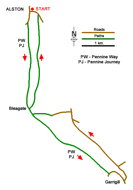
A lovely walk from the market town of Alston that explores the River South Tyne valley south to the village of Garrigill. The outward route follows the Pennine Way and Pennine Journey long distance trails which are signed. From Garrigill the walk follows the east side of the river with one section along a road before using paths and tracks to return to Alston.
The tart is the Tourist Information Centre in Alston (grid ref. NY718465). There is on street parking nearby. To start the walk, continue downhill to a T-junction and turn left to Penrith (A686). After 300 metres turn left (signed Youth Hostel) and bear right at the next junction (again signed Youth Hostel) to join the Pennine Way which is followed for 2.5 kilometres south to Bleagate Farm (grid ref. NY717437). Reaching the farm, the Pennine Way turns right to the River South Tyne.
Turn left and continue along the Pennine Way and after just over a kilometre cross the footbridge to the other side of the river, which is followed to a lane on the outskirts of Garrigill. Turn left along the road and continue to the village green in Garrigill (grid ref. NY745416). Keep to the left side of the green and continue to a road junction. Turn left (signed to Alston) past the George and Dragon Inn. Cross the river and follow the road round to the left. Stay on the road for 2.5 kilometres to a junction with the B6277, enjoying some fine views across the valley on your left.
Keep ahead at the junction and continue towards Alston. Take the first lane on the left (No through road) and descend into the valley with further fine views of the area. Nearing the bottom of the hill the lane veers right and becomes less well maintained. Turn left at the fingerpost (grid ref. NY722435). After a few metres leave the track and follow the path alongside a wall (on your right). Enter the next field you meet the Pennine Way. Do not follow the PW but turn right through the wall and keep the wall on your right to reach the access drive to Bleagate Farm. Turn right along the access track and continue north to a three-way junction (grid ref. NY720444).
Bear left and take the first footpath on the right. The path continues across two fields to enter woodland. Cross the footbridge over Nattrass Gill and exit the trees. The path crosses fields to a lane and house at Annat Walls. Follow the lane for a kilometre to reach some bungalows on the outskirts of Alston (grid ref. NY720460). Turn left down a no through road. Just past the last bungalow on the right, turn right onto a path that leads you to the A689. Turn left and continue back into Alston.

Mountain Weather
Stay safe on the mountains with detailed weather forecasts - for iOS devices or for Android devices.

