Clowbridge Reservoir & Singing Ringing Tree
South Pennines Walk
Region - South Pennines
County/Area - Lancashire
Author - Lou Johnson
Length - 4.0 miles / 6.5 km Ascent - 500 feet / 152 metres
Time - 2 hours 30 minutes Grade - easy/mod
Maps 

| Ordnance Survey Explorer OL21 | Sheet Map | 1:25k | BUY |
| Anquet OS Explorer OL21 | Digital Map | 1:25k | BUY |
Walk Route Description
Click image to see photo description.
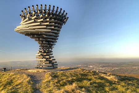
A short South Pennines walk exploring Clowbridge Reservoir and the Singing Ringing Tree. The route follows good paths in an area developed for walkers and includes the reservoir and a memorial garden. The Singing Ringing Tree is a unique wind powered sound sculpture resembling a tree, which overlooks Burnley from its position high above the town on Crown Point.
The start is the free Crown Point car park (grid ref SD848288). After parking, face the road and turn left. Just before the cattle grid, bear right off the road and follow the path to cross a stile. Stay on the clear path for 500 metres to where the path forks. Keep right here and continue down to a track and turn right downhill (grid ref. SD846280). Stay on the track to reach a junction of paths and tracks at Compston's Cross (on your left).
Follow the main track which leads down to Clowbridge Reservoir. Walk along the shore and turn right before a small building and electricity pylon. Stay on a clear track soon passing the Dunnockshaw Memorial Garden on your left. The excellent path soon bends left and passes through trees and beside woodland your left. Pass through a gate (grid ref. SD837287) and continue ahead with trees on your right. Just past the end of the trees fork right, pass through the derelict wall, and then follow the wall which should be on your right.
After 300 metres you reach a wider track. Turn left. Note the ruins of Crown Point are short walk to your right. Follow the path, initially with trees on your left up to Crown Point Road (grid ref. SD843292). Cross the road to the squeeze stile opposite and follow the path which runs roughly parallel to the road. Continue to a decorated cairn. Just past the cairn, the path forks. Keep left to join a wider path. Turn left and continue to the Singing Ringing Tree. Besides the interesting sculpture there is an excellent view over Pennine moors and Burnley. Retrace you steps along the path and return to the car park.
Other walks nearby
| Walk 2606 | Hoof Stones Height, Noah Dale and Colden Water | moderate | 11.5 miles |
| Walk 2183 | Irwell Sculpture Trail | easy | 4.5 miles |
| Walk 1458 | The Rossendale Way from Greave | easy/mod | 7.0 miles |
| Walk 1411 | Walsden & Warland Reservoir | easy/mod | 6.5 miles |
| Walk 3719 | Ramsden Wood & Hades Hill from Walsden | easy/mod | 6.1 miles |
| Walk 3111 | Barley Circular | easy/mod | 7.5 miles |
| Walk 2564 | Calf Hey, Ogden & Holden Wood Reservoirs | moderate | 7.5 miles |
| Walk 2624 | Tor Hill & High Moss, Nr Haslingden | moderate | 7.0 miles |
| Walk 1747 | Oswaldtwistle Moor | easy/mod | 6.0 miles |
| Walk 3015 | Stoodley Pike & Withens Clough Reservoir from Lobb Mill | moderate | 9.0 miles |
Recommended Books & eBooks
Walking on the West Pennine Moors
 This guidebook describes 30 walks on the West Pennine Moors, around Blackburn, Darwen, Chorley and Bolton, home to some of the most inspiring and exhilarating walking country. The walks range from short, easy rambles to more challenging hikes covering a variety of terrain, all of it easily accessible for day walking.
More information
Messaging & Social Media
Message Walking Britain and follow the latest news.

Mountain Weather
Stay safe on the mountains with detailed weather forecasts - for iOS devices or for Android devices.