Somerleyton & Herringfleet Hills
The Broads Walk
Nat Park - The Broads
County/Area - Suffolk
Author - Lou Johnson
Length - 3.5 miles / 5.7 km Ascent - 100 feet / 30 metres
Time - 1 hours 50 minutes Grade - easy
Maps 

| Ordnance Survey Explorer OL40 | Sheet Map | 1:25k | BUY |
| Anquet OS Explorer OL40 | Digital Map | 1:25k | BUY |
| Ordnance Survey Landranger 134 | Sheet Map | 1:50k | BUY |
| Anquet OS Landranger 134 | Digital Map | 1:50k | BUY |
Walk Route Description
Click image to see photo description.
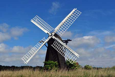
This short walk in The Norfolk Broads provides a pleasant couple of hours alongside the River Waveney. The highlight of the route is for many the lovely Herringfleet Drainage Mill. The route also includes the Herringbone Hills. However, do not expect these to be too challenging as the highest point is only 80 feet above sea level!
The start of the walk is the village of Somerleyton (grid ref. TM478971). The village lies a few miles south-west of Great Yarmouth just off the B1074 south of St Olaves. Parking is restricted and the Duke's Head will, I am sure, allow parking if you are a customer. After parking make your way down the lane to the Marina and the River Waveney. Turn right along the banks of the River and continue north for a kilometre to reach the Herringfleet Drainage Mill.
Turn right away from the river and follow the path into the Herringfleet Hills, which are as the name suggests some of the highest land in the vicinity. Reaching only 80 feet above sea level you are unlikely to meet any steep paths so just relax and enjoy the view. The return follows the outward route.
Other walks nearby
| Walk 2320 | Muck Fleet & River Bure from near Oby | easy/mod | 8.7 miles |
| Walk 2239 | River Bure and Tunstall Dike from Acle | easy | 6.1 miles |
| Walk 2240 | The River Bure & Upton from Acle | easy | 5.0 miles |
| Walk 2446 | Rockland St Mary Circular | easy/mod | 8.1 miles |
| Walk 3348 | River Yare & Claxton from Rockland Staithe | easy | 5.2 miles |
| Walk 2128 | Stokesby & Muck Fleet from Fleggburgh | easy | 7.1 miles |
| Walk 3603 | Blythburgh from Wenhaston | easy | 5.0 miles |
| Walk 3694 | River Thurne & Hickling Broad from Potter Heigham | easy/mod | 6.4 miles |
| Walk 1775 | Walberswick Circular | easy | 4.5 miles |
| Walk 2014 | Southwold | easy | 4.0 miles |
Recommended Books & eBooks
Suffolk Coast and Heath Walks
 Guidebook to three long-distance routes exploring the varied landscapes of the Suffolk Coast and Heaths AONB. The Suffolk Coast Path covers 55 to 60 miles from Lowestoft to Felixstowe. The Stour and Orwell Walk is 40 miles from Felixstowe to Cattawade near Manningtree, while the Sandlings Walk is 59 miles from Ipswich to Southwold.
More information
Messaging & Social Media
Message Walking Britain and follow the latest news.

Mountain Weather
Stay safe on the mountains with detailed weather forecasts - for iOS devices or for Android devices.