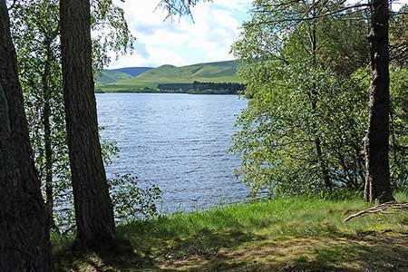
Gladhouse Reservoir
Midlothian Walk
County/Area - Midlothian
Author - Lou Johnson
Length - 4.0 miles / 6.5 km Ascent - 250 feet / 76 metres
Time - 2 hours 20 minutes Grade - easy
Maps 

| Ordnance Survey Explorer 344 | Sheet Map | 1:25k | BUY |
| Anquet OS Explorer 344 | Digital Map | 1:25k | BUY |
| Ordnance Survey Explorer 345 | Sheet Map | 1:25k | BUY |
| Anquet OS Explorer 345 | Digital Map | 1:25k | BUY |
Walk Route Description
Click image to see photo description.
Gladhouse Reservoir is located in the Moorfoot Hills to the south of Edinburgh. The walk is easy using tracks and quiet country roads. The route follows a clockwise circuit of the Reservoir and some care is needed with navigation along the tracks to the south of the Reservoir. The reservoir is home, depending on season, to a number of birds so taking a pair of binoculars might be useful.
The start is on the north-eastern shore of the reservoir where a number of convenient parking areas are available (grid ref. NT304544). After parking walk 'clockwise' with the reservoir to your left and continue along the quiet road until it ends at Mauldslie (grid ref. NT309530). Here the road splits and you should turn right. Almost immediately take the track on your left heading across fields in a south-easterly direction. Continue along this track for just over 600 metres passing a small plantation on your left to reach a junction of tracks (grid ref. NT306524).
Turn right here and follow the clear track passing Huntly Cottage on your left (grid ref NT301526). Keep straight ahead here ignoring the track coming in from the right and continue to Moorfoot (grid ref. NT297523). Here walk through the gap between the buildings and join the lane, which heads north. After just under a mile you reach a T-junction (grid ref. NT284531). Turn right along this busier road to take the first road on your right and continue to follow this crossing the dam and your parked car.
Other walks nearby
| Walk 3292 | Carnethy Hill, Black Hill & Caerketton Hill | mod/hard | 12.5 miles |
| Walk 1936 | Scald Law and Pentland Hills Ridge from near Penicuik | mod/hard | 7.4 miles |
| Walk 3291 | West Kip, East Kip & Scald Law | moderate | 9.7 miles |
| Walk 1700 | Edinburgh - Royal Mile, Arthur's Seat & Princes Street | easy | 5.5 miles |
| Walk 1803 | Edinburgh - Salisbury Crags and the Royal Mile | easy | 4.0 miles |
| Walk 2061 | Edinburgh - Calton Hill and the city centre | easy | 3.0 miles |
| Walk 3294 | Trahenna Hill from Broughton | moderate | 7.1 miles |
| Walk 3293 | Three Brethren & Brown Knowe from Yarrowford | moderate | 8.3 miles |
| Walk 1944 | Yarrow Valley Five Hills Circular | mod/hard | 11.4 miles |
| Walk 2734 | The Eildon Hills | easy/mod | 5.3 miles |
Recommended Books & eBooks
No suggestions for this area.Messaging & Social Media
Message Walking Britain and follow the latest news.

Mountain Weather
Stay safe on the mountains with detailed weather forecasts - for iOS devices or for Android devices.