Walk 2255 - printer friendly version
Urchfont Hill from Market Lavington Walk
Author - Lou Johnson
Length - 8.6 miles / 14 km
Ascent - 550 feet / 167 metres
Grade - easy/mod
Start - OS grid reference SU016542
Lat 51.2869340 + Long -1.9784413
Postcode SN10 4AT (approx. location only)
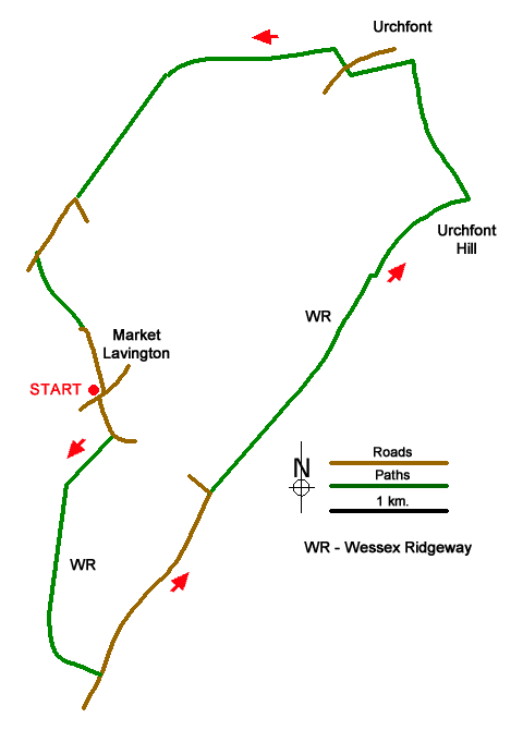
Walk from Market Lavington (Wiltshire) that explores a section of the Wessex Ridgeway to the south of the village. The route follows paths and bridleways to explore the downs before crossing countryside back to the start. One section of the walk follows the boundary of Westdown Artillery Range and you should obey all instructions.
The start is small. car park in the centre of Market Lavington (grid ref. SU016542) situated at the junction of High Street (B3098) and Northbrook. After parking, return to the High Street and turn right soon passing The Cooperative on the right. Take the first road on the left opposite the phone box (White Street). Continue along the road for 220 metres to where the road bends left. Fork right to join a track. Stay on the track ignoring tracks and paths left and right. After 1.5 kilometres the track joins a narrow lane in trees (grid ref. SU011524). Bear left and at the next junction fork left onto a signed bridleway. This leads you up the escarpment onto the ridge.
Reaching a tarmac lane, turn left. You are now following the Wessex Ridgeway and White Horse Trail. From this point onwards the artillery range is on your right. Continue along the lane for 1.6 kilometres passing a radio tower on the left to reach a junction with a small building on your right (grid ref. SU024534). Go straight across the junction and follow the broad track. Continue ahead with the next landmark a small wood on your right (grid ref. SU034546). Where the track swings right walk ahead towards a small copse on the flank of Urchfont Hill. Just before the trees fork right onto a grassy track (keeping the trees on your left), You re-join the wider track which soon runs beside a fence on the left.
Turn right at the waymarked bridleway a few metres along the fence and join a descending grassy track (grid ref. SU044557). Descending quite steeply down the escarpment continue towards Urchfont village. Reaching flatter ground, turn left onto a signed footpath just before some buildings (grid ref. SU040568). Follow the path along the edge of fields to reach a metal barn on your left. Just after the barn, turn right and continue to the B3098.
Cross the road to the byway opposite (signed bridleway). The lane soon bends left. Continue ahead to the next junction reached after a further kilometre. Bear left at the junction and after 700 metres pass Sands Farm on your right to join a tarmac lane. Keep straight on at three junctions and 400 metres beyond the third junction you reach a cottage on your left (with a post box in the wall) and s signed bridleway on your right (Parnham Lane). Turn left just past the cottage and then go through the gap in the hedge on your right and follow a path across fields back to Market Lavington. Reaching the outskirts of the village continue ahead into Northbrook. The car park used at the start is on the right after 400 metres.
Messaging & Social Media
Message Walking Britain and follow the latest news.

Mountain Weather
Stay safe on the mountains with detailed weather forecasts - for iOS devices or for Android devices.